Catalog Archive
Auction 104, Lot 119

"A Map of the British Empire in America with the French, Spanish and Hollandish Settlements adjacent thereto by Henry Popple", Popple/Covens & Mortier

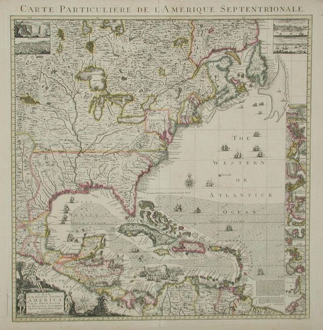
Subject: Colonial North America

Period: 1741 (circa)

Publication:

Color: Hand Color

Size:
19 x 19.2 inches
48.3 x 48.8 cm
Download High Resolution Image
(or just click on image to launch the Zoom viewer)

This is the index sheet of the Dutch version of Henry Popple's important map of the British Empire in North America published by Covens and Mortier. Popple's map is the finest and most detailed map of America of its time and covers the eastern part of North America between the Mississippi and Newfoundland and the adjoining regions of Central and South America and the Caribbean. In upper left and right hand corners are insets of Niagara Falls, Mexico City, Quebec and New York City. At right is a column of 18 plans of ports, harbors and islands including Cartagena, Charleston, Bermuda, New York, and Boston. The map is richly embellished with a title cartouche featuring Native Americans, monkeys, a crocodile and a scene of European traders. Numerous ships and sea battles are shown throughout the oceans that are hachured to depict current directions. Engraved by Johannes Condet.

References: Cumming (SE) #231; McCorkle #741.3.

Condition: A

Fine original color and impression. Lightly toned with a tiny hole in wide blank margins, well away from map.

Estimate: $3,000 - $3,500

Sold for: $3,000

Closed on 9/10/2003

Archived