Catalog Archive
Auction 103, Lot 224

"Mappa Geographica, complectens I. Indiae Occidentalis Partem Mediam Circum Isthmum Panamensem II. Ipfumqs. Isthmum. III. Ichnographiam praecipuorum locorum & portuum ad has terrais pertinentium Desumta omnia ex Historia Insulae …", Homann Heirs

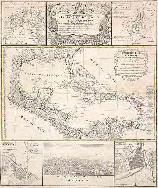
Subject: Gulf of Mexico and Caribbean

Period: 1740 (dated)

Publication:

Color: Hand Color

Size:
19.2 x 23 inches
48.8 x 58.4 cm
Download High Resolution Image
(or just click on image to launch the Zoom viewer)

Informative and very graphic folio sheet with a large map of the region, titled "Carte des Isles de l'Amerique et Deplusieurs Pays de Terre Ferme" attributed to D'Anville (1731). It covers the Gulf of Mexico, Central America and all of the Caribbean islands. It is nicely detailed with a color key to show European possessions and a beautifully engraved title cartouche. Above the main map is the large title cartouche, flanked by insets of the isthmus of Panama and a plan of St. Augustine in Florida. Below the map is a large view of Mexico City, flanked by plans of Vera Cruz and San Domingo. A very handsome sheet.

References:

Condition: B

Nice impression with original color. Small area of paper transfer across centerfold south of Cuba.

Estimate: $800 - $1,000

Sold for: $650

Closed on 6/11/2003

Archived