Catalog Archive
Auction 103, Lot 186

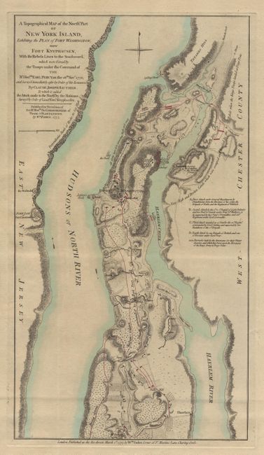
"A Topographical Map of the Northn. Part of New York Island, Exhibiting the Plan of Fort Washington, now Fort Knyphausen, with the Rebels Lines to the Southward…", Sauthier/Faden

Subject: New York

Period: 1777 (dated)

Publication:

Color: Hand Color

Size:
10.2 x 18.5 inches
25.9 x 47 cm
Download High Resolution Image
(or just click on image to launch the Zoom viewer)

Revolutionary War battle plan depicting northern Manhattan Island. The title continues "which were Forced by the Troops under the Command of The Rt. Honble. Earl Percy,...Novr. 1776...To which is added the Attack made to the Northd. by the Hefsians. Survey by order of Lieutt. Genl. Knyphaufen." Nebenzahl says this is the "most accurate delineation of Upper Manhattan to have been published up to this date." It gives a detailed look at the British and Hessian troop movements in their attack on Fort Washington, the last American stronghold in the battle for Manhattan. General Nathaniel Greene lost 2,800 American men in a major defeat for the Americans. His army surrendered to German mercenary soldiers, commonly called Hessian. A very detailed map that gives important topographical information on waterways, slopes, farmlands, roads, batteries and the fort. A scarce and most desirable map.

References: Nebenzahl, #14; Stokes Manhattan, p.355-356.

Condition: A

Very nice example on thick paper with original color. Two small tears in top blank margin, closed with archival tape.

Estimate: $1,600 - $2,000

Unsold

Closed on 6/11/2003

Archived