Catalog Archive
Auction 103, Lot 149

"Dept. of the Interior. Pacific Wagon Roads. Map No. 1 of the El Paso & Fort Yuma Wagon Road", U.S. Department of Interior
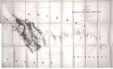
Subject: Arizona

Period: 1857-8 (dated)

Publication: Campbell's Wagon Roads…A Report Upon the Several Roads Constructed.

Color: Black & White

Size:
36.3 x 23.3 inches
92.2 x 59.2 cm
Download High Resolution Image
(or just click on image to launch the Zoom viewer)

An important map that shows a very early boundary for the proposed territory of Arizona, which was to be located in the southern portion of New Mexico Territory. Very detailed along the route of the wagon road and locates springs, mail stations, forts, tanks, Indian villages, missions, and much topographical information. The route from El Paso travels through Las Cruces, Cooke's Spring, El Piloneillo (near the current AZ/NM border), Parke's Railroad Pass and north to the junction of the Salt River, then northwest to Pima Villages (Phoenix).

References: Wheat (TMW) #944.

Condition: B

Lightly toned along folds, some intersection splits and marginal splits with no loss.

Estimate: $120 - $150

Sold for: $160

Closed on 6/11/2003

Archived