Current Auction
Price reduced by $45
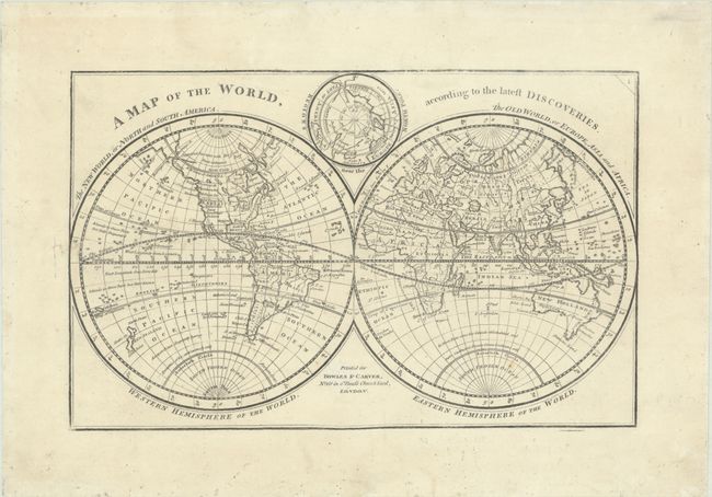
"A Map of the World, According to the Latest Discoveries", Bowles & Carver
Subject: World
Period: 1785 (circa)
Publication:
Color: Black & White
Size:
11.1 x 7 inches
28.2 x 17.8 cm
Download High Resolution Image
(or just click on image to launch the Zoom viewer)
(or just click on image to launch the Zoom viewer)
This scarce and handsome world map presents "the New World of North and South America" as well as "the Old World of Europe, Asia and Africa." In North America, the United States is confined to east of the Appalachians with Florida occupying the Gulf Coast and Mexico beyond the Mississippi River. Several place names are noted along the Pacific coastline including New Albion, Port Drake, and Juan de Fuca's Inlet. The Alaskan coastline is still evolving and above the Bering Sea is a "Supposed Sea Open with Parts Unknown." In the South Pacific, New Zealand is fully formed, while the Australian coastline is shown with Tasmania still attached to it. There are a few notes along the Antarctic Circle including "An open Ocean, frequently having Quantities of Ice, and intensely cold." Nestled between the hemispheres is an inset map of the North Pole. We found only one past sales record for this map in the last 30 years.
References:
Condition: A
Issued on paper with a Strasbourg Lily watermark. There is a small repaired hole in the left blank margin.
Estimate: $325 - $400
Price: $195
Bid Increments
Under $50$1
$50 - $100$5
$100 - $250$10
$250 - $500$25
$500 - $1000$50
$1000 - $2500$100
$2500 - $5000$250
Above $5000$500