History of the Louisiana Purchase
"[Map in Book] Carte Generale des Etats-Unis pour Servir a l'Histoire de la Louisiane [in] Histoire de la Louisiane et de la Cession de Cette Colonie par la France aux Etats-Unis de l'Amerique Septentrionale...", Barbe-Marbois, Francois
Subject: United States, Louisiana Purchase
Period: 1829 (published)
Publication:
Color: Hand Color
Size:
13.3 x 9.4 inches
33.8 x 23.9 cm
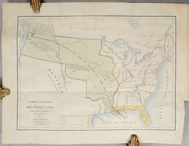
Francois Barbe-Marbois represented France in the preliminary negotiations with the United States on the Louisiana Purchase and his book provides one of the most important sources of information on the subject. He disputes the claim by the United States, in the negotiations with Great Britain, that the northern boundary of Louisiana included the area now comprised in Oregon, Washington and Idaho. The book features the important folding map Carte Generale des Etats-Unis, which shows the United States prior to the Louisiana Purchase, the region of the Louisiana Purchase, and Florida (ceded by the Spanish). The map also notes the contested region in the west as part of the Oregon Boundary dispute between the British and Americans. First edition. 8vo, 485 pp., Imprimerie de Firmin Didot. Contemporary quarter-calf and speckled paper-covered boards with gilt decorations and red leather title label on spine.
References: Howes #B-115; Sabin #3306.
Condition: A
The map is in contemporary color on a bright sheet with very light offsetting. The text is also clean and bright. The covers are rubbed, the top of the spine is chipped, and there is some worm damage to the leather on the back cover.