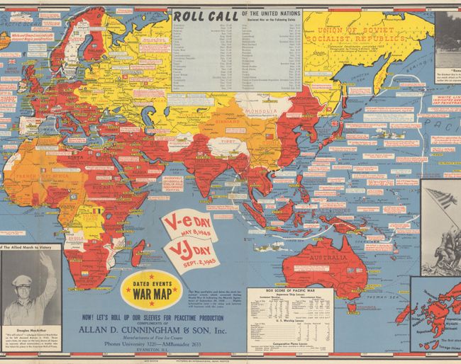
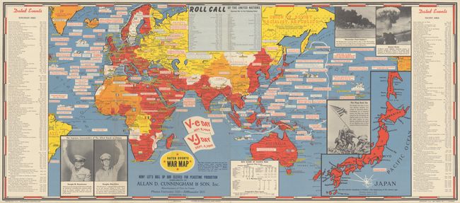
"Dated Events War Map [28th Edition]", Turner, Stanley
Subject: Eastern Hemisphere, World War II
Period: 1945 (dated)
Publication:
Color: Printed Color
Size:
38.6 x 16.9 inches
98 x 42.9 cm
This is one of the final editions in Stanley Turner's sequence of maps chronicling World War II, published in the aftermath of the atomic bombings at Hiroshima and Nagasaki. The map is densely packed with information on notable events in Europe, Asia, Africa, and Australia. An inset of Japan at right notes "the first atomic bombing in history - the beginning of the atomic age." There are black & white photographs, courtesy of International News Photos, showing generals Dwight D. Eisenhower and Douglas MacArthur, the attack on Pearl Harbor, a mushroom cloud, and the iconic image of soldiers hoisting the flag at Iwo Jima. A table at left provides a chronology of events in Europe, while a table at right does the same for the Pacific. Other tables show when each of the United Nations officially declared war and the tally of ships and planes lost in the Pacific theater. Flags near the title commemorate V-E Day and V-J Day. Produced by C.C. Petersen Advertising in Toronto, with a copyright date of 1942. Printed by Shaw-Barton in Coshocton, Ohio.
For a brief article on the Turner maps, click here.
References: Rumsey #6773.
Condition: B+
Issued folding, now flat, with light wear and a few tiny holes along the folds, and minor soiling.