Popple's Epic Map - Mexico Sheet
"[A Map of the British Empire in America (Sheet 13) - Mexico]", Popple, Henry
Subject: Mexico
Period: 1733 (circa)
Publication:
Color: Black & White
Size:
26.3 x 19.2 inches
66.8 x 48.8 cm
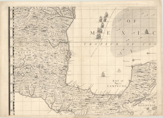
Sheet 13 of Popple's 20-sheet map of the British Empire in North America focuses on Mexico, spanning from the mouth of the Rio Grande to the Yucatan Peninsula. It renders the region in fine detail and identifies Mexico City, Leon, Panuco, Xalapa, Veracruz and the Castle and Isle of St. Juan de Lua, Oaxaca, Acapulco, Campeche, Merida, and more. In the waters, shoals, offshore islands, and trade winds are noted along with a number of ships demonstrating "the course of the Spanish Galleons from Vera Cruz to the Havana to avoid the Trade Winds."
Henry Popple based his map on firsthand information gathered over several years at the Board of Trade and Plantations. The map was the first large-scale British map to provide an overall view of the eastern half of North America. As tensions grew between the colonial powers, the map became immensely influential throughout Europe and was copied by several cartographers. This example is state 5 or later, as it includes a sheet number engraved at top right.
References: Cumming (SE) #216; Pritchard & Taliaferro #24.
Condition: B+
A fine impression on sturdy, watermarked paper with a few tiny splits along the centerfold, a couple of which have been closed on verso with archival materials. There are light spots around the centerfold, a few miniscule wormholes that are only visible when the map is held to light, and an edge tear just entering map image at bottom that has been archivally repaired.