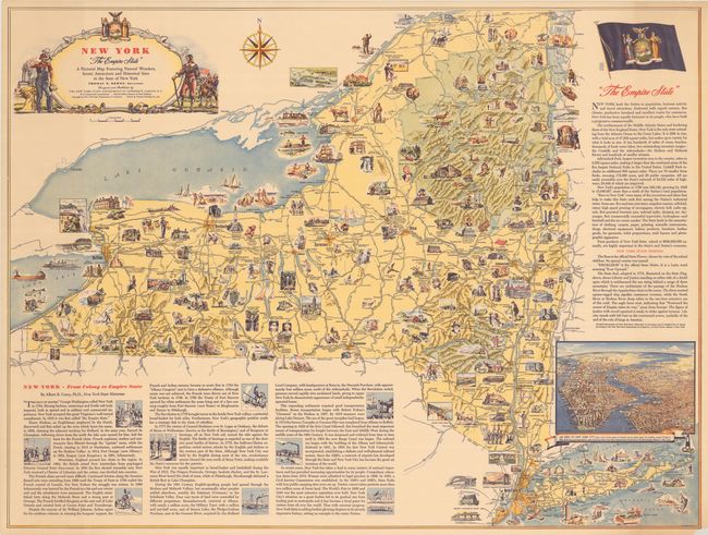
"New York "The Empire State" - A Pictorial Map Featuring Natural Wonders, Scenic Attractions and Historical Sites in the State of New York",
Subject: New York
Period: 1946 (circa)
Publication:
Color: Printed Color
Size:
38.9 x 29.3 inches
98.8 x 74.4 cm
This large, handsome pictorial map of the state was designed and published by the New York State Department of Commerce and drawn by General Drafting Co., Inc. Across the state are small illustrations showcasing history, culture, and places of interest. Among the sights are Coney Island, the Statue of Liberty, the Headless Horseman, West Point, an artist colony near Woodstock, the New York State Capitol, the television labs of Schenectady, Cornell, Niagara Falls, canoeing in the Adirondacks, and Ethan Allen capturing Fort Ticonderoga. An inset air view at right depicts New York City. The decorative title cartouche incorporates the state's seal and is flanked by a modern factory worker on the left and Peter Stuyvesant and men marching with the Betsy Ross flag at right. There is a historical sketch by state historian Albert B. Corey at bottom left, and text describing the state's features beneath the flag at top right.
References: Rumsey #8987.
Condition: B+
There is minor toning, a few short tears in map image that have been closed on verso with archival materials, and a small chip in the bottom right blank margin.