Proof Copy - Signed by Hal Shelton
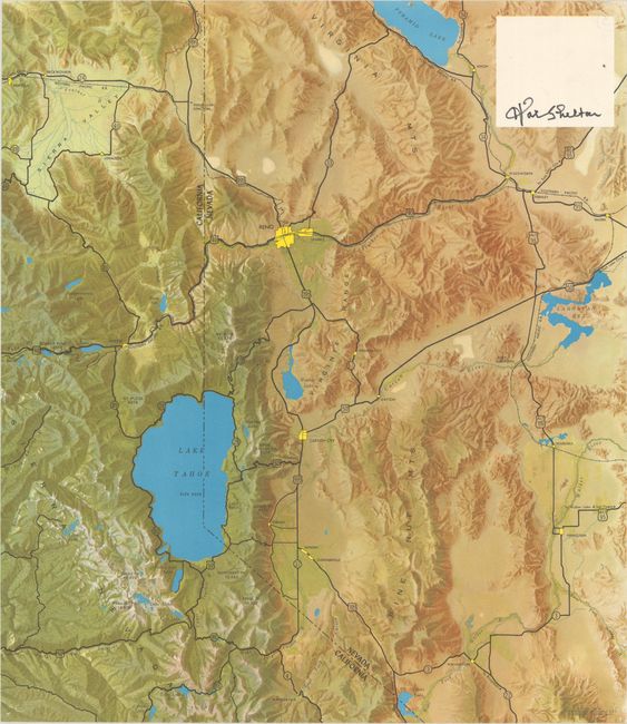
"[California-Nevada Border & Lake Tahoe]",
Subject: Lake Tahoe, California & Nevada
Period: 1953 (dated)
Publication:
Color: Printed Color
Size:
15.9 x 18.3 inches
40.4 x 46.5 cm
This untitled map by notable artist and geographer Hal Shelton is roughly centered on Lake Tahoe. It extends west to Donner's Pass and Portola in California, and east to Reno, Pyramid Lake and Yerington in Nevada. The map utilized a new technique for illustrating elevation called natural color cartography, in which the map is colored to resemble the true landscape along with shading to emphasize elevation change. This example is a rare printer's proof sent to Shelton for approval. Shelton's approval signature is located in a blank area at top right (presumably where the title would be placed).
Hal Shelton (1916-2004) worked for the U.S. Geological Survey (1938-49) before being hired by Jeppesen & Company, the leading publisher of maps for the aviation industry. In 1950, Jeppesen started publishing Shelton's natural color maps and the technique took off in popularity. Shortly thereafter, the firm licensed these maps to both Rand McNally and H.M. Gousha and continued to do so over the next two decades. In 1997, Shelton was honored by the Library of Congress as one of "the four greatest living American mapmakers."
References: Brown (IMCOS #173) pp. 18-31.
Condition: A
Clean and colorful with tiny pinholes in the corners.