"[Lot of 2] Preliminary Map of the Central Division Ft. Kearney South Pass & Honey Lake Wagon-Road... [and] Map of the Western Division of the Fort Kearney South Pass and Honey Lake Road", U.S. Government
Subject: Western United States
Period: 1857-58 (dated)
Publication: Sen. Doc. 36 or H.R. Doc. 108, 35th Congress, 2nd Session (Campbell's Wagon Roads)
Color: Black & White
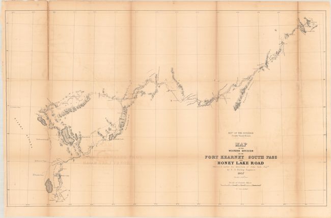
These two maps were issued in Albert Campbell's report concerning the construction of the Pacific Wagon Road from Independence, Missouri to Honey Lake, California.
A. Preliminary Map of the Central Division Ft. Kearney South Pass & Honey Lake Wagon-Road... (34.3 x 20.6"). This map is roughly centered on Bear Lake, extending from Fort Aspen and Gilbert's Trading Post in the east to City of Rocks and American Falls in the west. Salt Lake City is located at bottom. Locates numerous place names, mountain passes, etc. Names forts Hall, Piney, Thompson and Aspen.
B. Map of the Western Division of the Fort Kearney South Pass and Honey Lake Road... (35.0 x 21.4"). This map is a continuation of the first, showing the party's route from City of Rocks, past Thousand Spring Valley, Humboldt's Canyon, Fremont Canyon, Stony Point Meadows to Tutts Meadows where the Humboldt River is joined. From there the map details the region around Pyramid and Honey Lakes and south to Washoe Lake and Lake Bigler, ending at Carey's Mill at Johnson's Pass. The Proposed Road is clearly shown.
Carl Wheat devotes a chapter to the Wagon Road project, concluding "The Department of the Interior was caught up in the currents that surrounded the oncoming Civil War, and little came of the imposing wagon road program that it had set in motion. [However] its efforts were of great effect on all parts of the West."
References: Wheat (TMW) #966 & #1004.
Condition: B
Issued folding and now flattened and backed with tissue to reinforce and repair several small separations as well as a 5" fold separation at the top left of the second map. There is toning along the folds and light offsetting.