"Orbis Terrarum Tabula Recens Emendata et in Lucem Edita", Stoopendaal, Daniel
Subject: World
Period: 1729 (circa)
Publication:
Color: Hand Color
Size:
18.1 x 13.8 inches
46 x 35.1 cm
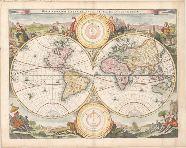
This decorative double hemisphere world map was issued in a Dutch Bible published by the Keur family. It is based on Visscher's Bible map of 1663 and is surrounded by nearly identical engravings, which include numerous exotic animals and four female allegorical representations of the continents. California is depicted as an island with a flat northern coastline labeled Nova Albion. A small island in the vicinity of Alaska is labeled Anian. In Asia, the Great Wall of China is illustrated and the northeastern coastline is severely truncated. Australia, Van Diemens Landt, and New Zealand have incomplete coastlines. New Guinea looks as if it may be attached to Australia. Tucked between the cusps of the map are astronomical diagrams illustrating the Copernican and Ptolemaic solar system theories. This is the third state, with the imprint of Pieter and Jacob Keur added at bottom center. Dutch text on verso.
References: Shirley #498; Poortman & Augusteijn #130 GII-3.
Condition: B+
A nice impression on a bright sheet, issued folding, with minor soiling that is mostly confined to the blank margins, a crease adjacent to the centerfold at bottom, and an archival repair to a tear that enters 1" into the image at right.