"[Lot of 2] Le Chili. Tire de Alf de Oualle de la C.d.I. et Divise en Treize Iurisdictions [and] [Chili]",
Subject: Chile
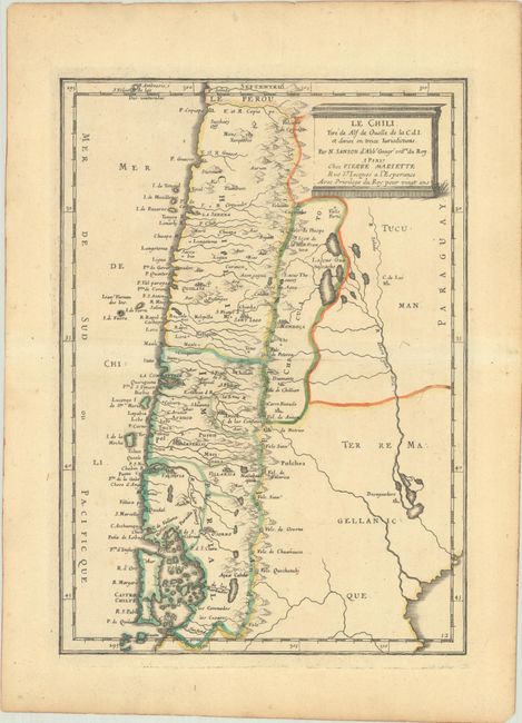
Period: 1662-1716 (circa)
Publication:
Color: Hand Color
A. Le Chili. Tire de Alf de Oualle de la C.d.I. et Divise en Treize Iurisdictions, by Sanson/Mariette, circa 1662 (7.6 x 10.8"). Fine small version of Sanson's important map of Chili showing the Cuyo provinces. The map is based on the descriptions of Alfonso de Ovalle and is completed by a graceful title cartouche. Condition: Contemporary outline color on a sheet with light toning.
B. [Chili], by Woodes Rogers, from Voyage Autour du Monde..., circa 1716 (15.6 x 7.4"). This uncommon map of the Chilean coastline extends from Santiago to south of Chiloe Island. The map features many place names along the coast, including the cities of Concepcion, Valdivia, and Castro, Fort Calbuco, and the Andes. It was published in the second volume of Voyage Autour du Monde, Commence en 1708 & Fin en 1711. Par le Capitaine Woodes Rogers, the French account of Rogers' exploits. The English sea captain Woodes Rogers (ca. 1679-1732) was recruited by William Dampier to embark on a privateering expedition against Spanish ships. The voyage, which lasted from August 1708 to October 1711, circumnavigated the globe and successfully captured several Spanish ships in the Pacific. But the voyage is perhaps best known for the rescue of castaway Alexander Selkirk on Juan Fernandez Island (noted on the map here), the inspiration for Daniel Defoe's Robinson Crusoe. Condition: A fine impression issued folding, now flat, with a few small spots, a printer's crease at top center, and a binding trim in the left blank margin that has been replaced with old paper.
References:
Condition: B+
See description above.