"[Lot of 2] Nevada Tourist Highway Map [and] Lake Tahoe California - Nevada", Eddy, Gerald
Subject: Nevada & Lake Tahoe
Period: 1960-65 (circa)
Publication:
Color: Printed Color
Size:
18.1 x 22.6 inches
46 x 57.4 cm
This lot features two pictorial maps by Gerald Eddy:
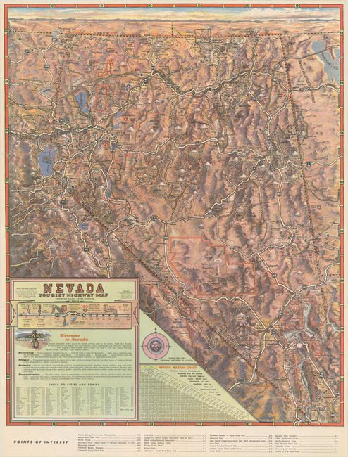
A. Nevada Tourist Highway Map, circa 1960 (18.1 x 22.6"). This distinctive topographical map emphasizes the highway network and was produced for the State of Nevada Department of Highways. A legend at lower left further identifies railroads, national parks, national forests, Indian Reservations, and “Bombing and Gunnery Range Danger Areas.” It features a mileage chart for Nevada cities and points of interest in the bottom margin. The verso is filled with related illustrations and titled “Nevada Recreation Unlimited.” Condition: Issued folding with a couple of tiny splits at the fold junctions.
B. Lake Tahoe California - Nevada, dated 1965 (22.9 x 16.9"). This attractive and detailed bird's-eye view depicts the Lake Tahoe region, extending to Truckee, Reno, Virginia City and Carson City. The rugged topography of the region is presented with a three-dimensional quality and locates numerous ski areas, golf courses, casinos, mountain peaks, and the road network to access these recreational features. Text at bottom calls the region an "All-Year Playland." Blank verso. Condition: Bright color on a glossy sheet, which has been stored rolled and does not lay flat on its own.
References:
Condition: A
See description above.