"[Lot of 2] Colorful Colorado Invites All America to Enjoy Healthful Climate - Varied Resources - Superb Scenery and Recreation [and] Through the Scenic Wonderland of Denver's Mountain Parks",
Subject: Colorado
Period: 1942-49 (dated)
Publication:
Color: Printed Color
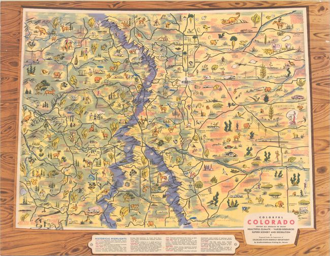
A. Colorful Colorado Invites All America to Enjoy Healthful Climate - Varied Resources - Superb Scenery and Recreation, by Bradford-Robinson Printing Co., dated 1949 (22.1 x 17.2"). This promotional brochure was one of a series issued by the Colorado State Highway Department in the 1940s and 50s and contains a large pictorial map of "Colorful Colorado." Joe Barros, who later worked as the head illustrator at The Denver Post for three decades, designed this edition. It is filled with small illustrations emphasizing the state's history, natural resources, and recreational activities including hiking, fishing, hunting, and more. Historical highlights are listed below the map. Other elements within the brochure include a map of the state's highway system (21.3 x 16.6"); smaller maps showing the connecting routes through Denver, Grand Junction, Colorado Springs, and Pueblo; a mileage table; Kodachromes of various sites; and text on points of interest in the state. Self-folding. Condition: Issued folding. Main pictorial map is in very good condition with a small wormhole in the border. There are some small abrasions elsewhere in the brochure and minor wear and a few short splits along the folds.
B. Through the Scenic Wonderland of Denver's Mountain Parks, by Denver Convention and Visitors Bureau, dated 1942 (16.8 x 10.9"). This wonderful pictorial map extends from Loveland Basin east to Denver and from Boulder south to Shaffers Crossing. Images of skiing, outdoor recreation, wildlife, and more pepper the landscape. A key identifies prospectors trails, highways and other roads, nation forest areas, trails, and state highway markers. Various peaks are named along with their elevation. The map is surrounded by ten vignettes, with summer activities on the left and winter activities on the right. Signed "F. F." and dated May 1942. Self-folds into brochure with an illustrated cover and the title "Adventure Map Prospectors Trail Through Denver Mountain Parks to the 14 260 Ft. Summit of Mt. Evans." Printed by Smith-Brooks Printing Co. in Denver. Condition: Issued folding with minor wear along the folds.
References:
Condition: A
See description above.