"[Lot of 2] Automobile Highways North Bay Counties - Served by Sears Point Toll Road [on sheet with] Automobile Highways, East Bay Counties - Served by Sears Point Toll Road [and] Road Maps - Pacific Coast Highways",
Subject: California
Period: 1928-29 (dated)
Publication:
Color: Printed Color
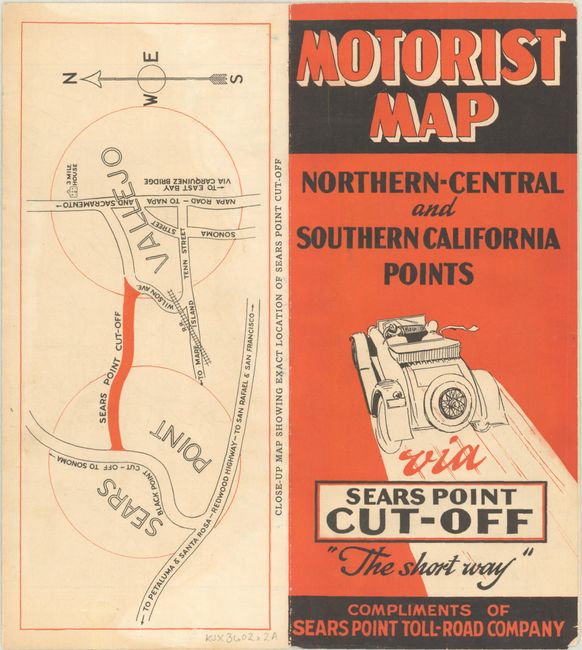
A. Automobile Highways North Bay Counties - Served by Sears Point Toll Road [on sheet with] Automobile Highways, East Bay Counties - Served by Sears Point Toll Road, by Kerns, Egbert & Vaughn, dated 1929 (16.4 x 10.8"). This pamphlet contains two maps for the Sears Point Toll Road, linking Sears Point with Vallejo and thereby cutting off significant travel time from using other state routes. The verso contains a full-page description of the advantages of using the new toll road. The toll road was in operation from 1928 to 1938 when it became a state highway. A proposal recently was introduced to expand the highway and reestablish it as a toll road. Click here to read more. Condition: The paper is slightly rippled with some minor color bleed-through on the left-side map. (B+)
B. Road Maps - Pacific Coast Highways, by the American Toll Bridge Co., dated 1928 (15.5 x 17.8"). This brochure features highway maps of California, Washington and Oregon as well as a number of strip maps highlighting various routes between cities. The company’s two toll bridges over the San Joaquin River are shown in an inset at top right. The State of California assumed ownership of these bridges in 1940. Only two examples were located on OCLC. Condition: There are a few neat old tape repairs along the folds on recto with some minor loss of image. (B)
References:
Condition:
Issued folding. See description above for details.