"[Map in Report] Provisional Geological Map of Part of the Chippeway Land District of Wisconsin with Part of Iowa & of Minnesota Territory [in] Letter of the Secretary of the Treasury ... a Report of Reconnaissance of the Chippewa Land District...", Owen, David Dale
Subject: Upper Midwestern United States
Period: 1848 (published)
Publication:
Color: Hand Color
Size:
25.5 x 34.2 inches
64.8 x 86.9 cm
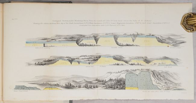
This early geological survey extends from Prairie du Chien (here also Fort Crawford and Kipy Saging) north along the Mississippi River to the Minneapolis area and beyond to Duluth. The eastern range includes the rapids along the northern reaches of the Wisconsin River. A legend at lower right explains the use of color to indicate twelve different geological types. This map was prepared to illustrate David D. Owen's report on his geological reconnaissance. Owen and his staff were reported to have worked 12-15 hours every day during the summer and winter of 1847 for this notable survey. The map is still bound in the 134-page report, which also includes 23 lithographed plates, 13 colored and 1 uncolored geological sections. Hardbound in modern gray cloth with paper title label on spine.
References:
Condition: B+
The folding map has some scattered foxing mostly at upper left, a 2.5" edge tear at left that has been archivally repaired on verso, and some extraneous creasing also at left. Text and other plates have some scattered foxing. Modern binding has minimal wear.