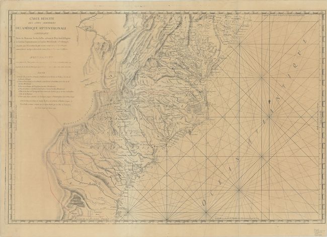
"Carte Reduite des Cotes Orientales de l'Amerique Septentrionale Contenant Partie su Nouveau Jersey, la Pen-sylvanie, le Mary-land, la Virginie, la Caroline Septentrionale, la Caroline Meridionale et la Georgie…", Sartine
Subject: Mid-Atlantic & Southeast United States
Period: 1799 (dated)
Publication:
Color: Hand Color
Size:
33.3 x 22.5 inches
84.6 x 57.2 cm
This is the later Italian re-engraving of this large, handsome, and important Revolutionary War chart. It was originally published by the Depot de la Marine for the French fleet when the focus of the war shifted to the south. The chart extends from Delaware Bay and Philadelphia south through much of Georgia to Amelia Island and St. Johns River. It provides excellent detail along the coast, particularly in Chesapeake Bay. Surprisingly, it also provides great detail inland to the Appalachians and extends west to Fort Necessity and the Ohio River in Western Virginia. The map shows early county names throughout the region, as well as early roads, Indian tribes, towns, mountains, and rivers. Numerous native tribes are noted and the location of the Catawba Indians Catawbaw Town is shown south of Charlottesburg (Charlotte, NC). Two Quaker meeting houses are shown east of Salem, NC. Engraved in Rome by Giovanni Brun.
References:
Condition: B
A crisp impression on thick, bluish paper that is toned with light offsetting, minor soiling, and a long printer's crease at left.