"[2 Volumes] The British Colonies; Their History, Extent, Condition and Resources", Martin, Montgomery
Subject: Canada
Period: 1851 (circa)
Publication:
Color: Hand Color
Size:
7.8 x 11.4 inches
19.8 x 29 cm
The maps from The Illustrated Atlas were first published in serial form to a target audience that led insular lives due to the expense and hardship of travel. All that changed as the progress of the nineteenth century brought swift and dramatic changes in public awareness of far away places. Tallis' maps no doubt played an important role in this dramatic awakening. These maps not only provided up-to-date geographical knowledge, but also used vignette views within the map's design to show the native people and their occupations, cities and points of interest. The maps hark back to a cartographic tradition from the Dutch mapmakers of the seventeenth century with finely engraved decorative borders. The maps were drawn and engraved by John Rapkin with views drawn and engraved by a number of prominent artists. The maps were issued as a complete volume from 1851 until about 1865. Some of the maps were also published in other history books published by Tallis including British Colonies and, without the vignettes, in geographical dictionaries and encyclopedias until about 1880.
Published by the great John Tallis and edited by Robert Montgomery Martin, these two volumes cover Canada and provide detailed information on the history, topography, geology, government, population, industry, and trade. The volumes are finely illustrated with 7 steel engraved portraits, 4 maps, and a fine title page. The portraits are surrounded in delicate fancy borders and include Queen Elizabeth, Sir Walter Raleigh, Francis Bacon, Queen Anne, Prince Rupert, William Pitt, and Sir Francis Drake. The maps are beautifully engraved by John Rapkin, each with several interesting vignettes. 360 pages across two volumes. Hardbound in blind- & gilt-stamped red cloth. The maps are as follows:
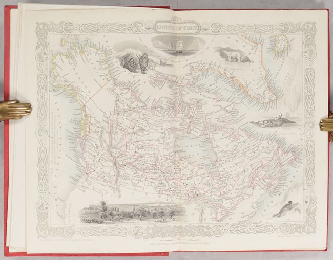
A. British America extends to show all of today's Canada and Alaska, here called Russian America. In Canada, at least 23 districts are outlined. This edition includes a bird's-eye view of Montreal, a seal, whale fishing, Eskimos (here called Esquimaux), polar bears, and a nautical scene showing the ships Fury and Hecla, which made expeditions to the Arctic in search of the Northwest Passage under William Edward Parry. The illustrations are by H. Warren and engraved by Robert Wallis.
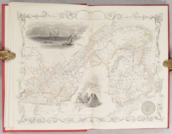
B. East Canada and New Brunswick shows the St. Lawrence River and New Brunswick. There are two large vignettes: a group of North American Indians, and a lovely view of Quebec with numerous sailing ships and boats in the foreground. The seal of Canada appears at bottom right. The illustrations are by H. Warren and engraved by J.B. Allen.
C. West Canada West Canada covers the region of present-day Ontario and includes uncolored vignettes of Niagara Falls, an Indian encampment, and Kingston. The illustrations are by H. Warren and engraved by Robert Wallis.
D. Nova Scotia and Newfoundland also shows parts of New Brunswick and Labrador. The map includes vignettes of Halifax, steam and sailing ships in the cod fishery off Newfoundland, the seals of both provinces, and a pair of dogs with barrels and an anchor. The decorative border features ice and fish caught on fishing lines. Illustrations drawn by A. Fussell and engraved by J. Rogers.
References:
Condition: A
The maps are clean and bright with contemporary outline color. Text and plates are also near fine, with only a bit of foxing to a couple of the portraits and a few pages starting to come loose from the binding near the front of Volume I. Spines sunned, else covers are very good.