"Atlas Antiquus Danvillianus. Conspectus Tabularum Geographicarum...", Anville, Jean Baptiste Bourguignon d'
Subject: Atlases
Period: 1784 (published)
Publication:
Color: Hand Color
Size:
16.1 x 22.9 inches
40.9 x 58.2 cm
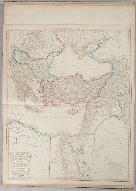
This atlas of the ancient world includes 12 copper-engraved maps, 9 of which are double-page. Of particular interest are the two double-page maps of Orbis Romani which show the full extent of the Roman Empire. The maps cover the area from Britain east to India and part of Southeast Asia and contain very good detail of towns, cities, rivers and topography. The complete list of maps include:
Orbis Veteribus Notus
Orbis Romani, Pars Occidentalis
Orbis Romani, Pars Orientalis
Gallia Antiqua
Tabula Italiae Antiquae
Graeciae Antiquae
Asiae quae vulgo Minor Dicitur et Syriae
La Palestine
Aegyptus Antiqua
L'Euphrate et le Tigre
Ad Antiquam Indiae Geographiam Tabuls
Germaniae, France, Italiae, Espagne, Isles Britanniques
The maps are based on the work of Jean Baptiste Bourguignon d'Anville. Published by Schneider & Weigel. Elephant folio. Hardbound in quarter tan leather with tips over marbled paper-covered boards.
References:
Condition: B+
The maps are in very good condition with light soiling and dampstains in the top corners of the sheets. The title page is moderately soiled with a previous owner's stamp at bottom right. Covers are worn and stained with bumped corners. The spine is heavily worn and stained with tears and chips at top and bottom.