"[Lot of 2] No. 5. That Part of Disturnell's Treaty Map in the Vicinity of the Rio Grande and Southern Boundary of New Mexico Referred to by U.S. Surveyor... [and] Mexican Boundary B. Extract from the Treaty Map of Disturnell of 1847...", U.S. Government
Subject: Southwestern United States & Mexico
Period: 1851 (dated)
Publication:
Color: Black & White
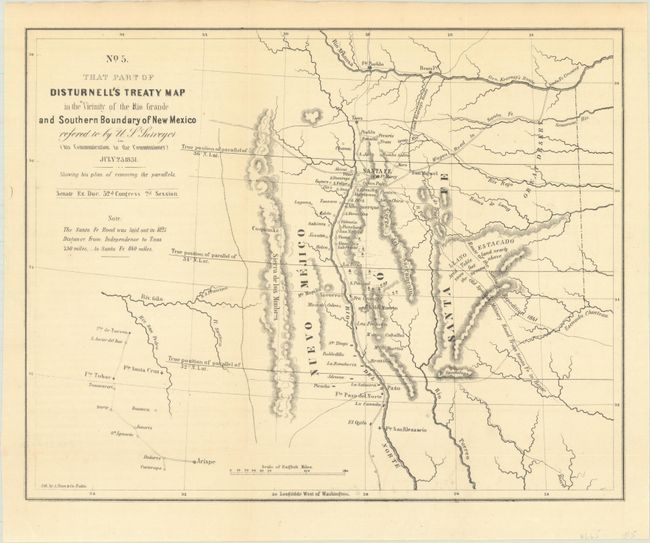
A. No. 5. That Part of Disturnell's Treaty Map in the Vicinity of the Rio Grande and Southern Boundary of New Mexico Referred to by U.S. Surveyor..., from Sen. Ex. Doc., 32nd Congress, 2nd Session, (10.9 x 8.6"). This is a fascinating map centered roughly on Santa Fe. The map covers the area from the Arkansas River south to the 31st parallel and locates Albuquerque and Tucson. The parallels were being corrected from an incorrect position previously mapped, and this map illustrates both old and new parallels. Shows topography, hydrology, Gen. Kearny's route, the route of the Santa Fe Expedition, the old Spanish military road, among other interesting items. It was one of the key maps in the Bartlett correspondence regarding the dispute over the survey of the Mexican border. References: Koepp, CIS 626, map #4; Wheat (TMW) #720.
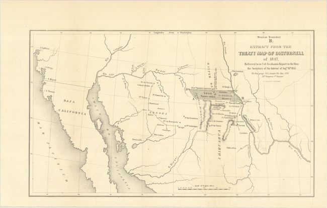
B. Mexican Boundary B. Extract from the Treaty Map of Disturnell of 1847. Referred to in Col: Graham's Report to the Hon: the Secretary of the Interior of Augst. 16th 1851, from Senate Ex. Doc. 119, 32d Congress, 1st Session, (15.5 x 9.1"). This map was created by James Graham to illustrate the boundary differences that resulted in a disputed 5,950 square mile region that was strategic to mining and railroads. It depicts a large shaded region in dispute as a result of a major error in the Disturnell map referenced in the Treaty of Guadalupe Hidalgo. The error was discovered when the American commissioner (John Russell Bartlett) and Mexican commissioner (General Pedro Garcia Conde) began the actual survey work for the southern boundary. Specifically, they discovered that Disturnell's map put the Rio Grande two degrees too far to the west and El Paso was placed about 30 miles too far north. The resulting 5,950 square mile error became a political and economic issue for both sides. The land itself was rich in minerals and, for the United States, was the only practical route for a southern transcontinental railroad. The issue was eventually resolved by the inclusion of the disputed area in the Gadsden Purchase, whereby the United States took over this disputed territory (along with other lands) in exchange for a cash payment. References: Martin & Martin, plt #40; Wheat (TMW) #718.
References:
Condition: A
Issued folding with a hint of offsetting.