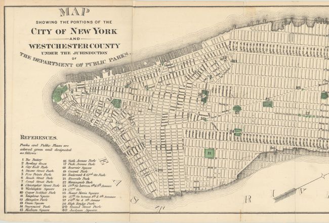
Map Presents the Scope of Newly Created New York Department of Public Parks
"Map Showing the Portions of the City of New York and Westchester County Under the Jurisdiction of the Department of Public Parks",
Subject: New York City, New York
Period: 1870 (circa)
Publication:
Color: Hand Color
Size:
49.3 x 8.9 inches
125.2 x 22.6 cm
An attractive and detailed map by William Grant, Chief Engineer, that extends from the southern tip of Manhattan northeast to Yonkers. It presents the street-grid pattern of the city, the New York Harlem & Albany Rail Road, Croton Aqueduct, and numerous docks and parks, including the large Central Park at center. A key at lower left numbers 30 parks and public places which are also highlighted in green on the map.
The map was produced by the new Department of Public Parks, established by the corrupt Boss Tweed Ring after firing the Board of Commissioners of Central Park and the park's original designers. The Departments of Public Works and Public Parks were the principal vehicles for the Tweed Ring to siphon off funds by tripling the city’s debt for projects and obtaining kickbacks from conspiring contractors. The corruption was exposed in 1871, but the Department of Public Parks continued under new management.
We found no past sales records for this map and only 7 institutional examples on OCLC.
References:
Condition: B+
Issued folding on a clean sheet with faint offsetting and numerous fold separations that have been skillfully closed on verso with archival tape.