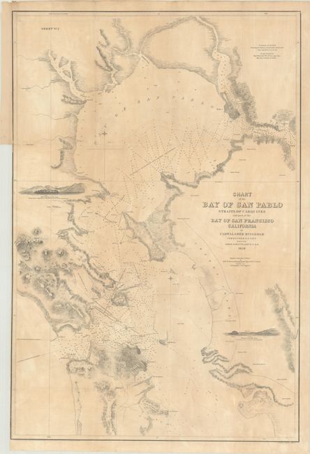
"Chart of the Bay of San Pablo Straits of Carquines and Part of the Bay of San Francisco California", Ringgold, Cadwalader
Subject: San Francisco Bay, California
Period: 1850 (dated)
Publication:
Color: Black & White
Size:
20.6 x 30.5 inches
52.3 x 77.5 cm
This uncommon Gold Rush-era chart extends from Golden Gate north to San Pablo Bay and is filled with navigational aids including soundings, shoals and bottom types. The chart presents the rugged topography of the coastlines and provides approach views of Pt. Smith and Marin Island. The early street-grid pattern of San Francisco, Vallejo and Benicia are well depicted.
Naval Commander Ringgold was charged with producing the first detailed survey of the region - a task that became especially important with the recent discovery of gold. Ringgold received financial support from local citizens to expand the scope of his charge and reduce the risks of navigation. His groundbreaking work included especially detailed surveys along the rivers that also showed new settlements. Ringgold sought publication of his work by the federal government, but during a period of intense rivalry between the Coast Survey and Navy, Senator Jefferson Davis questioned the accuracy of Ringgold’s survey and his request was denied. As a result, Ringgold’s charts and report were privately printed. For an excellent summary of the importance of Ringgold’s work during the Gold Rush, click here.
References:
Condition: B
Issued folding and backed on linen with a binding trim at left. There is light toning and a short fold separation at upper left that has been closed on verso with archival tape.