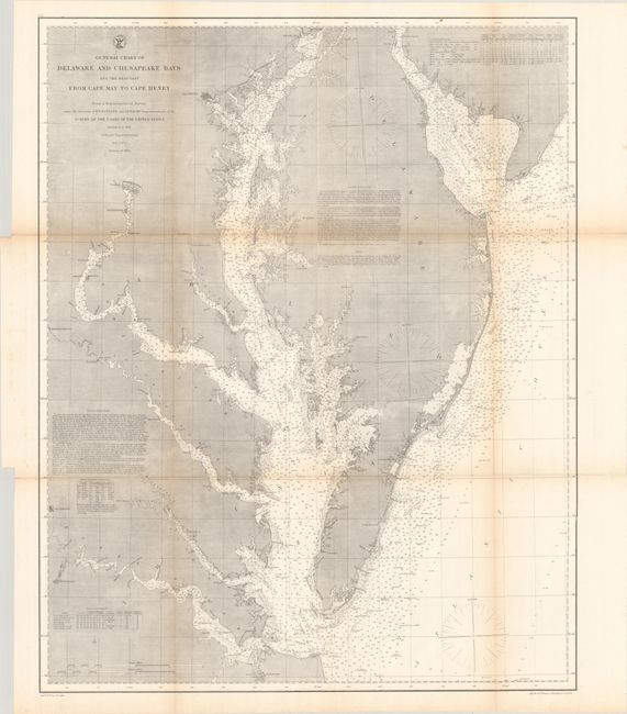
"General Chart of Delaware and Chesapeake Bays and the Seacoast from Cape May to Cape Henry", U.S. Coast Survey
Subject: Chesapeake Bay
Period: 1866 (dated)
Publication:
Color: Black & White
Size:
24.5 x 30.9 inches
62.2 x 78.5 cm
The Office of Coast Survey is the oldest U.S. scientific organization, dating from 1807 when Congress directed that a "survey of the coast" be carried out. By 1836, it was called the U.S. Coast Survey and in 1878, the name was changed to the U.S. Coast and Geodetic Survey. Today the Office of Coast Survey is a division of the National Oceanic and Atmospheric Administration NOAA.
The survey teams, composed of civilians as well as Army and Naval officers, charted the nation's waterways and produced a wide array of reports, survey charts, hydrographic studies of tides and currents, astronomical studies and observations, and coastal pilots. These charts are an important record of the changing nature of the nation's coastlines. In additional to coastal charts, the U.S. Coast and Geodetic Survey produced land sketches, Civil War battle maps, and the early aeronautical charts.
A very detailed chart of the Chesapeake Bay extending from Norfolk to Havre de Grace, issued shortly after the conclusion of the Civil War. The chart extends west to include portions of the James, Rappahannock, and Potomac rivers and east to include part of Delaware Bay up to Port Penn. It features extensive navigational information including soundings, bottom types, tides, sailing directions and much more. The chart was first completed in 1855 and updated here to 1866.
References:
Condition: A
Issued folding on a clean sheet with a hint of toning along the fold lines.