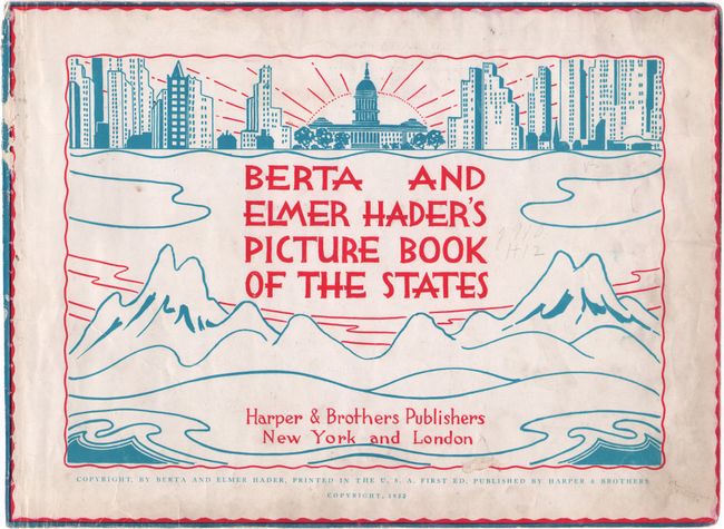
"Berta and Elmer Hader's Picture Book of the States", Harper Bros.
Subject: United States, Atlases
Period: 1932 (published)
Publication:
Color: Printed Color
Size:
12.4 x 9.3 inches
31.5 x 23.6 cm
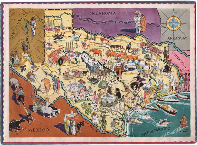
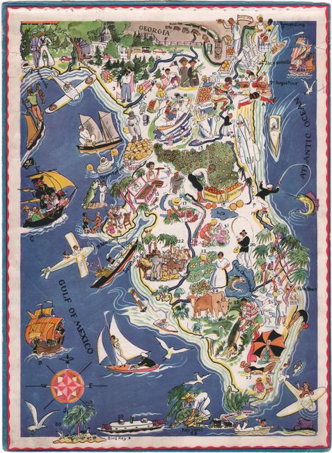
This remarkable book is filled with pictorial maps of 46 of the 48 states (on 27 sheets - missing the map of Maryland, Delaware and Washington, DC) with a page of descriptive text keyed to the illustrations. Most of the maps show two states, but Texas, California, Michigan, Florida, Virginia, New York, Massachusetts, and Maine have their own page. Each map is fully illustrated in a fanciful and quaint style reminiscent of the times. The text adjacent to each map outlines the early history and facts about each state. This book is rarely found whole as they are often broken up and sold as individual maps. Hader is probably best known for his dust cover illustration for Steinbeck's The Grapes of Wrath.
At the back of the book is a message from Angelo Patri, whose words speak true to map lovers everywhere: "The teacher mounted a chair and untied a string. With a rattling flop a picture map rolled down and my heart jumped up. Never had I seen anything so beautiful. Never since have I seen anything that gave me such a lift. I cannot tell you why. That map spoke to me in a language I knew and could answer [...] I learned most of my history from maps. You see, that old picture map had given me the notion that behind every black line that said 'river' was a story that said 'people,' and I had a keen nose for a story."
First edition, published by Harper & Brothers. This example is disbound with each page separated and is accompanied by the original blue cloth covered boards. Map of Maryland, Delaware, and Washington D.C. is lacking, which includes the text for the map of Virginia on verso. The back free-endpaper is also lacking.
References:
Condition:
The maps are all loose and disbound from the covers. The majority of the maps are in very good (B+) condition with light soiling, creasing along the edges, and occasional small chips and tears along the edges. The map of New York has a chip at top right. The map of Washington and Oregon has been torn into two pieces and reattached with cello tape, which has caused staining; the cello tape has been removed and the map has been reattached again with archival tape, although the old tape residue remains. The title page and front free-endpaper have abrasions. The covers are heavily worn with bumped corners, and the printed title is barely visible along the spine.