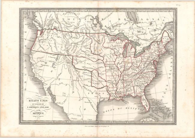
"Etats Unis et Partie de l'Amerique Anglaise et du Mexique Corriges et Augmentes", Anon.
Subject: United States, Republic of Texas
Period: 1836 (circa)
Publication:
Color: Hand Color
Size:
13.9 x 10.4 inches
35.3 x 26.4 cm
This map presents U.S. states in the eastern half and Indian districts in the West including the Sioux, Mandan, and Osage districts. The map was issued circa 1836 with Arkansas shown as a state (1836) but Michigan as a territory (achieved statehood in 1837). The Southwest is controlled by Mexico, though Texas is named and has an early uncolored border indicating it had just declared independence. Within Texas, Austin, San Felipe de Austin, Houston and Nacogdoches are named. The Great Basin has pre-Fremont features with several spurious rivers flowing to the Pacific. The Northwest is Oregon District with a somewhat meandering border that roughly follows today's boundary. There is no attribution, though the editor is noted as Dopter below the bottom border.
References:
Condition: B+
There is scattered foxing that is predominantly in the blank margins. A short centerfold separation is confined to the bottom blank margin.