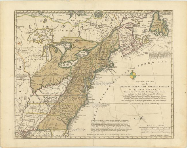
"Nieuwe Kaart van de Grootbrittannische Volkplantingen in Noord America waar in Tevens de Fransche Bezittingen en de Landen...", Tirion, Isaac
Subject: Colonial Eastern United States & Canada
Period: 1755 (dated)
Publication: Nieuwe en Beknopte Hand Atlas
Color: Hand Color
Size:
17.8 x 14.4 inches
45.2 x 36.6 cm
This is a handsome illustration of the British and French possessions at the beginning of the French and Indian War. It is a very detailed map of the disputed region between the Mississippi River and the Appalachian and Allegheny Mountains, which is graphically depicted and delineated by a dashed line for the French claims and a dotted line for the British claims. The frontier forts of both nations are located, as are colonial settlements and Indian villages. The imaginary islands in Lake Superior are evident, including I. Philippeaux, Ponchartrain, and St. Anne. The map was based on information from John Mitchell's great map of North America. Despite the 1755 date, McCorkle claims that the map first appeared in 1769 in Nieuwe en Beknopte Hand-Atlas. However, we have found examples of the map in Tirion's Hedendaagsche Historie, of Tegenwoordige Staat van Groot Brittannie, a two-volume set that was published in 1754-55.
References: McCorkle #755.39 &769.1; Sellers and Van Ee #63.
Condition: B+
Full contemporary color on paper with a Strasbourg Lily watermark. There is light color offsetting, a few spots of foxing, and a short centerfold separation at bottom that has been closed on verso with archival tape.