"[Lot of 5] Orbis Terrae Compendiosa Descriptio... [and] America [and] Asia [and] Africa [and] Europa", Magini, Giovanni Antonio
Subject: World & Continents
Period: 1597 (published)
Publication: Geographiae Universae
Color: Hand Color
This is a matching set of maps of the world and continents, printed in Cologne by Petrus Keschedt. Magini published a new edition of Ptolemy's Geography as Geographiae Universae in 1596 with copperplate maps engraved by Girolamo Porro. Keschedt copied these maps onto newly engraved plates and republished the volume the following year. Although Keschedt credited Magini as the author, it is believed that he published the volume without Magini's knowledge or consent. Included in this lot are:
A. Orbis Terrae Compendiosa Descriptio ex ea, quam ex Magna Universali Mercatoris... (9.5 x 6.0"). This intricately engraved double-hemisphere map was based on Rumold Mercator's 1587 world map and was re-engraved in a reduced format by Girolamo Porro. The amount of detail that has been retained from the larger map is astonishing. The map is surrounded by an elaborate strapwork border, and an armillary sphere and 32-point compass rose are tucked between the hemispheres. The North Pole is depicted as a landmass surrounding a sea from which four rivers radiate and there is a well depicted Northwest Passage. The huge Terra Australis is shown as a part of Tierra del Fuego, and the lands of Lucach, Maletur and Beach (from the travel account of Marco Polo) are noted along the coast in the vicinity of present day Australia with a large island labeled Iava Minor located in the same region. Japan is shown in a kite-shaped configuration, with the fictitious Satyrorum Insule (Satyr's Island) shown above. South America has a bulge on its southwest coast, and New Guinea is depicted in a large, circular configuration. The map embodies many ancient authorities and is a wonderful view of classical cartography. Reference: Shirley #194.
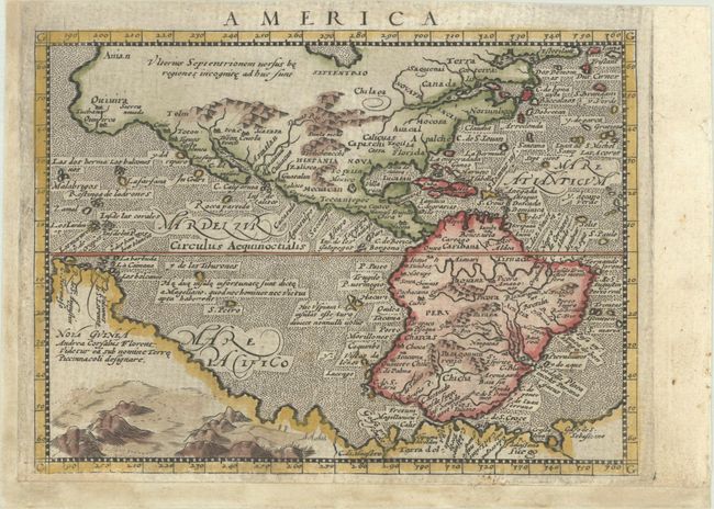
B. America (6.7 x 4.9"). This finely engraved map is derived from Giovanni Lorenzo d'Anania's 1582 map of the Americas and further based on the geography of Ortelius. Most notable is the characteristic bulge to the west coast of South America and the huge Southern Continent that attaches to Nova Guinea. Anian and Quivira appear on North America's bulbous western coast. Reference: Burden #97.
C. Asia (6.6 x 4.9"). This map is based on Ortelius' map of the continent, with the exception of the addition of a strait dividing the southern portion of the Malay Peninsula. Reference: Yeo #14.
D. Africa (6.8 x 4.9"). This small map of Africa and the Arabian Peninsula shows part of Brazil as well. The rivers of central and north Africa feature prominently including the Ptolemaic concept of the origin of the Nile in two lakes south of the Equator. The largest of these lakes also has a river flowing southeast. The sea is stipple engraved with a tiny sea monster and decorative calligraphy. Reference: Betz #35.
E. Europa (6.8 x 4.9"). This small map of Europe contains good detail for its size. There are numerous place names along with rivers and mountains depicted. The map extends to include Iceland and Greenland, the latter of which is shown very close to the northern coast of Norway.
References:
Condition: B+
The maps have nice impressions with very light soiling and professional repairs to separations along the centerfolds. The maps of Asia and Europe have been trimmed to the neatline at left and professionally remargined. Each of the 4 continent maps has several margins extended to accommodate framing. The world map has some tiny chips in the bottom margin that have been professionally repaired, with a small amount of the text below the map expertly replaced in facsimile.