A Pocket Atlas for Ladies with 28 Maps
"[2 Volumes] Bibliotheque Universelle des Dames. Premiere Classe. Atlas", Laporte, Joseph de
Subject: Atlases
Period: 1786 (circa)
Publication:
Color: Black & White
Size:
3.3 x 5.1 inches
8.4 x 13 cm
This delightful miniature atlas was created for ladies to carry with them in their travels and assist them in understanding the world around them. However, as the brief introduction explains, the bare minimum of words were used in the atlas so as not to confuse or overwhelm the reader with definitions, nomenclature, or terminology. The atlas contains the same 28 maps as in Laporte's Atlas Moderne Portatif, but folded into a smaller format. This complete atlas devotes a larger than usual number of maps to regions outside of Europe. The maps focused on the Americas include a map of North America, South America, the Gulf of Mexico, New England, Virginia and Maryland, and Jamaica. Maps of the world, celestial sky, continents, and regional maps of Europe are also included. Although most of the maps measure around 8.8 x 7", there is also a larger folding map of France that measures 13 x 10.5. In addition to the maps, the atlas features a lovely armillary sphere plate and 2 unnumbered plates containing astronomical charts. Another interesting feature is that each volume includes a legend that has been cut out and pasted onto the front free-endpaper to identify the symbols and abbreviations used in the maps.
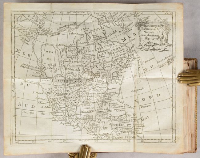
The map of North America, L'Amerique Septentrionale Divisee en ses Principaux Etats, shows the imaginary Mer de l'Ouest and a Northwest Passage stretching from Baffin Bay to the Archipel St. Lazare. There is not yet any sign of a recognizable Alaska. The British colonies are confined on the eastern seaboard with the huge French Louisiana territory stretching to the Pacific Northwest. Ft. Cenis is located in present-day Texas, and Habitations de Francois refugies appear above Charleston. The simple title cartouche features two Native Americans. The map is apparently based on Janvier's map of the same title.
The map of Virginia and Maryland, Carte de la Virginie et du Mariland, exhibits some very odd boundaries. Maryland is an ill-defined wedge between Virginia and Pennsylvania and does not extend beyond the Appalachians. Maryland's most prominent settlement is St. Marie, the colony's first capital. The Delaware boundary indicated on the map was made following the conclusion of a long land dispute between Lord Baltimore and the Penn family in 1760. Strangely, Philadelphia is missing from the map while Alexandria is also called Belhaven. The colonies are labeled Possessions Angloises, and Louisiane is clearly marked on the western slope of the Allagany Montagnes. There is not a great deal of detail, but there are some interesting names including the Tabaco Montagnes.
Two volumes; 24mo; 28 maps and 3 plates. Hardbound in full contemporary mottled calf with gilt dentelle on covers, gilt tooling and titling on spines, and marbled endpapers.
References: McGuirk #168, #169.
Condition: A
The maps are clean and bright with occasional light offsetting, minor toning, or misfolds. The edges of some of the maps are creased as they stick out of the volume a bit. There is a previous owner's stamp on the inside front covers. The covers have bumped corners and a few tiny abrasions. The spines are cracked along the edges and have a few small worm tracks.