First Plate with Full Contemporary Color
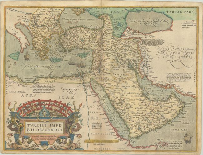
"Turcici Imperii Descriptio", Ortelius, Abraham
Subject: Eastern Mediterranean & Middle East
Period: 1572 (published)
Publication: Theatrum Orbis Terrarum
Color: Hand Color
Size:
19.8 x 14.9 inches
50.3 x 37.8 cm
This is Ortelius' first map of the Turkish Empire that appeared in his monumental atlas only between 1570 and 1579, after which the copperplate was replaced with a similar map of the same title. The map is based on Ortelius' own map of Asia, which was derived from the work of Italian mapmaker Giacomo Gastaldi of 1561. It features the Arabian Peninsula prominently and illustrates the coastlines fairly well but most of the interior information is completely hypothetical with many place names taken from antiquity and legend. The Red Sea (Mare de Mecca) is shown relatively accurately whereas the Persian Gulf (Mare Elcatif) is misshapen due to the exaggerated Arabian shoreline. The map is richly embellished with sailing ships, a sea monster in the Black Sea, and a superb, strapwork title cartouche topped by a grape arbor and supported by a pair of female, winged sea monsters. German text on verso.
References: Ankary #16; Tibbetts #35; Van den Broecke #168.
Condition: B+
A nice impression with full contemporary color on a sturdy sheet with light soiling, a bit of toning along the centerfold, and archival repairs to centerfold separations at top and bottom.