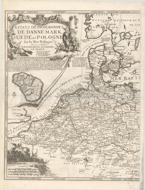
"[On 2 Sheets] Estats des Couronnes de Dannemark, Suede, et Pologne sur la Mer Baltique...", Fer, Nicolas de
Subject: Central & Eastern Europe
Period: 1705 (dated)
Publication:
Color: Black & White
Size:
13.9 x 17.3 inches
35.3 x 43.9 cm
This is De Fer's two-sheet map of northern Europe, extending from Paris through the Baltic states and over to Smolensk and Braclaw. Major trade routes, both on sea and land, are traced throughout the map. Herman van Loon engraved this beautiful map and richly embellished it with three cartouches. The primary title cartouche fills the upper-left corner with scenes of war and victory, and below that is an inset map of Hven Island, the location of Tycho Brahe's observatory. In the opposite corner is a secondary title cartouche Carte des Estats de Suede, de Dannemarq, et de Pologne; sur la Mer Baltique… flanked by a bear at left and a galloping horse at right. The scale of miles cartouche is festooned with wind heads blowing strong, wintry winds. The coordinates for major cities are noted within the borders.
References:
Condition: B+
Nice impressions on bright sheets with bunch of grapes watermarks and light soiling. There are professional repairs to three tears that enter the image and the left-hand sheet has been professionally remargined at bottom left. The first image is a composite image - the map is in two separate sheets.