"[Map in Report] Chart of the West Indies the Isthmus of America and Lines of Proposed Steam Mail Communication [in] Home Squadron ... Report: The Committee on Naval Affairs...",
Subject: Gulf of Mexico & Caribbean
Period: 1841 (published)
Publication: Rep. No. 3, 27th Congress, 1st Session
Color: Black & White
Size:
12.9 x 8.1 inches
32.8 x 20.6 cm
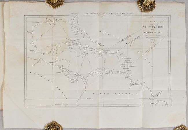
This map was drawn by James McQueen and presents the Gulf Coast region extending through Central America and northern South America east to the West Indies. It shows the proposed British mail routes throughout the region with “The Royal Mail Steam Packet Company” noted above the top border. The map accompanies an 1841 U.S. government report on “Home Squadron,” which warned of the danger of so many British steamships in the vicinity of the U.S. that could easily be converted for use in war. The report includes the complete contract with the British government for the mail service. It accompanied a bill to provide for the U.S. Navy to establish a similar capability to counteract the perceived threat of the British steamers. The Royal Mail Steam Packet Company was very successful and became the largest shipping line in the world. This map is identical to one published by Arrowsmith, but lacks the Arrowsmith attribution below the map. No examples of this map (or the Arrowsmith version) appear in OCLC by name, though seven institutions hold the report. The 22-page report has never been bound and has its original string ties.
References: Claussen & Friis #393.
Condition: B
The folding map has light dampstains in the upper portion of the image and a bit of scattered foxing in the top blank margin. Disbound text is mostly clean with a little roughness along the edges and some soiling and staining on the first and last page of the report.