"[Lot of 2] Map of Texas and Indian Territory [and] Tunison's Texas and Indian Territory",
Subject: Texas & Oklahoma
Period: 1883-90 (circa)
Publication:
Color: Hand Color
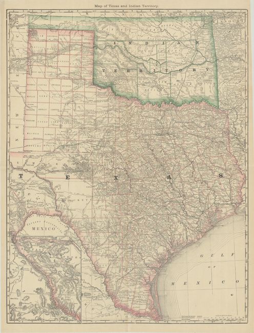
A. Map of Texas and Indian Territory, by Hiram H. Hardesty, circa 1883 (19.3 x 24.9"). A very detailed map of Texas and Indian Territory with an inset map of west Texas on the same scale. Shows good detail of roads, completed railroads, and projected railroads. Tom Green County is shown in a large, early configuration, not yet divided into Sterling, Irion, Coke, and Midland. In Greer County in southwestern Indian Territory two boundaries are shown: “Boundary Claimed by the State of Texas,” and “Boundary Claimed by the United States.” The dispute was ultimately decided by the Supreme Court which accepted the United States boundary and Greer County became part of the Indian Territory. From the 1883 edition of Hardesty’s atlas, before the Texas map was reduced in size. Condition: Issued folding on a clean sheet with one tiny spot in the bottom right corner of the image.
B. Tunison's Texas and Indian Territory, by H.C. Tunison, circa 1890 (13.0 x 19.6"). In Tunison's style, this is a finely lithographed map with original bright coloring. By this period most mapmakers had adopted printed color rather than the more labor intensive hand coloring employed here. It is decorated with a Victorian style border and title cartouche, which gives the population of Texas as 2,235,523 and no population reported for Indian Territory. At lower left is an inset "The Western Part of Texas on Reduced Scale." In present-day Oklahoma, the panhandle and western portion is shown as Oklahoma Territory, while the shrinking Indian Territory occupies the eastern half. Greer County, originally established in 1860, is shown as part of Texas. In 1896, it was abolished and awarded to Indian Territory by the U.S. Supreme Court. Tunison's maps were printed on both sides; on the verso are single-page maps of Nebraska and Alabama. Condition: A clean, bright example.
References:
Condition: A
See description above.