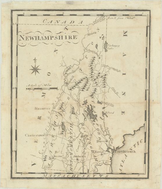
"[Lot of 2] The State of New Hampshire Compiled Chiefly from Actual Surveys [and] New Hampshire",
Subject: New Hampshire
Period: 1799 (circa)
Publication:
Color: Black & White
A. The State of New Hampshire Compiled Chiefly from Actual Surveys, by John Payne, from Payne's Geography, dated 1799 (7.3 x 11.8"). Finely engraved map showing the original five counties, towns, roads, and good detail of the watershed and topography. At the northern boundary is the Indian Carrying Place and 42,000 acres to Dartmouth College. Another charming feature is a note in the blank area at right stating, The White Hills appear many Leagues off at Sea like white Clouds just rising above the Horizon. Drawn By. A. Anderson and engraved by C. Tiebout. Condition: Issued folding with light toning and scattered foxing. There is a repaired tear in the upper left corner of the map and small remnants of framing tape along the edges of the sheet on recto. (B)
B. New Hampshire, by Joseph Scott, from The New and Universal Gazetteer, circa 1799 (6.2 x 7.5"). Five counties are shown by dotted lines, and there is good detail of towns, roads, watershed and topography. A note in the northernmost part of the state identifies 42,000 acres to Dartmouth College. This is the second state of this map. This edition is nearly identical to the first state, with only minor changes made in order to strengthen the impression. Condition: Light foxing with small remnants of framing tape along the edges of the sheet on recto. (B+)
References: Cobb (New Hampshire) #72 & #78; Wheat & Brun #186 & 190.
Condition:
See description above.