"[Lot of 2] Map No. 1 From San Francisco Bay to the Northern Boundary of California... [and] Map No. 2 From the Northern Boundary of California to the Columbia River...", Williamson & Abbot
Subject: California & Oregon
Period: 1855 (dated)
Publication: U.S. Pacific Railroad Surveys
Color: Black & White
Size:
23.1 x 27.3 inches
58.7 x 69.3 cm
During the 1850s, the U.S. government sponsored an extensive series of expeditions designed to gather information on the vast new territories that had been acquired in western North America. The discovery of gold in California further stimulated westward traffic and heightened the need for a faster and more convenient way to bring the far-flung parts of the country together. In 1853 Congress commissioned the Army's Topographic Bureau to conduct a series of surveys to find a suitable route for a transcontinental railroad. There were six major expeditions; five of them covered the area between the Great Plains and west coast, and the sixth explored the coastal states of California and Oregon. All of these expeditions were accompanied by naturalists and artists to document the landscape, flora and fauna along the route.
The reports, maps and lithographs were published in the 13 volume report "Explorations and Surveys to ascertain the most practicable and economical route for a Railroad from the Mississippi river to the Pacific Ocean."
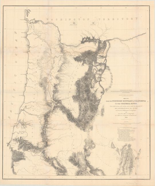
These two U.S. Pacific Railroad Survey maps by Lieuts. R.S. Williamson and H.L. Abbot cover California and Oregon:
The first map is quite detailed along the coast from San Francisco Bay to the northern border with Oregon with place names, watershed, and fine hachure in the mountainous areas. The balance of the map is mostly in skeletal format with an area to the west is noted as Unexplored Instrumentally. It locates the Emigrant Trail plus the earlier explorations of Warner and Williamson in 1849, and Wessell in 1852. The map notes the place where Warner was killed in 1849. Topography on the map was not added by this survey but taken from numerous sources including Fremont's Map of Oregon and Upper California.
The second map covers the region from the Siskoyou Range and Klamath Lakes north to above the Columbia River. It is finely engraved with much topographical and watershed detail including fine hachure throughout mountainous area. It also locates the Emigrant Road, unexplored regions, various routes of the surveying parties, the historical routes of Fremont and Warner, the first settlements, and much more.
References: Wheat (TMW) #881 & #882.
Condition: B+
Both maps were issued folding, now flattened with archival repairs to some short splits along the folds and a couple of minor edge tears. There are horizontal misfolds, minor toning and foxing, and light chalk residue. The left margin has been extended on the first map to accommodate framing.