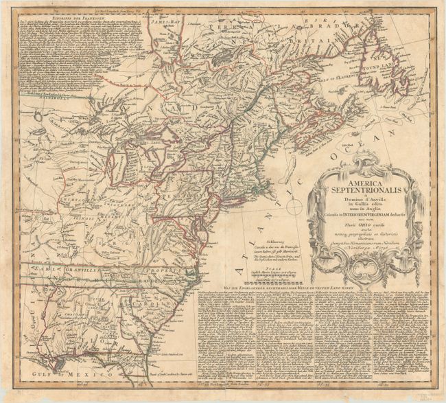
"America Septentrionalis a Domino d'Anville in Galliis Edita nunc in Anglia Coloniis in Interiorem Virginiam Deductis nec non Fluvii Ohio Cursu...", Homann Heirs
Subject: Colonial Eastern United States & Canada
Period: 1756 (dated)
Publication:
Color: Hand Color
Size:
20.1 x 18.1 inches
51.1 x 46 cm
This informative and interesting map of colonial North America from the French and Indian War period shows the area from James Bay and Newfoundland in the north to northern Florida and the Gulf Coast in the south. The map is based on D'Anville's cartography with Jefferys' map of 1755 for the political detail. It shows the British and French possessions from a British point of view. The western extent of the map is just west of the Mississippi River with Virginia, Earl Granvilles Property and North Carolina all extending off the map. The boundary of New York crosses Lakes Ontario, Huron and Erie to include the lower peninsula of Michigan. This map shows a very early Georgia, chartered in 1754. It is embellished with a large rococo cartouche. The extensive text in German, describing the British claims and French encroachments, was taken from Jefferys' map.
References: McCorkle #756.1; Sellers & Van Ee #68.
Condition: B+
Contemporary outline color on a lightly toned sheet with tiny, scattered wormholes and some chips and tears in the bottom margin. There is a centerfold separation that enters 4" into the image that has been closed on verso with old paper.