Rare Hand Colored Pictorial Map of the Maritimes, from the Estate of the Artist
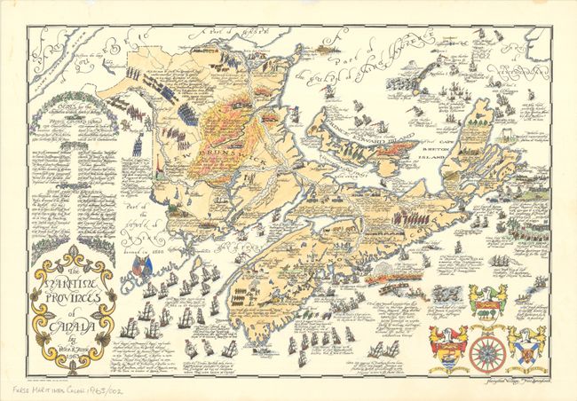
"The Maritime Provinces of Canada",
Subject: Eastern Canada
Period: 1963 (dated)
Publication:
Color: Printed Color
Size:
22 x 14.9 inches
55.9 x 37.8 cm
Peter R. Furse's rare map of New Brunswick, Nova Scotia, and Prince Edward and Cape Breton islands brings the history of the region to life in his elegant graphic style. This example is a rare instance of a hand-colored 20th-century pictorial map, here executed by Kathy Hooper, the artist's daughter. Illustrations cover the history of the provinces from circa 1000, when Eric the Red sailed the North Atlantic, to 1917, when a French ammunition ship wrecked in Halifax Harbour. Major battles, railroads, and discoveries dot the landscape. The center of New Brunswick is engulfed in the flames of the 1825 Miramichi fire. The waters are filled with sailing ships from different eras. At left is a listing of further historical events that could not fit on the map. An ornate title cartouche, fancy compass rose, and three coats of arms complete the composition. Completed by Furse in Hampton Village, New Brunswick, and printed by Lingley Printing Company Limited.
This map is from the estate of artist and cartographer Peter R. Furse (1901-70). Furse was born 1901 in Farnham, Surrey, England. During World War I, he enlisted in the Royal Navy. He worked as a cartographer and graduated from Emmanuel College, University of Cambridge, in 1922. He moved to Africa and was stationed in Cape Town, South Africa during World War II. It was during his time in Africa that Furse began to make pictorial maps. His family relocated to North America, eventually settling in New Brunswick, Canada in 1962. Once there, he became an active member of the "Hampton Group" artists' community and continued to work on his art until his death in 1970. Furse's terrific style mixes a 20th-century graphic sensibility with an uncommon elegance that hearkens back to the aesthetics of previous centuries of mapmaking.
For other maps by Peter Furse, see lots 97 and 102.
References: Rumsey #15278.
Condition: A
On watermarked Superfine Linen Record 100% Canadian Rag by Rolland Paper Co. There are a couple minor spots in the map image and a few faint stains confined to the blank margins.