"[Lot of 3 - Battle at Wounded Knee] Map of the Country Embraced in the Recent Campaign Against the Hostile Sioux Indians of Dakota... [and] Sketch of the Scene of the Mission Fight... [and] Scene of the Fight with Big Foots Band...", U.S. Army
Subject: South Dakota
Period: 1890-91 (dated)
Publication: H.R. Doc. 1, 52nd Congress, 1st Session
Color:
These three maps accompanied the congressional report on the movements of the U.S. military forces and the Indian band of Chief Big Foot that finally led to the tragic battle on December 29, 1890, ending the long history of the Indian Wars in the Dakotas. The maps are individually described below.
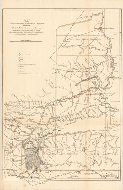
A. Map of the Country Embraced in the Recent Campaign Against the Hostile Sioux Indians of Dakota Showing the Different Positions of Troops from the Beginning to the Surrender in January, 1891, printed color (14.7 x 22.1"). This is a terrific map of considerable historical significance as it shows the location of the Battle of Wounded Knee, here labeled as 'Affair at Wounded Knee, Dec 29, 1890'. A misunderstanding between soldiers and Indians waiting to surrender at Wounded Knee, South Dakota, touched off a massacre of some 300 Sioux men, women and children. The campaign was an attempt to suppress the Ghost Dance movement. At the height of the tension, Sitting Bull was killed. The location of his camp is noted on the map. In exceptional detail, scores of wagon roads and trails are laid out, many named, numerous military positions with red, yellow and blue overprinted icons are keyed to legend. The icons locate the first, second, third and fourth position of the troops, along with the same number of positions of Hostile Indians. The map locates numerous forts and all Indian reservations in the region including Lower Brule, Pine Ridge, Rosebud and Standing Rock. A surprising number of settlements including Valentine, Clinton, Hay Springs, Wayside, Moulton, Rapid City, Cheyenne City, the Standing Rock Agency and more are named. Prepared by the Eng'r Off. Hdqrs Dept. of Missouri. Condition: There are a few tiny edge tears that just pass the neatline that have been closed on verso with archival tissue.
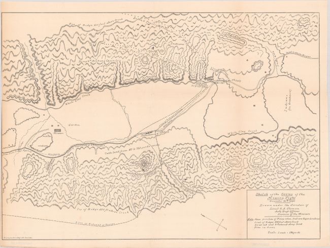
B. Sketch of the Scene of the Mission Fight December 30th 1890, black & white (17.0 x 12.1"). This uncolored map was drawn under the Direction of Lieut. S.A. Cloman, Act'g Eng'r Officer Division of the Missouri. This highly detailed map is drawn on a scale of 1 inch = 150 yards. The various positions of the 7th and 9th Calvary are shown. The Indian warrior positions and their lines of retreat are also noted. It locates the wagon roads from Pine Ridge Agency and to White River; names White Clay Creek, the (Drexel) Mission and garden, and shows the topography in great detail. Condition: Trimmed to the neatline at left with a 2" fold separation at top that has been closed on verso with archival tissue.
C. Scene of the Fight with Big Foots Band, Dec. 29th 1890, Showing Position of Troops When First Shot Was Fired, black & white (8.4 x 7.5"). Also drawn at a scale of 1 inch = 150 yards, the map is highly detailed. It indicates the positions of mounted and unmounted troops, the Cavalry Camp, G Troop, Indian Scouts, and more; names Wounded Knee Creek, Wounded Knee Road, the Porcupine x Medicine Root Road, and the cutoff to W.K. Road. Drawn by Pvt. James Hade. Condition: There is a 2.5" split along the left border at top that has been closed on verso with archival tissue.
References:
Condition: B+
All issued folding with faint toning along the folds. See description above for additional details.