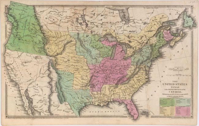
"The United States Texas & the British Provinces of the Canadas, Newfoundland, Nova Scotia, N. Brunswick & Prince Edward Island", Huntington, F. J.
Subject: United States & Canada, Texas
Period: 1838 (dated)
Publication:
Color: Hand Color
Size:
18.3 x 11 inches
46.5 x 27.9 cm
This rarely seen map features an Independent Republic of Texas with the long stove-pipe border extending into the Rocky Mountains above Longs Peak. The huge Oregon Territory is a great example of the disagreement over this portion of the U.S./Canadian boundary between the United States and Great Britain commonly knows as Fifty-Four Forty or Fight dispute. Mexico controls California and the Southwest as the map pre-dates the Mexican War by nearly a decade. There are only two large territories in the Midwest. Missouri Territory stretches from Texas to the boundary with Canada. It is bounded on the west by Oregon and includes in its southern part the oversized Indian Territory. On its eastern border the unnamed Dakota Territory fills in the area between Canada, Missouri and Wisconsin. Four tables below the title list each state and territory with the area given for each in square miles.
References:
Condition: B+
A good example with attractive color and light offsetting.