"Johnson's New Illustrated (Steel Plate) Family Atlas…", Johnson & Browning
Subject: Atlases
Period: 1861 (dated)
Publication:
Color: Hand Color
Size:
15.5 x 18.5 inches
39.4 x 47 cm
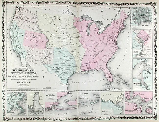
This very handsome and complete large folio atlas is the most desirable 1861 edition. It includes the beautifully engraved "American Atlas" frontispiece with original tissue guard and 58 maps, three of which are neither numbered nor listed in the Table of Contents; The New Military Map which shows the U.S. divided into seven military departments, Georgetown and the City of Washington, and Russia showing the eastern border not yet past Khirgiz Country and Siberia. The Nebraska, Dakota, Colorado & Kansas map shows Nebraska with a long panhandle. Washington and Oregon shows Washington in the inverted "L" shape as it wraps around Oregon to Utah. The California and Territories of New Mexico and Utah map is the uncommon issue with the newly formed Nevada shown occupying part of California to the summit line of the Sierras. The Confederate Territory of Arizona is named in the southern portion of New Mexico Territory on this map. Hardbound in green cloth with leather spine and corners, embossed and gilt on spine and titling on cover. Marbled endpapers, engraved frontispiece, title page, List of Maps, text and maps. This atlas has the finest condition contents we're ever seen in a Johnson atlas.
References:
Condition: A
Contents are very good to fine. The covers just slightly rubbed and bumped, but with spine mostly gone and both covers detached. Contents, including marbled free end papers are all present and tight. This will be a beautiful example of this atlas with the attention of a book binder.