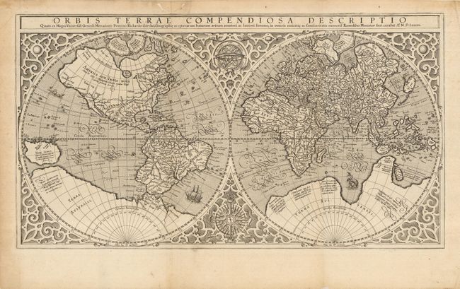
"Orbis Terrae Compendiosa Descriptio…", Mercator, Rumold
Subject: World
Period: 1587 (circa)
Publication:
Color: Black & White
Size:
20.5 x 11.3 inches
52.1 x 28.7 cm
An elegantly engraved strapwork border surrounds this double hemisphere map An armillary sphere and an elaborate compass rose are tucked between the hemispheres. Rumold based the map on his father Gerard's famous 21-sheet world map of 1569. The North Pole is depicted as a landmass surrounding a sea from which four rivers radiate and there is a well depicted Northwest Passage. A very early portrayal of the Great Lakes is represented by the large Mare Dulce , along with a trio of tiny lakes attached to a north-south tributary of the St. Lawrence River. This information was gleaned from the reports of Cartier's explorations. In the Antarctic is the imaginary southern continent showing the rich regions of Beach, Maletur and Lucach noted from the travels of Marco Polo. Japan is shown in its kite-shaped form taken from Ortelius. South America is shown with a bulge to the southwestern coast, and Tierra del Fuego is shown as part of the large Terra Australis. The map embodies information from many ancient authorities and is a wonderful view of classical cartography. This is an early impression done prior to 1603, as it lacks the plate cracks in the title that show up after that period.
References: Shirley #157.
Condition: A
Nice impression. Some worming and minor repairs in margins.