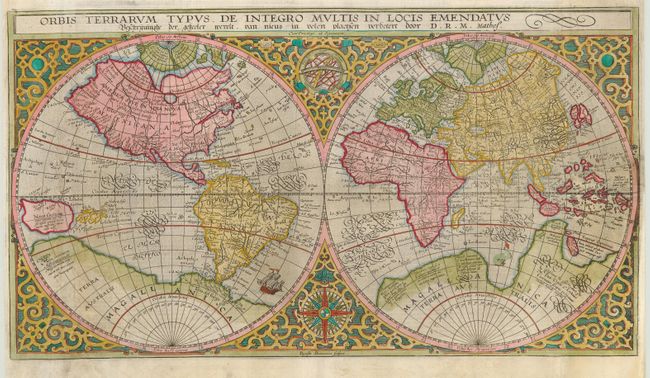
"Orbis Terrarum Typus de Integro Multis in Locis Emendatus", Plancius, Petrus
Subject: World
Period: 1620 (circa)
Publication:
Color: Hand Color
Size:
20.3 x 11.3 inches
51.6 x 28.7 cm
This handsome world map, first issued in 1590, was based on Rumold Mercator's map of 1587. It incorporates the improvements made by Ortelius with a re-shaped South America and the inclusion of the Solomon Islands. On this map Plancius introduced new information, based on Portuguese reports, on the far-west coast of America and the western coastline of Africa. Japan is shown for the first time as one small and three larger islands. This example is state 3 from a Dutch Bible with the attribution D.R.M. Mathes. It was beautifully engraved by Baptista Doetecum and set in a strapwork surround with a compass rose and armillary sphere tucked between the hemispheres.
References: Shirley #177
Condition: B
Expert repairs along outside folds with slight loss and facsimile, and some paper replacement (leaf-casting method) in side margins. These repairs were skillfully executed and are only visible on very close inspection.