"A Gazetteer of Texas (Second Edition) by Henry Gannett", U.S. Gov't Printing Office
Subject: Texas
Period: 1904 (published)
Publication: HR Doc 676, 58th Cong., 2nd Sess.
Color: Black & White
Size:
35.5 x 30.8 inches
90.2 x 78.2 cm
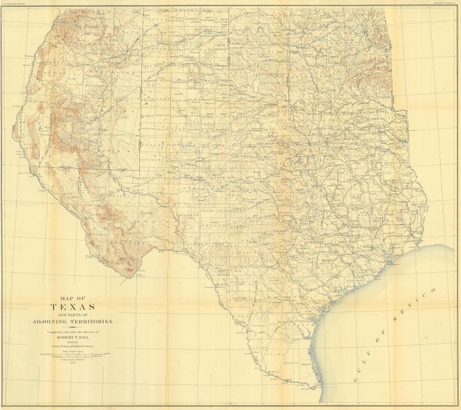
Book contains a large and extremely detailed map of the state that also includes most of Oklahoma and New Mexico east of the Rio Grande and south of Taos. It details counties, county seats, railroads, topography and watershed, and much more. This map by Robert T. Hill, a widely known scholar, teacher and geologist, brought new sophistication to Texas cartography and helped set new scientific standards for the region's cartography. The map folds into a pocket at the rear of this second edition of Gannett's work. Several maps in text relate to mean annual temperature and rainfall, population density in 1850, 1860, 1870, 1890 and 1900, existing railroads, etc. A brief text by Henry Gannett also covers the state's area, climate, exploration and settlement, population, industries, land and surveys and railroads. Gannett was the Chief Geographer of the United States Geological Survey under John Wesley Powell and the Chairman of the United States Board of Geographic Names. As a President of the National Geographic Society, Gannet is credited with raising the quality of maps at the U.S.G.S. to their high perfection and was called the "Father of American Map-Making."
References:
Condition: A
Rebound in modern green cloth with black quarter leather and gilt spine. Contents and map very good to fine, with split inside at one signature.