Showing Featured Lots(remove filter)
Showing results for:Auction 194
Catalog Archive
50 lots
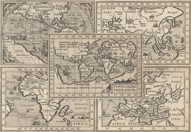
Auction 194, Lot 2
Subject: World & Continents
Ortelius/Coignet
[Lot of 5] Typus Orbis Terrarum [and] America [and] Asia [and] Africa [and] Europa, 1601
Size: 4.8 x 3.3 inches (12.2 x 8.4 cm)
Estimate: $1,500 - $1,800
Matching Set from Miniature Ortelius Atlas
Sold for: $1,100
Closed on 9/13/2023
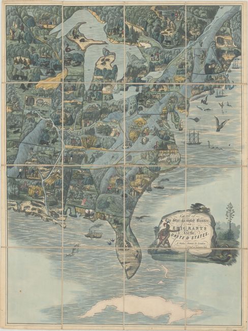
Auction 194, Lot 46
Subject: Cartographic Miscellany, Games, Eastern United States
Wallis, Edward
Game of the Star-Spangled Banner, or Emigrants to the United States, 1840
Size: 19.5 x 26.4 inches (49.5 x 67.1 cm)
Estimate: $5,500 - $7,000
One of the Earliest Game Maps of the United States
Sold for: $5,500
Closed on 9/13/2023
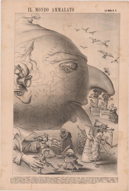
Auction 194, Lot 48
Subject: Cartographic Miscellany, Europe
Il Mondo Ammalato, 1879
Size: 13.4 x 20.8 inches (34 x 52.8 cm)
Estimate: $750 - $1,000
Rare Satirical Broadside on the Ottoman Empire's Problems after the Russo-Turkish War
Sold for: $850
Closed on 9/13/2023
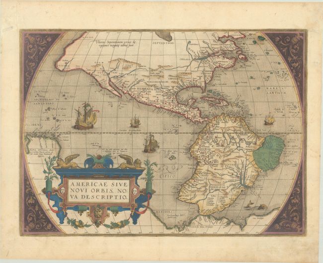
Auction 194, Lot 55
Subject: Western Hemisphere - America
Ortelius, Abraham
Americae sive Novi Orbis, Nova Descriptio, 1579
Size: 19.6 x 14.2 inches (49.8 x 36.1 cm)
Estimate: $5,500 - $6,500
Ortelius' Influential Map of the New World - Second Plate in Contemporary Color
Sold for: $6,000
Closed on 9/13/2023
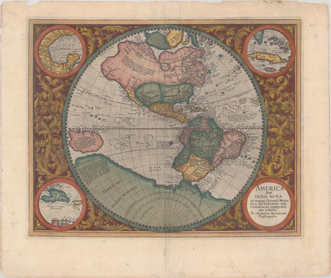
Auction 194, Lot 56
Subject: Western Hemisphere - America
Mercator, Michael
America sive India Nova, ad Magnae Gerardi Mercatoris aui Universalis Imitationem in Compendium Redacta, 1607
Size: 18 x 14.4 inches (45.7 x 36.6 cm)
Estimate: $3,250 - $4,000
Mercator's Foundation Map for the Americas
Sold for: $2,400
Closed on 9/13/2023
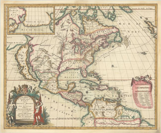
Auction 194, Lot 64
Subject: Colonial North America
Hennepin, Louis de (Fr.)
Amerique Septentrionalis Carte d'un Tres Grand Pays entre le Nouveau Mexique et la Mer Glaciale…, 1698
Size: 20.8 x 17.1 inches (52.8 x 43.4 cm)
Estimate: $3,500 - $4,250
Hennepin's Influential Map of North America with Contemporary Color
Sold for: $4,750
Closed on 9/13/2023
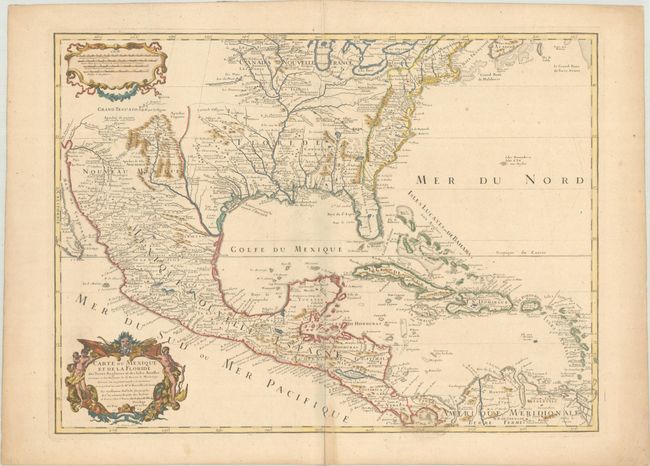
Auction 194, Lot 85
Subject: Colonial Eastern North America & West Indies
Delisle, Guillaume
Carte du Mexique et de la Floride des Terres Angloises et des Isles Antilles du Cours et des Environs de la Riviere de Mississipi..., 1703
Size: 25.6 x 18.8 inches (65 x 47.8 cm)
Estimate: $1,800 - $2,100
Landmark in American Cartography - First Printed Map to Accurately Depict the Mouth of the Mississippi River
Sold for: $1,600
Closed on 9/13/2023
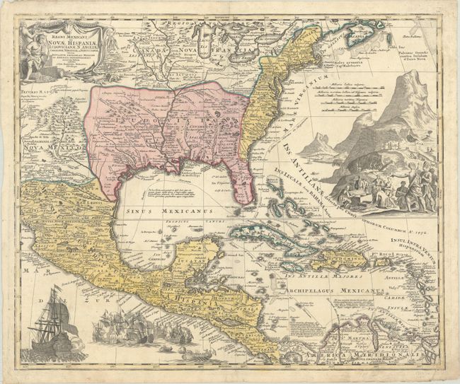
Auction 194, Lot 86
Subject: Colonial Eastern North America & West Indies
Homann, Johann Baptist
Regni Mexicani seu Novae Hispaniae, Ludovicianae, N. Angliae, Carolinae, Virginiae et Pensylvaniae nec non Insularum Archipelagi Mexicani in America Septentrionali Accurata Tabula, 1720
Size: 22.6 x 18.8 inches (57.4 x 47.8 cm)
Estimate: $1,600 - $1,900
Homann's Decorative Map of Colonial America in the Era of the War of the Spanish Succession
Sold for: $1,200
Closed on 9/13/2023
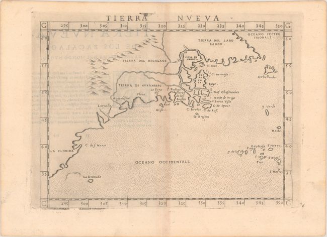
Auction 194, Lot 108
Subject: Eastern United States & Canada
Ruscelli, Girolamo
Tierra Nueva, 1574
Size: 9.8 x 7.1 inches (24.9 x 18 cm)
Estimate: $1,200 - $1,500
Ruscelli's Map of the East Coast
Sold for: $750
Closed on 9/13/2023
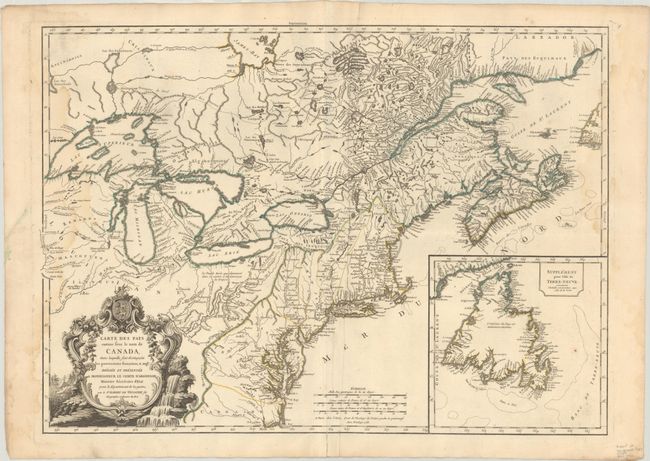
Auction 194, Lot 109
Subject: Colonial Northeastern United States & Canada
Robert de Vaugondy, Didier
Carte des Pays Connus sous le Nom de Canada, dans Laquelle sont Distinguees les Possessions Francoises, & Angl?..., 1755
Size: 26.4 x 18.9 inches (67.1 x 48 cm)
Estimate: $2,000 - $2,400
A Separately Issued, French Political Propaganda Map at the Outset of the French & Indian War
Sold for: $1,500
Closed on 9/13/2023
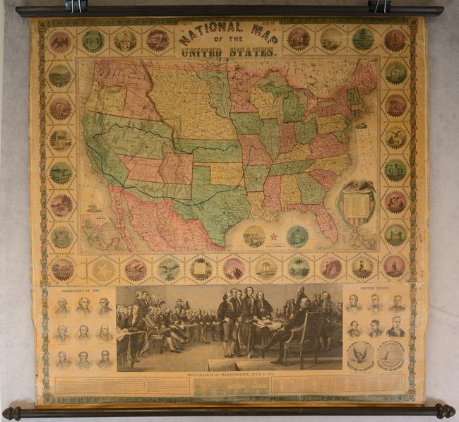
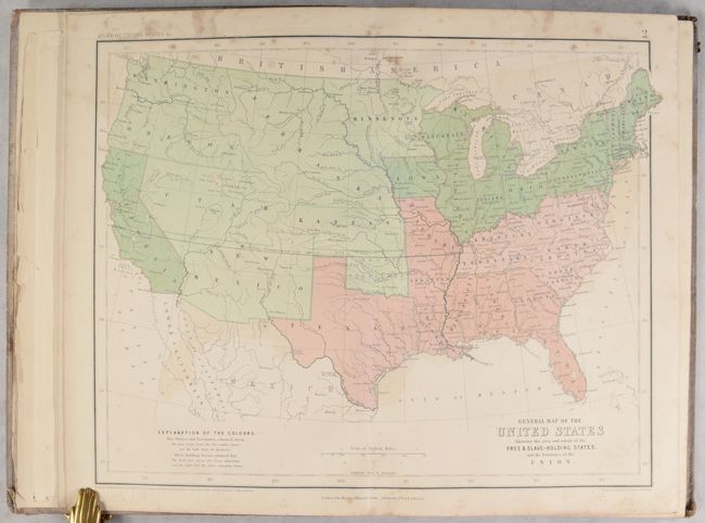
Auction 194, Lot 124
Subject: United States
Phelps & Watson
Phelps' New National Map of the United States, 1859
Size: 35.8 x 38 inches (90.9 x 96.5 cm)
Estimate: $2,400 - $3,000
Attractive Wall Map Issued at the Onset of the Civil War
Sold for: $1,800
Closed on 9/13/2023
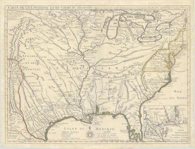
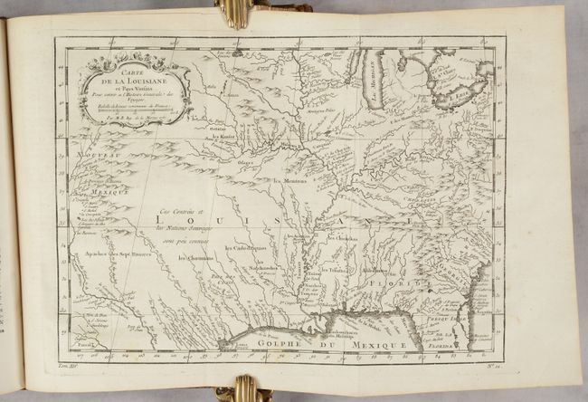
Auction 194, Lot 142
Subject: Colonial Eastern United States
Delisle, Guillaume
Carte de la Louisiane et du Cours du Mississipi Dressee sur un Grand Nombre de Memoires Entr'autres sur ceux de Mr. le Maire, 1718
Size: 25.6 x 19.2 inches (65 x 48.8 cm)
Estimate: $6,000 - $7,500
A Foundation Map for the Mississippi Valley and the First Appearance of Texas on a Printed Map - First Issue
Sold for: $8,000
Closed on 9/13/2023
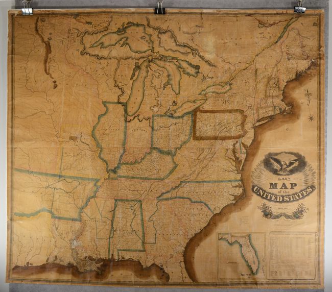
Auction 194, Lot 149
Subject: Eastern United States, Texas
Lay, Amos
Lay's Map of the United States. Compiled From the Latest and Best Authorities and Actual Surveys, 1827
Size: 60 x 51 inches (152.4 x 129.5 cm)
Estimate: $2,750 - $3,500
First Edition of Lay's Mammoth Map of the Young United States - Early Naming of Austin's Settlement
Sold for: $2,400
Closed on 9/13/2023

Auction 194, Lot 155
Subject: Colonial New England & Mid-Atlantic United States
Blaeu, Willem
Nova Belgica et Anglia Nova, 1641
Size: 19.9 x 15.2 inches (50.5 x 38.6 cm)
Estimate: $2,000 - $2,300
Important Map of Colonial New England and the Mid-Atlantic
Sold for: $1,500
Closed on 9/13/2023
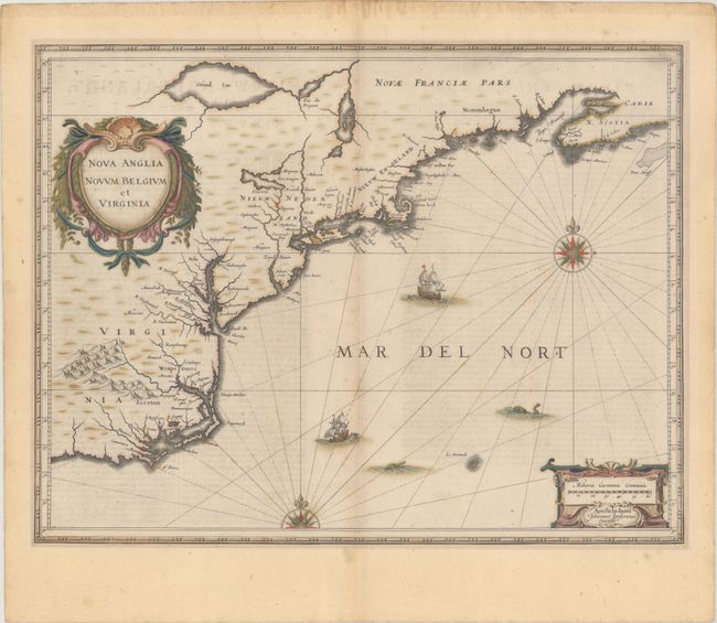
Auction 194, Lot 156
Subject: Colonial New England & Mid-Atlantic United States
Jansson, Jan
Nova Anglia Novum Belgium et Virginia, 1645
Size: 19.9 x 15.3 inches (50.5 x 38.9 cm)
Estimate: $1,200 - $1,500
Jansson's Influential Map of the East Coast
Sold for: $900
Closed on 9/13/2023

Auction 194, Lot 161
Subject: Colonial New England & Mid-Atlantic United States, Revolutionary War
Brion de la Tour, Louis
Carte du Theatre de la Guerre Entre les Anglais et les Americains: Dressee d'Apres les Cartes Anglaises les Plus Modernes, 1778
Size: 20.4 x 29.9 inches (51.8 x 75.9 cm)
Estimate: $3,000 - $3,750
Important Map Depicting Tipping Point of Revolutionary War
Unsold
Closed on 9/13/2023

Auction 194, Lot 167
Subject: Colonial Mid-Atlantic United States
Browne/Senex
A New Map of Virginia Mary-Land and the Improved Parts of Pennsylvania & New Jersey..., 1719
Size: 21.8 x 19.1 inches (55.4 x 48.5 cm)
Estimate: $3,250 - $4,000
Map of Chesapeake Bay Based on Landmark Herrman Map
Unsold
Closed on 9/13/2023

Auction 194, Lot 277
Subject: Lake Champlain, Colonial New York, Revolutionary War
Faden, William
The Attack and Defeat of the American Fleet Under Benedict Arnold, by the Kings Fleet Commanded by Sir Guy Carleton, Upon Lake Champlain, the 11th of October, 1776, 1776
Size: 16.4 x 10.4 inches (41.7 x 26.4 cm)
Estimate: $6,000 - $7,500
One of the Rarest Revolutionary Battle Plans
Sold for: $6,000
Closed on 9/13/2023

Auction 194, Lot 293
Subject: Pennsylvania
Barnes, R. L.
Map of Pennsylvania, Constructed from the County Surveys Authorized by the State; and Other Original Documents, Revised and Improved..., 1850
Size: 74.6 x 50.4 inches (189.5 x 128 cm)
Estimate: $3,000 - $3,750
Melish's Epic Map of the State - Updated by William Morris
Unsold
Closed on 9/13/2023

Auction 194, Lot 295
Subject: Gettysburg, Pennsylvania, Civil War
Bachelder, John B.
Gettysburg. Repulse of Longstreet's Assault, 1876
Size: 35 x 14.4 inches (88.9 x 36.6 cm)
Estimate: $1,600 - $1,900
Stunning View of Pickett's Charge
Unsold
Closed on 9/13/2023
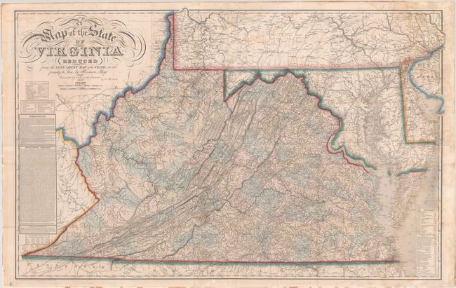
Auction 194, Lot 305
Subject: Virginia & West Virginia
Bucholtz, Ludwig von
A Map of the State of Virginia Reduced from the Nine Sheet Map of the State, in Conformity to Law: by Herman Boye, 1859
Size: 47.5 x 29.8 inches (120.7 x 75.7 cm)
Estimate: $14,000 - $17,000
Bucholtz Edition of Herman Boye's Four-Sheet Map of Virginia
Unsold
Closed on 9/13/2023
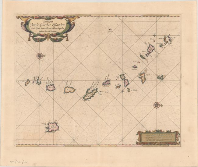
Auction 194, Lot 336
Subject: Lesser Antilles
Roggeveen, Arent
Pascaerte vande Caribes Eylanden, van 't Eylant Granadillos, tot 't Eylant Anguilla, 1675
Size: 20.1 x 16.2 inches (51.1 x 41.1 cm)
Estimate: $3,000 - $3,750
Rare First Edition of Dutch Sea Chart in Full Contemporary Color
Sold for: $2,200
Closed on 9/13/2023
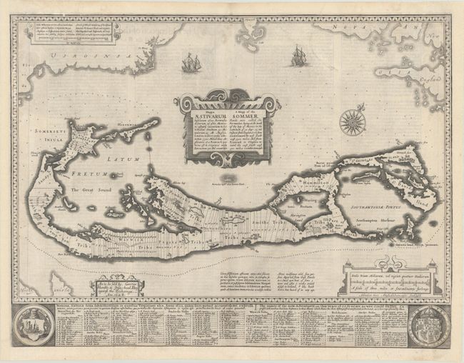
Auction 194, Lot 370
Subject: Bermuda
Speed, John
Mappa Aestivarum Insularum Alias Bermudas Dictarum... / A Mapp of the Sommer Islands Once Called the Bermudas..., 1626
Size: 20.8 x 15.8 inches (52.8 x 40.1 cm)
Estimate: $1,600 - $1,900
Speed's Foundation Map of Bermuda
Unsold
Closed on 9/13/2023
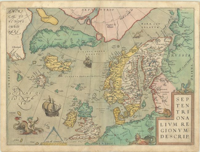
Auction 194, Lot 378
Subject: Arctic & Northern Europe
Ortelius, Abraham
Septentrionalium Regionum Descrip., 1572
Size: 19.4 x 14.3 inches (49.3 x 36.3 cm)
Estimate: $2,300 - $2,750
Early Example of Ortelius' Map of the Arctic with Mythical Islands in Contemporary Color
Sold for: $2,300
Closed on 9/13/2023
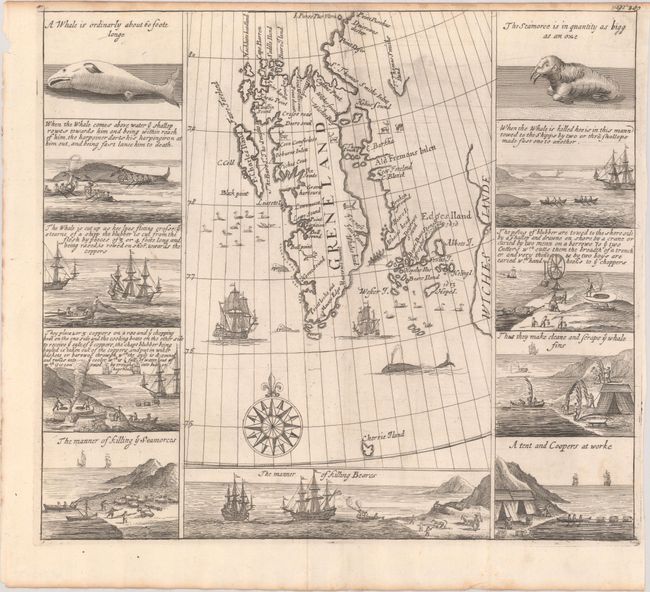
Auction 194, Lot 380
Subject: Spitsbergen
Purchas, Samuel
[Greneland], 1704
Size: 12.8 x 11.4 inches (32.5 x 29 cm)
Estimate: $950 - $1,200
Important Whaling Map of Spitsbergen
Sold for: $650
Closed on 9/13/2023
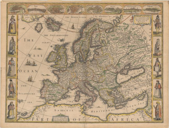
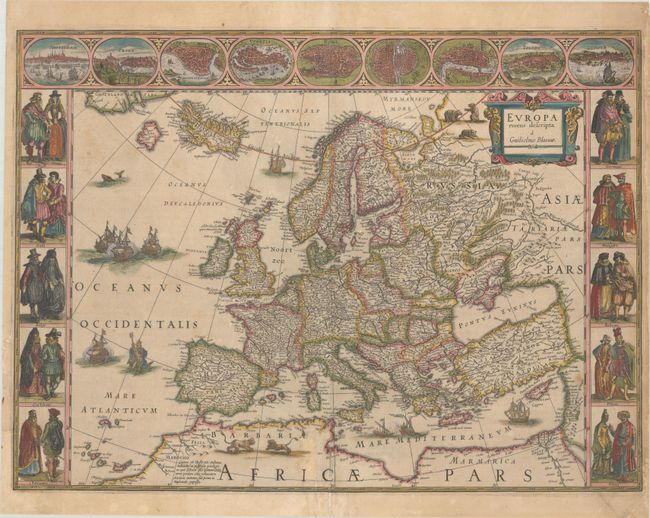
Auction 194, Lot 382
Subject: Europe
Speed, John
Europ, and the Cheife Cities Contayned Therin, Described; with the Habits of Most Kingdoms Now in Use, 1626
Size: 20.2 x 15.4 inches (51.3 x 39.1 cm)
Estimate: $2,750 - $3,500
Speed's Carte-a-Figures Map of Modern Europe
Sold for: $2,000
Closed on 9/13/2023
Auction 194, Lot 383
Subject: Europe
Blaeu, Willem
Europa Recens Descripta, 1635
Size: 22.1 x 16.3 inches (56.1 x 41.4 cm)
Estimate: $2,400 - $3,000
Blaeu's Carte-a-Figures Map of Europe
Sold for: $1,800
Closed on 9/13/2023
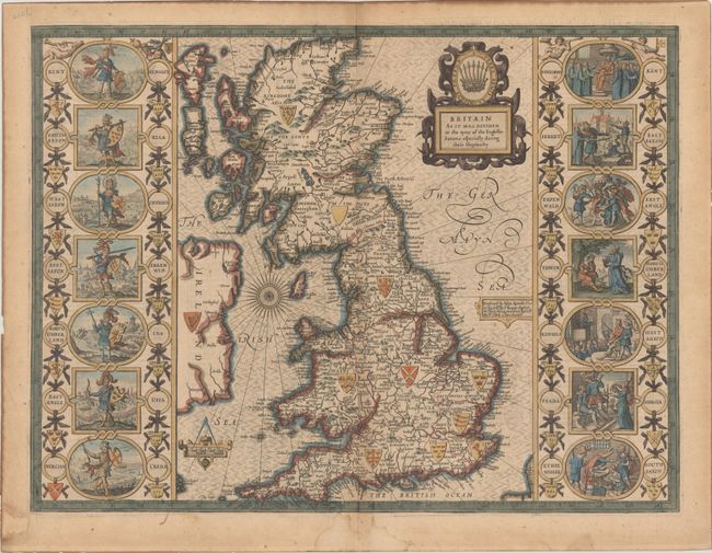
Auction 194, Lot 393
Subject: Britain
Speed, John
Britain as It Was Devided in the Tyme of the Englishe-Saxons Especially During Their Heptarchy, 1676
Size: 20.1 x 15.1 inches (51.1 x 38.4 cm)
Estimate: $2,400 - $3,000
Speed's "Heptarchy" Map Depicting the Saxon Kingdoms
Unsold
Closed on 9/13/2023
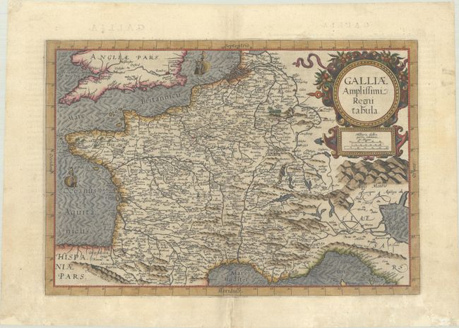
Auction 194, Lot 458
Subject: France
Jode, Cornelis de
Galliae Amplissimi Regni Tabula, 1593
Size: 17.8 x 12.1 inches (45.2 x 30.7 cm)
Estimate: $1,000 - $1,300
Rare Map of France
Unsold
Closed on 9/13/2023
Auction 194, Lot 462
Subject: France, Atlases
Brion de la Tour/Desnos
Coup d'Oeil General sur la France..., 1765
Size: 8.4 x 10.9 inches (21.3 x 27.7 cm)
Estimate: $1,000 - $1,300
Early Thematic Atlas
Unsold
Closed on 9/13/2023
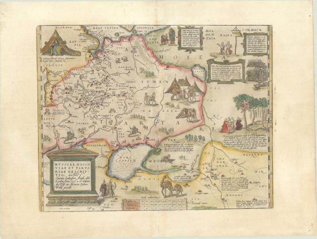
Auction 194, Lot 532
Subject: Russia, Eastern Europe & Central Asia
Ortelius, Abraham
Russiae, Moscoviae et Tartariae Descriptio. Auctore Antonio Ienkensono Anglo..., 1587
Size: 17.6 x 13.8 inches (44.7 x 35.1 cm)
Estimate: $1,500 - $1,800
Ortelius' Map of Russia with a Vignette of Ivan the Terrible
Sold for: $1,100
Closed on 9/13/2023
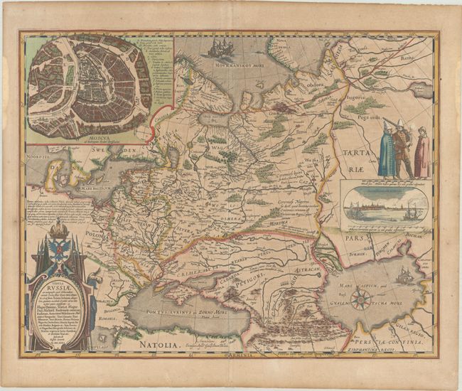
Auction 194, Lot 533
Subject: Russia in Europe
Blaeu, Willem
Tabula Russiae ex Autographo, quod Delineandum Curavit Foedor Filius Tzaris Boris Desumta ... M.DC.XIIII, 1635
Size: 21.4 x 16.8 inches (54.4 x 42.7 cm)
Estimate: $1,500 - $1,800
Blaeu's Decorative Map of Russia
Sold for: $1,100
Closed on 9/13/2023
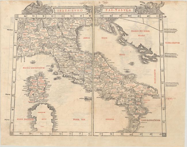
Auction 194, Lot 550
Subject: Italy, Sardinia & Western Balkans
Sylvanus, Bernard
Sexta Europae Tabula [on verso] Septima Europae Tabula, 1511
Size: 21.5 x 16.6 inches (54.6 x 42.2 cm)
Estimate: $4,000 - $5,000
Rare, Early Map of Italy Printed in Two Colors
Sold for: $3,000
Closed on 9/13/2023
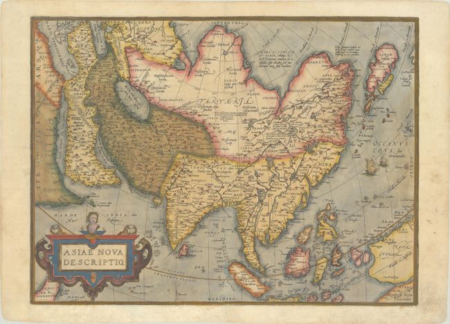
Auction 194, Lot 601
Subject: Asia
Ortelius, Abraham
Asiae Nova Descriptio, 1573
Size: 19.7 x 14.7 inches (50 x 37.3 cm)
Estimate: $1,200 - $1,500
Rare First Plate of Ortelius' Important Map of Asia in Contemporary Color
Sold for: $900
Closed on 9/13/2023
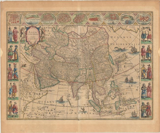
Auction 194, Lot 604
Subject: Asia
Blaeu, Willem
Asia Noviter Delineata, 1663
Size: 21.8 x 16.2 inches (55.4 x 41.1 cm)
Estimate: $2,750 - $3,500
Magnificent Carte-a-Figures Map of Asia in Full Contemporary Color
Sold for: $2,000
Closed on 9/13/2023
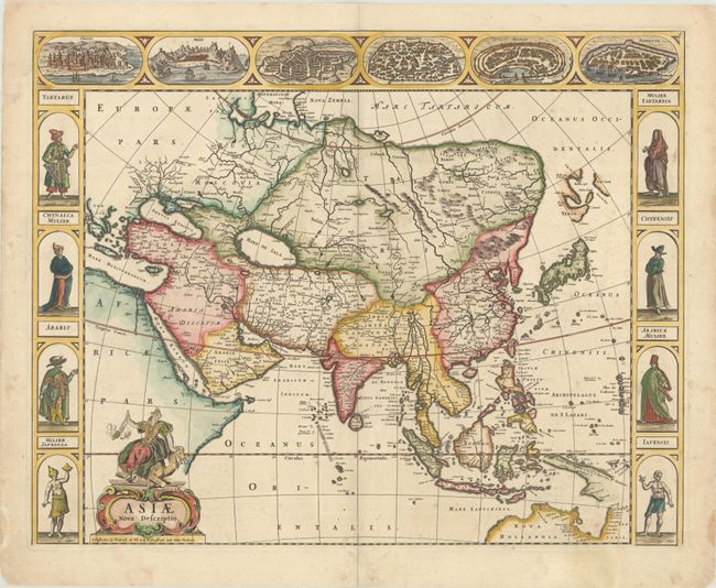
Auction 194, Lot 605
Subject: Asia
Wit, Frederick de
Asiae Nova Descriptio, 1670
Size: 21.9 x 17.4 inches (55.6 x 44.2 cm)
Estimate: $2,400 - $3,000
De Wit's Carte-a-Figures Map of Asia
Unsold
Closed on 9/13/2023
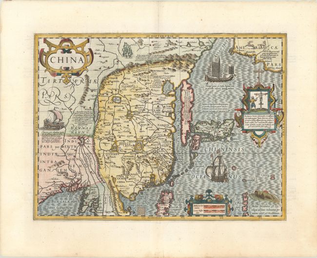
Auction 194, Lot 617
Subject: China, Korea & Japan
Mercator/Hondius
China, 1619
Size: 18.3 x 13.5 inches (46.5 x 34.3 cm)
Estimate: $2,400 - $3,000
Hondius' Map of China, Korea, and Japan
Sold for: $1,800
Closed on 9/13/2023
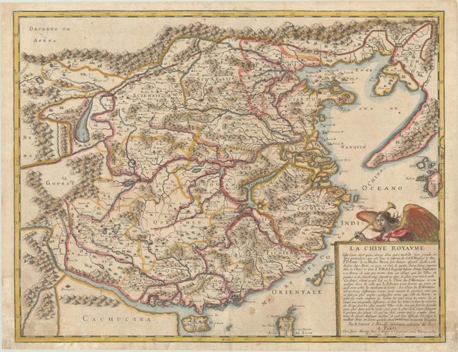
Auction 194, Lot 622
Subject: China & Korea
Sanson/Mariette
La Chine Royaume..., 1656
Size: 21.1 x 16.3 inches (53.6 x 41.4 cm)
Estimate: $1,200 - $1,500
Important Jesuit Map of China
Unsold
Closed on 9/13/2023
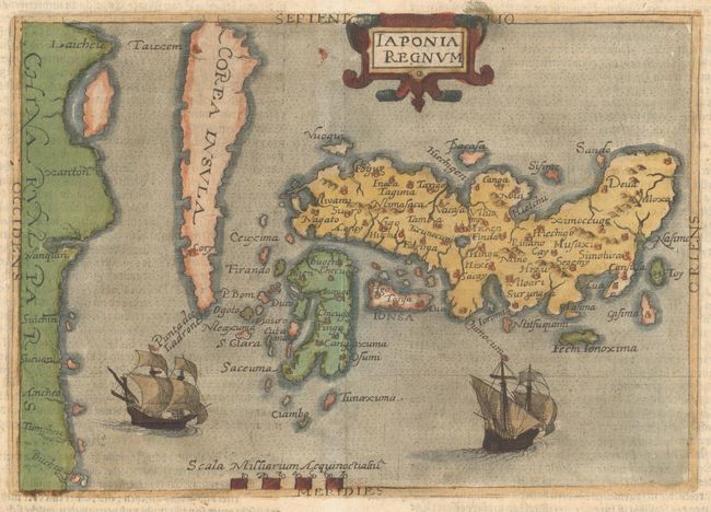
Auction 194, Lot 623
Subject: Japan & Korea
Botero, Giovanni
Iaponia Regnum, 1596
Size: 8.3 x 5.8 inches (21.1 x 14.7 cm)
Estimate: $3,000 - $3,750
Rare First Derivative of Ortelius/Teixeira Map of Japan
Unsold
Closed on 9/13/2023
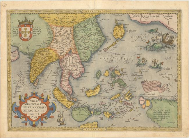
Auction 194, Lot 646
Subject: Southern & Southeast Asia
Ortelius, Abraham
Indiae Orientalis, Insularumque Adiacientium Typus, 1570
Size: 19.6 x 13.8 inches (49.8 x 35.1 cm)
Estimate: $2,750 - $3,500
Ortelius' Important Map of Southeast Asia in Full Contemporary Color - First Edition
Sold for: $2,000
Closed on 9/13/2023
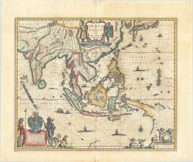
Auction 194, Lot 647
Subject: Southern & Southeast Asia
Blaeu, Willem
India quae Orientalis Dicitur, et Insulae Adiacentes, 1640
Size: 19.8 x 16.3 inches (50.3 x 41.4 cm)
Estimate: $1,600 - $1,900
The First Popular Map to Show European Discoveries in Australia
Unsold
Closed on 9/13/2023
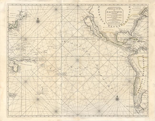
Auction 194, Lot 683
Subject: Pacific Ocean
Covens & Mortier
Mer de Sud, ou Pacifique, Contenant l'Isle de Californe, les Costes de Mexique, du Perou, Chili, et le Destroit de Magellanique &c..., 1721
Size: 29.3 x 23.5 inches (74.4 x 59.7 cm)
Estimate: $2,000 - $2,400
Dramatic Sea Chart Featuring the Island of California
Unsold
Closed on 9/13/2023

Auction 194, Lot 695
Subject: Prints - Cowboys
Mora, Joseph Jacinto
Levi's Round-Up of Cowboy Lore, 1960
Size: 22.9 x 30.4 inches (58.2 x 77.2 cm)
Estimate: $550 - $700
Levi's First Edition of Jo Mora's Decorative Rodeo Poster
Sold for: $400
Closed on 9/13/2023
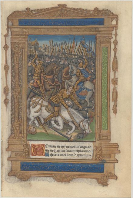
Auction 194, Lot 709
Subject: Early Printing
Hardouin, Gilles
[Book of Hours Leaf], 1510
Size: 5.9 x 8.8 inches (15 x 22.4 cm)
Estimate: $800 - $950
Penitential Psalms with Superb Image in Contemporary Hand Color with Gilt Highlights
Sold for: $850
Closed on 9/13/2023
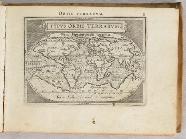
Auction 194, Lot 719
Subject: Atlases
Ortelius/Galle
[Epitome Theatri Orteliani], 1589
Size: 6.4 x 4.8 inches (16.3 x 12.2 cm)
Estimate: $5,500 - $7,000
Rare Miniature Atlas with 94 Maps Based on Ortelius
Sold for: $4,500
Closed on 9/13/2023
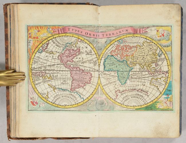
Auction 194, Lot 720
Subject: Atlases
Weigel, Christopher
Atlas Portatilis, oder Compendieuse Vorstellung der Ganzen Welt, in Einer Kleinen Cosmographie... , 1745
Size: 4.8 x 7.5 inches (12.2 x 19.1 cm)
Estimate: $2,000 - $2,400
Handsome Small Atlas in Full Contemporary Color
Sold for: $1,500
Closed on 9/13/2023
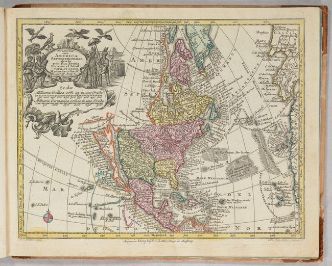
Auction 194, Lot 721
Subject: Atlases
Seutter/Lotter
[Atlas Minor Praecipua Orbis TerrarumImperia, Regna et Provincias, Germaniae Potissimum...], 1750
Size: 11.4 x 9.2 inches (29 x 23.4 cm)
Estimate: $1,900 - $2,200
Small Atlas with 20 Seutter/Lotter Maps Featuring Geographic Myths
Sold for: $1,400
Closed on 9/13/2023
Auction 194, Lot 730
Subject: Atlases
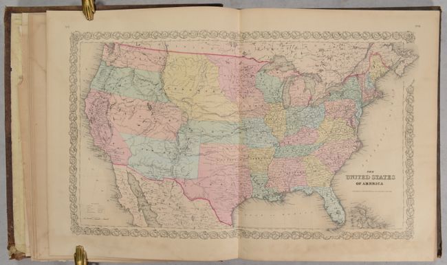
Colton, Joseph Hutchins
[Colton's Atlas of the World, Illustrating Physical and Political Geography ... Volume I. - North and South America, Etc.], 1856
Size: 16.8 x 19.1 inches (42.7 x 48.5 cm)
Estimate: $1,600 - $1,900
Features Many Desirable Maps of the Evolving American West
Sold for: $1,000
Closed on 9/13/2023
Auction 194, Lot 731
Subject: Atlases, North America
Rogers & Johnston
Atlas of the United States of North America, Canada, New Brunswick, Nova Scotia, Newfoundland, Mexico, Central America, Cuba, and Jamaica..., 1857
Size: 10.3 x 14.8 inches (26.2 x 37.6 cm)
Estimate: $2,750 - $3,500
Rare Rogers & Johnston Atlas with Desirable Maps of the American West
Sold for: $1,700
Closed on 9/13/2023
Auction 194, Lot 736
Subject: Exploration & Surveys
Prevost, Anton Francois
Histoire Generale des Voyages, ou Nouvelle Collection de Toutes les Relations de Voyages ... Tome Quatorzieme, 1757
Size: 8 x 10.5 inches (20.3 x 26.7 cm)
Estimate: $2,200 - $2,500
Prevost's Volume on the Americas
Sold for: $1,600
Closed on 9/13/2023
50 lots