Showing Featured Lots(remove filter)
Showing results for:Auction 188
Catalog Archive
58 lots
Page 1 of 2

Auction 188, Lot 1
Subject: World & Continents
Jansson, Jan
[Lot of 5] Typus Orbis Terrarum [with] Americae Descriptio [and] Africae Descriptio [and] Asia [and] Europae Nova Tabula, 1634
Size: 8 x 5.6 inches (20.3 x 14.2 cm)
Estimate: $2,400 - $3,000
Matching Set from Latin Edition of Atlas Minor
Unsold
Closed on 6/22/2022

Auction 188, Lot 4
Subject: World
Blaeu, Willem
Nova Totius Terrarum Orbis Geographica ac Hydrographica Tabula, 1640
Size: 21.6 x 16.2 inches (54.9 x 41.1 cm)
Estimate: $12,000 - $15,000
Blaeu's Magnificent Carte-a-Figures World Map with Rare Blank Verso
Unsold
Closed on 6/22/2022

Auction 188, Lot 5
Subject: World
Plancius, Petrus
Orbis Terrarum Typus de Integro Multis in Locis Emendatus..., 1643
Size: 20.3 x 11.3 inches (51.6 x 28.7 cm)
Estimate: $3,000 - $3,750
Plancius' World Map Surrounded by Elegant Strapwork
Sold for: $2,200
Closed on 6/22/2022

Auction 188, Lot 20
Subject: World
Sayer, Robert
A New Map of the World in Two Hemispheres with the New Discoveries & Tracts of the Two Circum Navigators..., 1760
Size: 37.9 x 21.6 inches (96.3 x 54.9 cm)
Estimate: $2,400 - $3,000
Gorgeous Double Hemisphere World Map
Sold for: $1,800
Closed on 6/22/2022
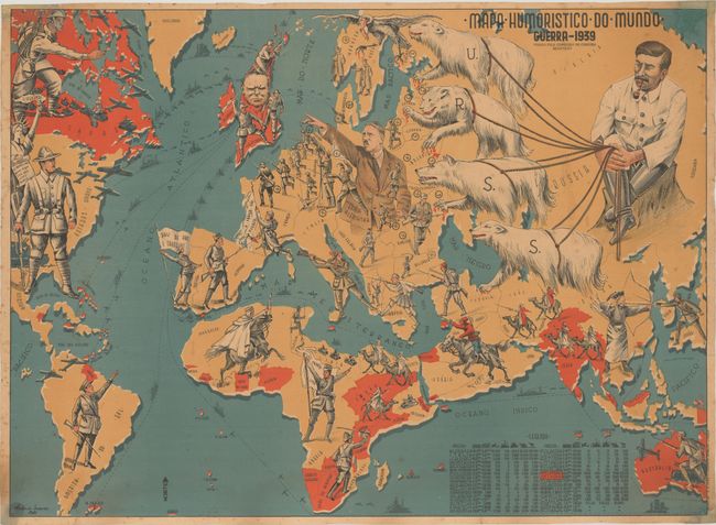
Auction 188, Lot 32
Subject: World, World War II
Mapa Humoristico do Mundo - Guerra - 1939, 1941
Size: 28.9 x 21.1 inches (73.4 x 53.6 cm)
Estimate: $2,400 - $3,000
Rare World War II Persuasive Map with Images of Hitler, Stalin and Churchill
Sold for: $7,500
Closed on 6/22/2022

Auction 188, Lot 50
Subject: Persuasive Maps, Russo-Japanese War
A Humorous Diplomatic Atlas of Europe and Asia, 1904
Size: 22.8 x 16.4 inches (57.9 x 41.7 cm)
Estimate: $2,750 - $3,500
Japanese Propaganda Map Depicting the Russian Octopus
Sold for: $2,000
Closed on 6/22/2022
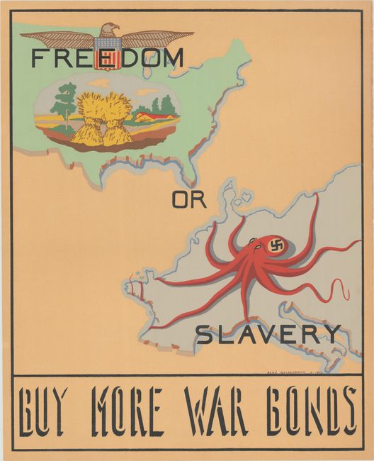
Auction 188, Lot 52
Subject: Cartographic Miscellany, World War II
Freedom or Slavery - Buy More War Bonds, 1943
Size: 14.7 x 18.4 inches (37.3 x 46.7 cm)
Estimate: $900 - $1,200
Rare WWII Propaganda Map Made by a Jewish Refugee and Former Prisoner-of-War
Sold for: $700
Closed on 6/22/2022
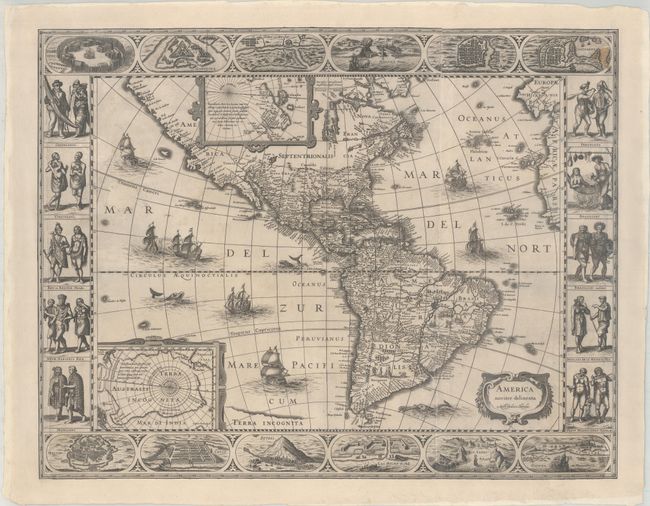
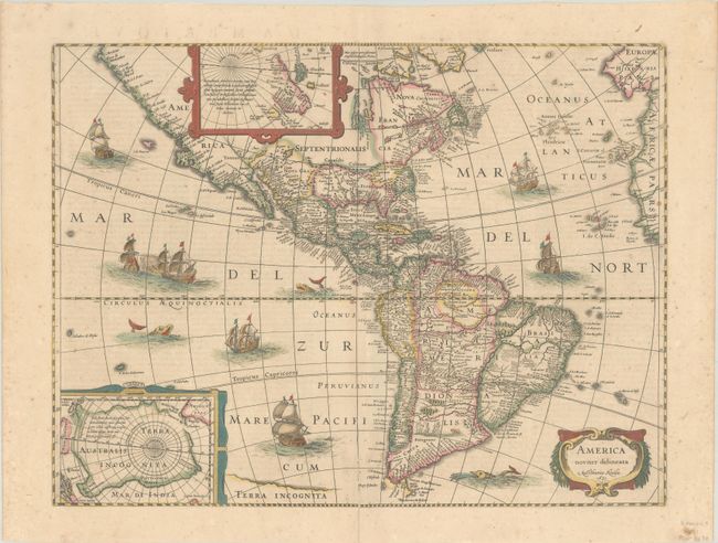
Auction 188, Lot 57
Subject: Western Hemisphere - America
Hondius, Jodocus
America Noviter Delineata, 1618
Size: 24.1 x 18.8 inches (61.2 x 47.8 cm)
Estimate: $7,000 - $8,500
Extremely Rare Map with Four Paneled Borders
Sold for: $6,500
Closed on 6/22/2022
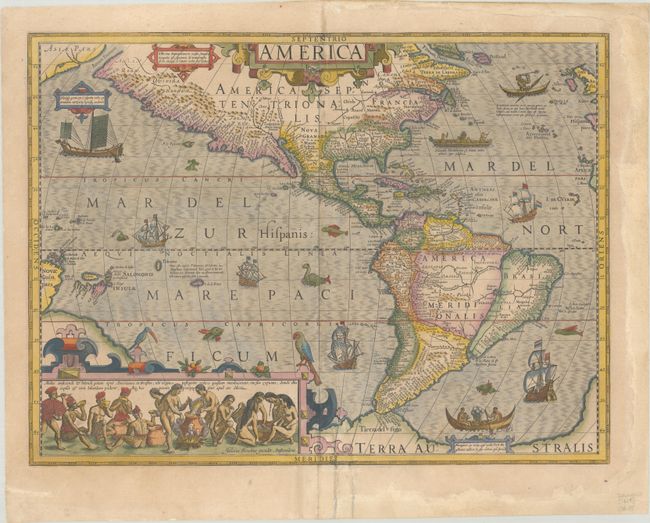
Auction 188, Lot 58
Subject: Western Hemisphere - America
Hondius, Jodocus
America, 1628
Size: 19.8 x 14.8 inches (50.3 x 37.6 cm)
Estimate: $3,250 - $4,000
Hondius' Important Map of the Americas
Sold for: $2,200
Closed on 6/22/2022
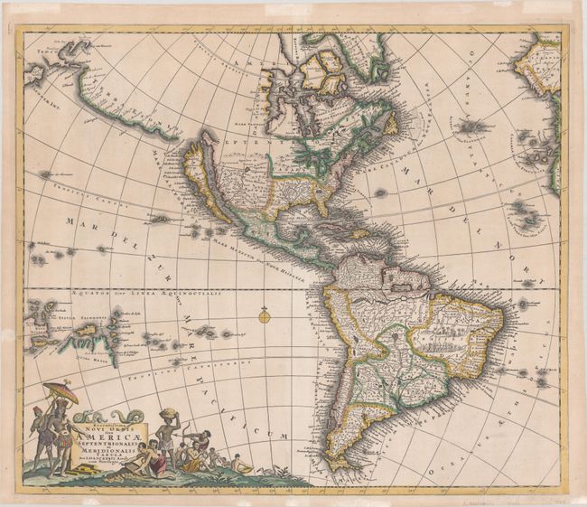
Auction 188, Lot 59
Subject: Western Hemisphere - America
Hondius, Henricus
America Noviter Delineata, 1631
Size: 19.6 x 14.8 inches (49.8 x 37.6 cm)
Estimate: $1,800 - $2,200
Hondius' Decorative Map of the Americas in Full Contemporary Color
Sold for: $1,200
Closed on 6/22/2022
Auction 188, Lot 61
Subject: Western Hemisphere - America
Danckerts, Justus
Recentissima Novi Orbis sive Americae Septentrionalis et Meridionalis Tabula, 1696
Size: 23 x 19.5 inches (58.4 x 49.5 cm)
Estimate: $1,900 - $2,200
Attractive Map of the Americas with Land Bridge to Asia
Sold for: $1,200
Closed on 6/22/2022
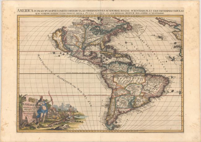
Auction 188, Lot 63
Subject: Western Hemisphere - America
Aa, Pieter van der
L'Amerique Selon les Nouvelles Observations de Messrs. de l'Academie des Sciences, Etc., 1713
Size: 26.3 x 18.6 inches (66.8 x 47.2 cm)
Estimate: $2,750 - $3,500
Features a Large Island of California
Sold for: $1,800
Closed on 6/22/2022
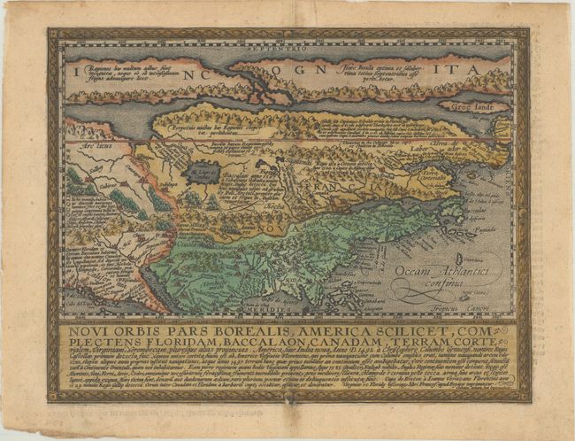
Auction 188, Lot 72
Subject: Colonial North America
Quad, Matthias von Kinckelbach
Novi Orbis Pars Borealis, America Scilicet, Complectens Floridam, Baccalaon, Canadam, Terram Corterialem..., 1600
Size: 11.6 x 8.9 inches (29.5 x 22.6 cm)
Estimate: $3,000 - $3,750
One of the Earliest Maps Devoted to North America
Sold for: $2,200
Closed on 6/22/2022
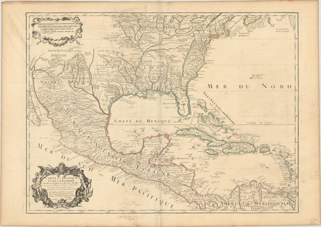
Auction 188, Lot 86
Subject: Colonial Eastern North America
Delisle, Guillaume
Carte du Mexique et de la Floride des Terres Angloises et des Isles Antilles du Cours et des Environs de la Riviere de Mississipi..., 1703
Size: 25.4 x 18.7 inches (64.5 x 47.5 cm)
Estimate: $2,000 - $2,300
Landmark in American Cartography - First Printed Map to Accurately Depict the Mouth of the Mississippi River
Unsold
Closed on 6/22/2022
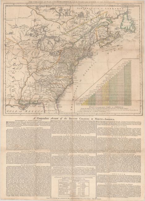
Auction 188, Lot 106
Subject: Colonial Eastern United States & Canada
Sayer & Bennett
The Theatre of War in North America, with the Roads and a Table of the Distances, 1776
Size: 20.1 x 16.1 inches (51.1 x 40.9 cm)
Estimate: $10,000 - $13,000
Early Broadside Informing British Readers of the Brewing War - First State
Unsold
Closed on 6/22/2022

Auction 188, Lot 110
Subject: Colonial Northeastern United States & Canada
Delisle/Covens & Mortier
Carte du Canada ou de la Nouvelle France et des Decouvertes qui y ont ete Faites..., 1730
Size: 22.6 x 19.3 inches (57.4 x 49 cm)
Estimate: $1,200 - $1,500
One of the Most Influential Maps of Canada, Great Lakes & Upper Midwest
Sold for: $850
Closed on 6/22/2022

Auction 188, Lot 131
Subject: Colonial Eastern United States
Delisle, Guillaume
Carte de la Louisiane et du Cours du Mississipi Dressee sur un Grand Nombre de Memoires Entrautres sur ceux de Mr. le Maire, 1718
Size: 25.2 x 19.1 inches (64 x 48.5 cm)
Estimate: $5,500 - $7,000
A Foundation Map for the Mississippi Valley and the First Appearance of Texas on a Printed Map
Sold for: $3,500
Closed on 6/22/2022
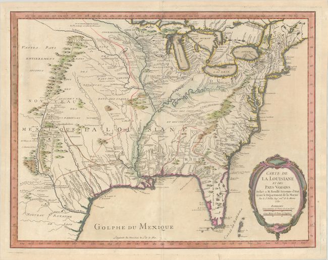
Auction 188, Lot 132
Subject: Colonial Eastern United States
Bellin, Jacques Nicolas
Carte de la Louisiane et des Pays Voisins Dediee a M. Rouille Secretaire d'Etat, Ayant le Departement de la Marine, 1750
Size: 23.9 x 18.6 inches (60.7 x 47.2 cm)
Estimate: $1,600 - $1,900
Bellin's Scarce French and Indian War-Era Map of the Colonial United States - First State
Sold for: $1,000
Closed on 6/22/2022
Auction 188, Lot 140
Subject: Eastern United States, Franklin
Neele, Samuel John
United States, 1813
Size: 11.3 x 8.9 inches (28.7 x 22.6 cm)
Estimate: $1,000 - $1,300
Map Depicting Proposed State of "Franklinia" and Other Short-Lived Territories
Sold for: $1,000
Closed on 6/22/2022

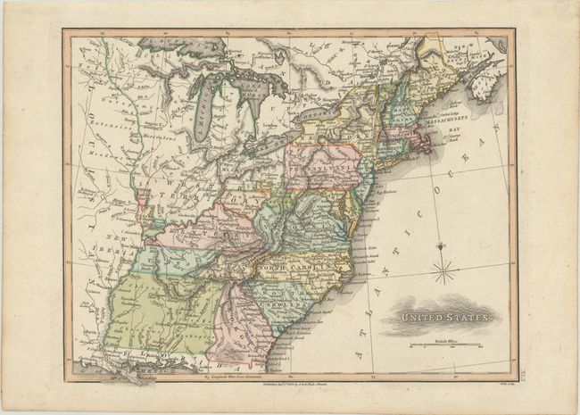
Auction 188, Lot 141
Subject: Eastern United States
Melish, John
United States of America Compiled from the Latest & Best Authorities, 1818
Size: 19.6 x 16.1 inches (49.8 x 40.9 cm)
Estimate: $1,800 - $2,200
Early & Separately Issued Version of Melish's Important Map
Sold for: $2,200
Closed on 6/22/2022

Auction 188, Lot 145
Subject: Colonial New England & Mid-Atlantic United States
Jansson/Valck & Schenk
Nova Belgica et Anglia Nova, 1694
Size: 19.5 x 15.1 inches (49.5 x 38.4 cm)
Estimate: $1,900 - $2,200
Jansson's Influential Map of the East Coast - Valck & Schenk Edition
Unsold
Closed on 6/22/2022

Auction 188, Lot 150
Subject: Colonial Mid-Atlantic United States
Merian, Matthaus
Virginia - Erforshet und Beschriben durch Capitain Iohan Schmidt, 1627
Size: 14.2 x 11.6 inches (36.1 x 29.5 cm)
Estimate: $5,000 - $6,000
The Third Derivative of Capt. John Smith's Foundation Map of Virginia
Sold for: $4,000
Closed on 6/22/2022
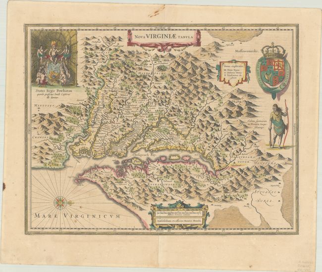
Auction 188, Lot 151
Subject: Colonial Mid-Atlantic United States
Hondius, Henricus
Nova Virginiae Tabula, 1638-58
Size: 19.4 x 15.1 inches (49.3 x 38.4 cm)
Estimate: $1,800 - $2,200
One of the Most Important 17th Century Maps of the Chesapeake Bay
Sold for: $1,200
Closed on 6/22/2022
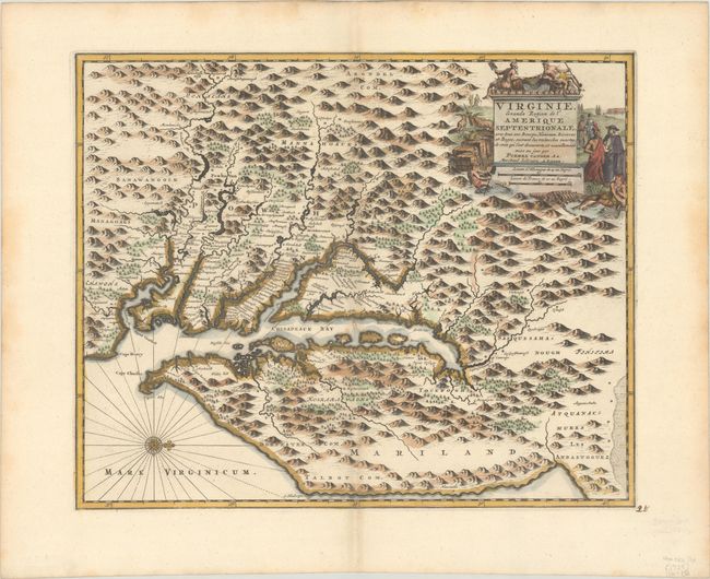
Auction 188, Lot 154
Subject: Colonial Mid-Atlantic United States
Aa, Pieter van der
Virginie, Grande Region de l'Amerique Septentrionale, avec Tous ses Bourgs, Hameaux, Rivieres et Bayes, Suivant les Recherches Exactes de ceux qui l'ont Decouverte…, 1729
Size: 14 x 11.4 inches (35.6 x 29 cm)
Estimate: $1,600 - $1,900
Rare Derivative of John Smith's Map of the Chesapeake Bay
Sold for: $1,200
Closed on 6/22/2022

Auction 188, Lot 156
Subject: Mid-Atlantic United States
Robert de Vaugondy, Didier
Carte de la Virginie et du Maryland Dressee sur la Grande Carte Angloise de Mrs. Josue Fry et Pierre Jefferson, 1793
Size: 25.4 x 19.1 inches (64.5 x 48.5 cm)
Estimate: $1,600 - $1,900
An Essential Map of Virginia and Maryland
Sold for: $1,000
Closed on 6/22/2022
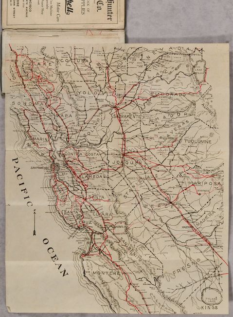
Auction 188, Lot 192
Subject: Northern California
[Map of the Bay Area] [in] Automobile and Motorcycle Road Book California, 1907
Size: 12.5 x 15.4 inches (31.8 x 39.1 cm)
Estimate: $300 - $500
First California Motorist’s Atlas
Sold for: $1,300
Closed on 6/22/2022
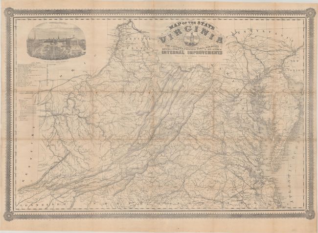
Auction 188, Lot 249
Subject: Virginia, Civil War
West & Johnston
Map of the State of Virginia Containing the Counties, Principal Towns, Railroads Rivers, Canals & All Other Internal Improvements, 1862
Size: 37.4 x 25.6 inches (95 x 65 cm)
Estimate: $7,500 - $9,000
Rare Civil War Map Based on Bucholtz Map of Virginia
Sold for: $4,950
Closed on 6/22/2022

Auction 188, Lot 255
Subject: Southwestern United States & Mexico, California
Fer, Nicolas de
Cette Carte de Californie et du Nouveau Mexique, est Tiree de Celle qui a ete Envoyee par un Grand d'Espagne pour Etre Communiquee a Mrs. de l'Academie Royale des Sciences, 1705
Size: 13.4 x 8.9 inches (34 x 22.6 cm)
Estimate: $1,200 - $1,500
De Fer's Important Map of the Island of California
Sold for: $900
Closed on 6/22/2022
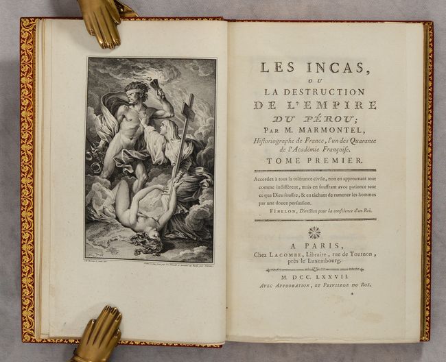
Auction 188, Lot 326
Subject: Peru, Natives
[2 Volumes] Les Incas, ou la Destruction de l'Empire du Perou..., 1777
Size: 5.4 x 8.5 inches (13.7 x 21.6 cm)
Estimate: $1,100 - $1,400
Includes Manuscript Letter by Author and Proof Plates
Sold for: $950
Closed on 6/22/2022
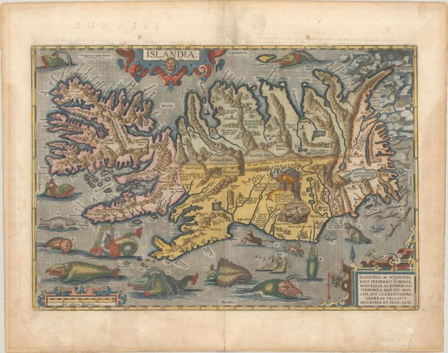
Auction 188, Lot 346
Subject: Iceland
Ortelius, Abraham
Islandia, 1585
Size: 19.4 x 13.3 inches (49.3 x 33.8 cm)
Estimate: $8,000 - $9,500
One of Ortelius' Most Decorative Maps Featuring Fantastical Sea Monsters
Sold for: $11,000
Closed on 6/22/2022
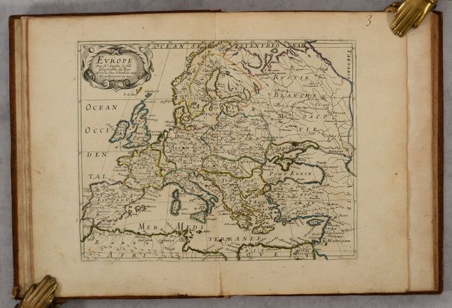
Auction 188, Lot 350
Subject: Europe, Atlases
Sanson, Nicolas Fils
L'Europe, 1650
Size: 7.3 x 9.6 inches (18.5 x 24.4 cm)
Estimate: $1,600 - $1,900
Sanson's Complete Quarto Atlas of Europe in Contemporary Color
Sold for: $1,800
Closed on 6/22/2022
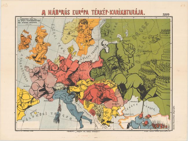
Auction 188, Lot 356
Subject: Europe, World War I
A Haborus Europa Terkep-Karikaturaja, 1914
Size: 18.3 x 13.4 inches (46.5 x 34 cm)
Estimate: $2,000 - $2,400
Rare Hungarian Serio-Comic Map at the Outset of WWI
Sold for: $1,200
Closed on 6/22/2022

Auction 188, Lot 361
Subject: Britain
Jansson, Jan
Britannia Prout Divisa suit Temporibus Anglo-Saxonum, Praesertim Durante Illorum Heptarchia, 1684
Size: 20.8 x 16.6 inches (52.8 x 42.2 cm)
Estimate: $1,500 - $1,800
Jansson's Splendid Heptarchy Map
Unsold
Closed on 6/22/2022
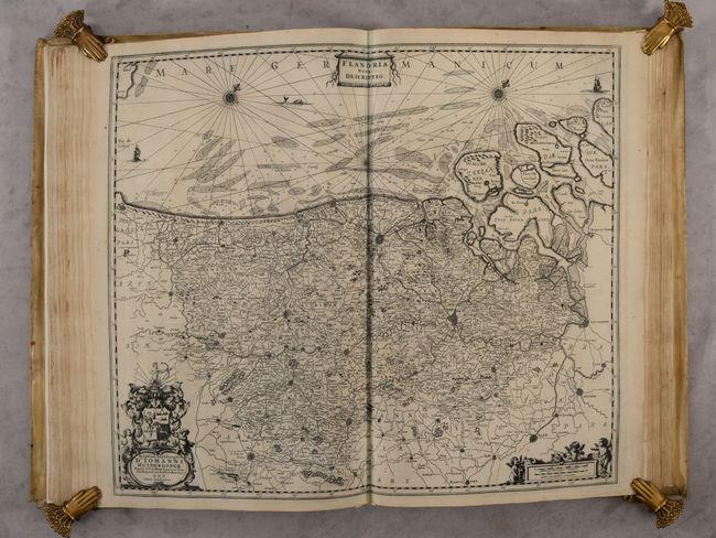
Auction 188, Lot 426
Subject: Low Countries, Atlases
Jansson, Jan
[Nouvel Atlas Tome II], 1652
Size: 13.3 x 20.5 inches (33.8 x 52.1 cm)
Estimate: $5,500 - $6,500
Jansson's Atlas of the Low Countries with 40 Maps in Vellum Binding
Sold for: $4,000
Closed on 6/22/2022
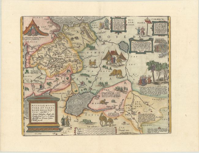
Auction 188, Lot 508
Subject: Russia, Eastern Europe & Central Asia
Ortelius, Abraham
Russiae, Moscoviae et Tartariae Descriptio. Auctore Antonio Ienkensono Anglo..., 1603
Size: 17.6 x 13.9 inches (44.7 x 35.3 cm)
Estimate: $2,000 - $2,300
Ortelius' Map of Russia with a Vignette of Ivan the Terrible
Sold for: $1,500
Closed on 6/22/2022
Auction 188, Lot 510
Subject: Russia in Europe
Blaeu, Willem
Tabula Russiae ex Autographo, quod Delineandum Curavit Foedor Filius Tzaris Boris Desumta ... M.DC.XIIII, 1642
Size: 21.5 x 16.8 inches (54.6 x 42.7 cm)
Estimate: $1,800 - $2,100
Blaeu's Decorative Map of Russia
Sold for: $1,300
Closed on 6/22/2022
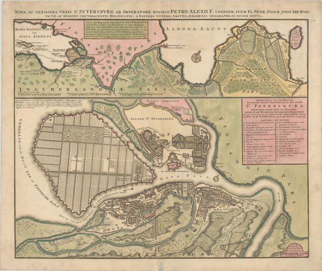
Auction 188, Lot 515
Subject: St. Petersburg, Russia
Ottens, Reiner and Joshua
Nova ac Verissima Urbis St. Petersburg ab Imperatore Russico Petro Alexii F. Conditae, Item Fl. Nevae, Fossae Jussu Imp. Russ..., 1765
Size: 23.2 x 18.8 inches (58.9 x 47.8 cm)
Estimate: $1,200 - $1,500
Map Illustrating Peter the Great's Plans for St. Petersburg
Sold for: $600
Closed on 6/22/2022

Auction 188, Lot 516
Subject: St. Petersburg, Russia
[Lot of 4] Vue de la Neva, Vers l'Occident... [and] Vue de la Neva, Vers l'Orient... [and] Vue des Bords de la Neva, en Remontant la Riviere... [and] Vue des Bords de la Neva, en Descendant la Riviere..., 1783
Size: 25.3 x 8.5 inches (64.3 x 21.6 cm)
Estimate: $1,400 - $1,800
Uncommon Matching Set of Views along the Neva River
Sold for: $1,000
Closed on 6/22/2022

Auction 188, Lot 581
Subject: Adriatic Sea & Ionian Sea
Bellin, Jacques Nicolas
Description Geographique du Golfe de Venise et de la Moree..., 1771
Size: 8 x 10.6 inches (20.3 x 26.9 cm)
Estimate: $2,750 - $3,500
Bellin's Complete Work on the Adriatic Sea and the Western Coasts of Greece
Sold for: $1,600
Closed on 6/22/2022
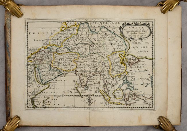
Auction 188, Lot 632
Subject: Asia, Atlases
Sanson, Nicolas
L'Asie en Plusieurs Cartes Nouvelles, et Exactes; & en Divers Traittes de Geographie, et d'Histoire..., 1652
Size: 7.5 x 10.2 inches (19.1 x 25.9 cm)
Estimate: $2,750 - $3,500
First Edition of Sanson's Quarto Atlas of Asia in Contemporary Color
Sold for: $2,100
Closed on 6/22/2022
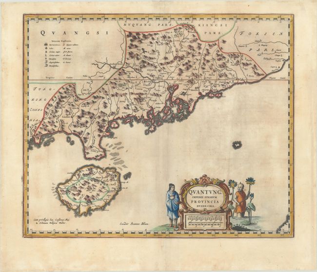
Auction 188, Lot 646
Subject: Southern China
Blaeu, Johannes
Quantung, Imperii Sinarum Provincia Duodecima, 1655
Size: 19.3 x 16 inches (49 x 40.6 cm)
Estimate: $1,900 - $2,200
Old Color Example of Jesuit Map of Hong Kong & Canton
Unsold
Closed on 6/22/2022
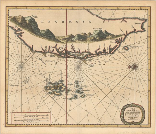
Auction 188, Lot 648
Subject: Taiwan
Aa, Pieter van der
L'Ile de Formosa, ou sont Exactement Marquez les Bancs de Sables, Rochers et Brasses d'Eau..., 1720
Size: 13.8 x 11.4 inches (35.1 x 29 cm)
Estimate: $1,400 - $1,700
Early Map of Taiwan
Sold for: $1,400
Closed on 6/22/2022

Auction 188, Lot 654
Subject: Japan & Korea
Mercator/Hondius
Iaponia, 1634
Size: 17.4 x 13.4 inches (44.2 x 34 cm)
Estimate: $1,600 - $1,900
Hondius' Richly Ornamented Map of Japan
Sold for: $1,100
Closed on 6/22/2022

Auction 188, Lot 661
Subject: Southeast Asia
Jansson, Jan
Indiae Orientalis Nova Descriptio, 1634
Size: 19.8 x 15.3 inches (50.3 x 38.9 cm)
Estimate: $1,200 - $1,500
Includes Discoveries Made by the Dutch "Duyfken" Exploration
Sold for: $800
Closed on 6/22/2022
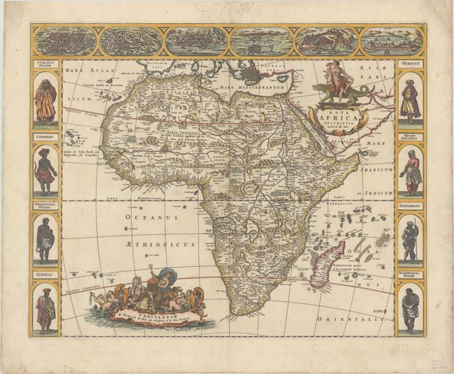
Auction 188, Lot 699
Subject: Africa
Wit, Frederick de
Nova Africa Descriptio, 1660
Size: 21.9 x 17.3 inches (55.6 x 43.9 cm)
Estimate: $2,400 - $3,000
De Wit's Uncommon Carte-a-Figures Map of Africa
Unsold
Closed on 6/22/2022
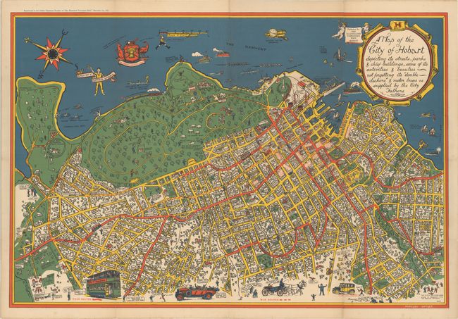
Auction 188, Lot 746
Subject: Hobart, Tasmania
A Map of the City of Hobart Depicting Its Streets, Parks & Chief Buildings, Some of Its Activities & Beauties Not Forgetting Its "Double Deckers" & Motor Buses as Supplied by the City Fathers, 1927
Size: 37 x 25 inches (94 x 63.5 cm)
Estimate: $1,500 - $1,900
Very Rare Bird's-Eye Plan of Hobart
Sold for: $1,000
Closed on 6/22/2022
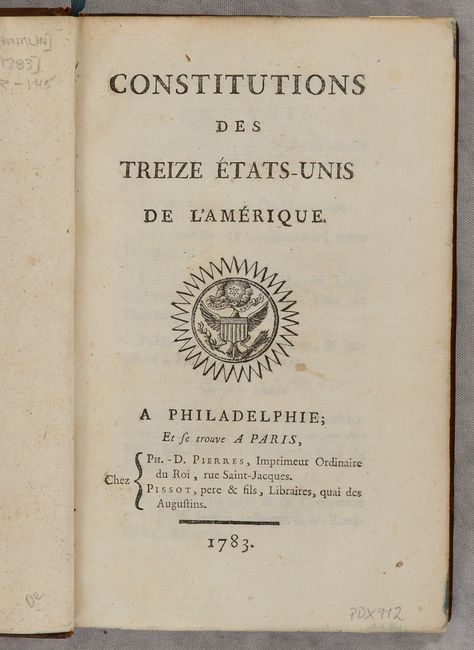
Auction 188, Lot 778
Subject: Document - Early United States
Franklin, Benjamin
Constitutions des Treize Etats-Unis de l'Amerique, 1783
Size: 5.1 x 8 inches (13 x 20.3 cm)
Estimate: $3,000 - $3,750
First French Edition - 600 Copies Printed
Sold for: $2,000
Closed on 6/22/2022
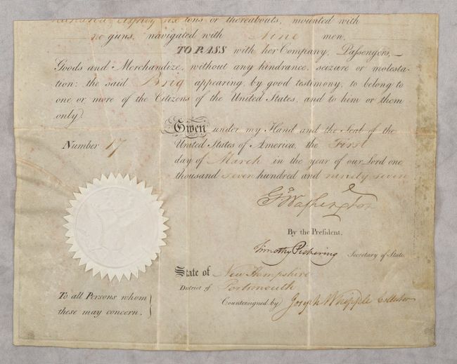
Auction 188, Lot 779
Subject: Document Signed - George Washington
[George Washington Partial Ship's Passport Signed], 1797
Size: 11.8 x 9.3 inches (30 x 23.6 cm)
Estimate: $12,000 - $15,000
Ship's Passport Signed by George Washington
Sold for: $9,500
Closed on 6/22/2022
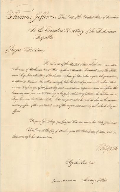
Auction 188, Lot 780
Subject: Document Signed - Thomas Jefferson & James Madison
Jefferson, Thomas
[Thomas Jefferson and James Madision Official Letter to the Executive Directory of the Batavian Republic Signed], 1801
Size: 11.5 x 18.5 inches (29.2 x 47 cm)
Estimate: $5,500 - $7,000
Important Document Assuring Friendship between the United States and the Netherlands
Sold for: $6,000
Closed on 6/22/2022
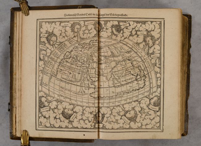
Auction 188, Lot 785
Subject: Atlases
Munster/Petri
Cosmographia, das ist: Beschreibung der Gantzen Welt..., 1628
Size: 9.8 x 15 inches (24.9 x 38.1 cm)
Estimate: $16,000 - $19,000
Largest Edition of Cosmographia with 262 Maps and Views
Sold for: $12,000
Closed on 6/22/2022
58 lots
Page 1 of 2