Showing Featured Lots(remove filter)
Showing results for:Auction 165
Catalog Archive
87 lots
Page 1 of 2
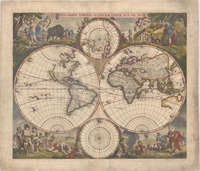
Auction 165, Lot 9
Subject: World
Wit, Frederick de
Nova Orbis Tabula, in Lucem Edita , 1670
Size: 21.6 x 18.3 inches (54.9 x 46.5 cm)
Estimate: $4,500 - $5,500
First State of De Wit's Stunning Double-Hemisphere Map
Sold for: $3,500
Closed on 11/15/2017
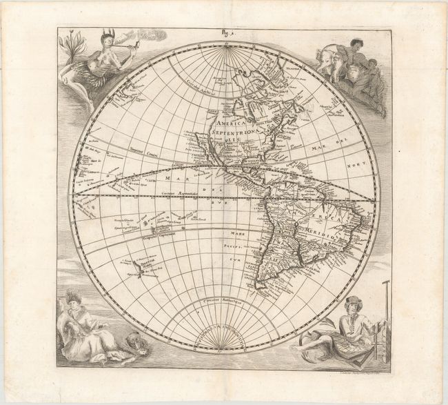
Auction 165, Lot 11
Subject: World
Happel, Everard Werner
[Lot of 2 - Untitled Western & Eastern Hemispheres], 1687
Size: 11.3 x 11.6 inches (28.7 x 29.5 cm)
Estimate: $1,900 - $2,300
Rare and Striking Pair of Hemispheres with Native Figures
Unsold
Closed on 11/15/2017
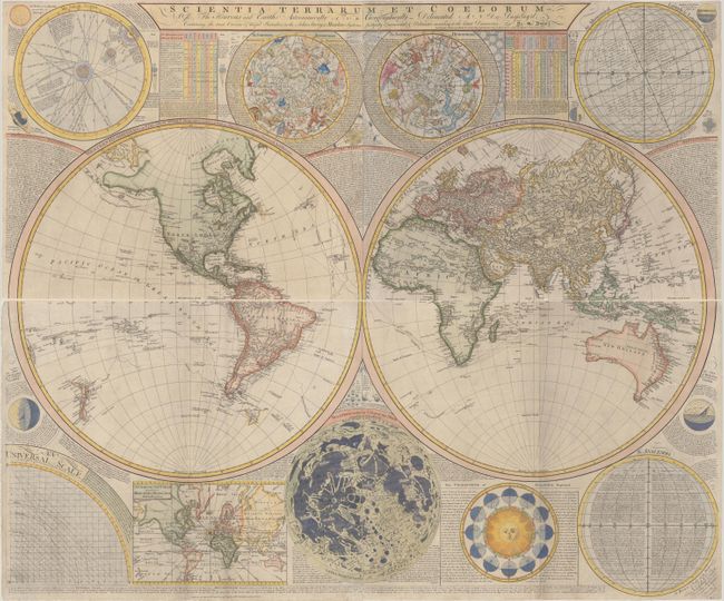
Auction 165, Lot 19
Subject: World
Dunn, Samuel
Scientia Terrarum et Coelorum: or, the Heavens and Earth Astronomically and Geographically Delineated and Display'd..., 1772
Size: 48.8 x 20.6 inches (124 x 52.3 cm)
Estimate: $3,000 - $4,000
First State of Dunn & Sayer's Decorative Wall Map of the World & Heavens
Sold for: $2,200
Closed on 11/15/2017
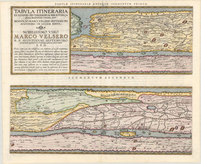
Auction 165, Lot 27
Subject: Ancient World
Ortelius, Abraham
[On 4 Sheets] Tabula Itineraria ex Illustri Peutingerorum Bibliotheca…Nobilissimo Viro Marco Velsero..., 1598
Size: 20.3 x 16.2 inches (51.6 x 41.1 cm)
Estimate: $7,000 - $8,500
Ortelius' Scarce Peutinger Table
Unsold
Closed on 11/15/2017
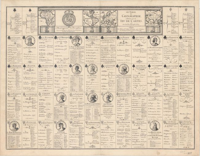
Auction 165, Lot 43
Subject: Cartographic Miscellany, Playing Cards
Duval, Pierre
[Playing Cards] Les Tables de Geographie, Reduites en un Ieu de Cartes, 1669
Size: 21.4 x 16.2 inches (54.4 x 41.1 cm)
Estimate: $3,000 - $4,000
Rare, Uncut Sheet of Playing Cards
Sold for: $2,200
Closed on 11/15/2017
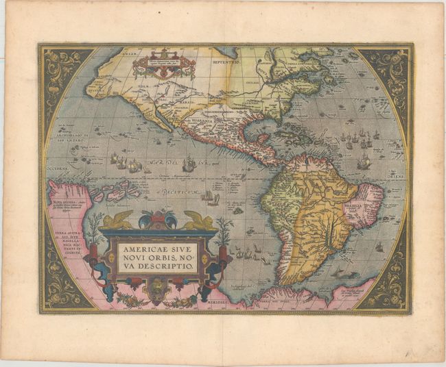
Auction 165, Lot 45
Subject: Western Hemisphere - America
Ortelius, Abraham
Americae sive Novi Orbis, Nova Descriptio, 1603
Size: 19.1 x 14 inches (48.5 x 35.6 cm)
Estimate: $4,750 - $6,000
Ortelius' Influential Map of the New World
Sold for: $3,500
Closed on 11/15/2017
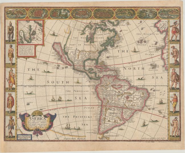
Auction 165, Lot 48
Subject: Western Hemisphere - America
Speed, John
America with Those Known Parts in That Unknowne Worlde Both People and Manner of Buildings , 1626
Size: 20.4 x 15.6 inches (51.8 x 39.6 cm)
Estimate: $5,000 - $6,000
Speed's Popular Carte-a-Figures Map of the Americas
Unsold
Closed on 11/15/2017
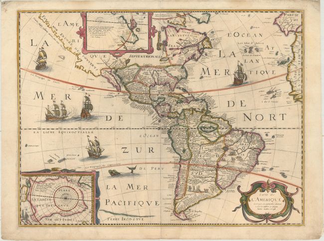
Auction 165, Lot 49
Subject: Western Hemisphere - America
Bertius, Petrus
Carte de l'Amerique Corrigee, et Augmentee, Dessus Toutes les Aultres cy Devant, 1646
Size: 19.6 x 14.9 inches (49.8 x 37.8 cm)
Estimate: $1,600 - $1,900
Scarce Derivative of Hondius' Map of 1618
Sold for: $1,100
Closed on 11/15/2017
Auction 165, Lot 58
Subject: Colonial North America
Sanson/Mariette
Amerique Septentrionale par N. Sanson..., 1669
Size: 22.1 x 15.7 inches (56.1 x 39.9 cm)
Estimate: $2,000 - $2,300
Important Map for Great Lakes Collectors
Sold for: $850
Closed on 11/15/2017
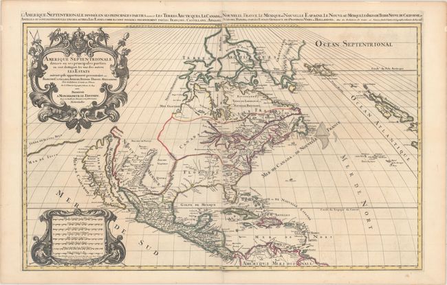
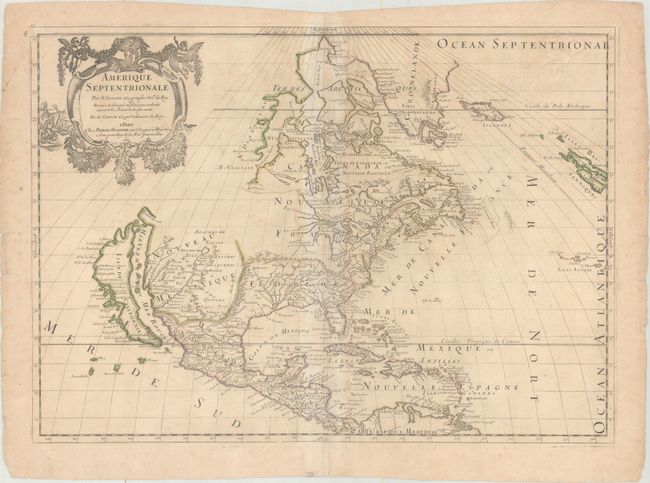
Auction 165, Lot 60
Subject: Colonial North America
Sanson/Mortier
Amerique Septentrionale Divisee en ses Principales Parties, ou sont Distingues les uns des Autres les Estats..., 1696
Size: 34.4 x 21.4 inches (87.4 x 54.4 cm)
Estimate: $3,000 - $3,750
Two-Sheet Map Showing the Island of California
Unsold
Closed on 11/15/2017
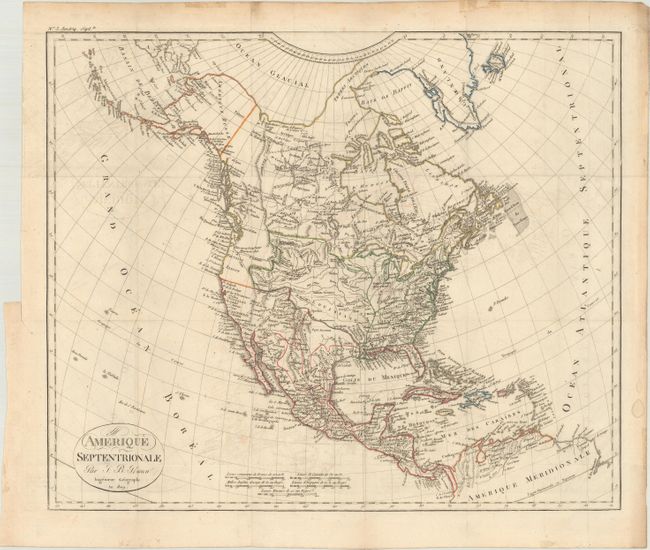
Auction 165, Lot 70
Subject: North America
Poirson, Jean Baptiste
Amerique Septentrionale, 1809
Size: 17.3 x 14.5 inches (43.9 x 36.8 cm)
Estimate: $1,600 - $2,000
One of the Most Advanced, Pre-Lewis & Clark Maps of the Western Interior
Sold for: $1,200
Closed on 11/15/2017
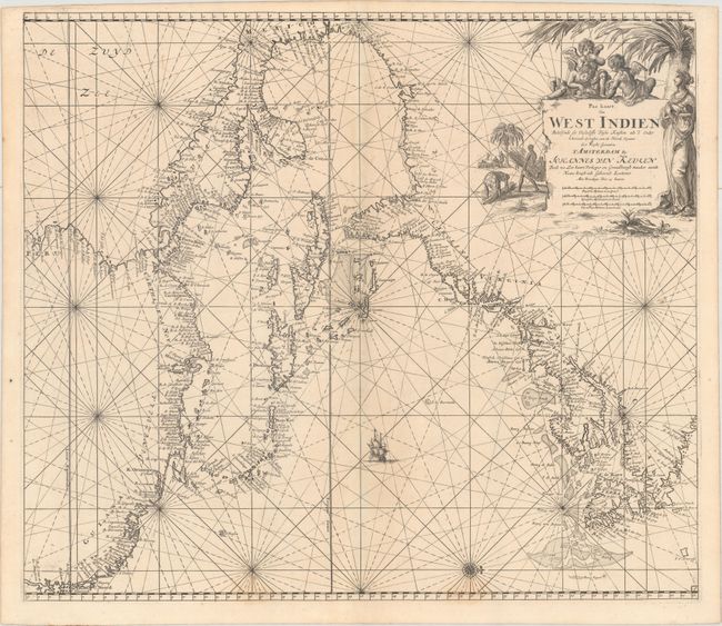
Auction 165, Lot 77
Subject: Colonial Eastern North America & West Indies
Keulen, Johannes van
Pas Kaart van West Indien Behelsende soo Deszelffs Vaste Kusten als d'Onder Behoorende Eylanden aan de Noord Oceaan..., 1687
Size: 23.1 x 20.2 inches (58.7 x 51.3 cm)
Estimate: $4,500 - $5,500
Decorative Chart of the Western Atlantic Coast
Sold for: $3,750
Closed on 11/15/2017
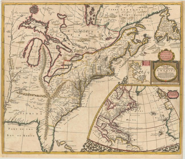
Auction 165, Lot 83
Subject: Colonial Eastern United States & Canada
Senex, John
A New Map of the English Empire in America viz Virginia New York Maryland New Iarsey Carolina New England Pennsylvania Newfoundland New France &c, 1719
Size: 23.6 x 19.9 inches (59.9 x 50.5 cm)
Estimate: $2,400 - $3,000
Important Map of the American Colonies
Unsold
Closed on 11/15/2017
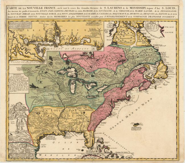
Auction 165, Lot 84
Subject: Colonial Eastern United States & Canada
Ottens/De Fer
Carte de la Nouvelle France, ou se voit le Cours des Grandes Rivieres de S. Laurens & de Mississipi Aujour d'hui S. Louis, aux Environs des Quelles se Trouvent les Etats, Pais, Nations, Peuples &c..., 1745
Size: 21.7 x 19.6 inches (55.1 x 49.8 cm)
Estimate: $2,000 - $2,300
Reduced Version of De Fer's Influential Map of French Possessions in North America
Sold for: $1,400
Closed on 11/15/2017
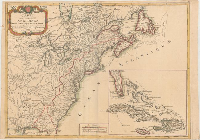
Auction 165, Lot 86
Subject: Colonial Eastern United States & Canada
Imbert, J. Leopold
Carte des Possessions Angloises dans l'Amerique Septentrionale pour Servir d'Intelligence a la Guerre Presente Traduite de l Angloise, 1777
Size: 28.9 x 21.3 inches (73.4 x 54.1 cm)
Estimate: $1,800 - $2,200
First Edition of Important Revolutionary War Map
Sold for: $1,100
Closed on 11/15/2017
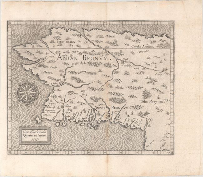
Auction 165, Lot 98
Subject: Alaska & Western Canada
Wytfliet, Cornelis
Limes Occidentis Quivira et Anian, 1597
Size: 11.4 x 9.1 inches (29 x 23.1 cm)
Estimate: $1,800 - $2,100
Early and Imaginary Map of Alaska and the Northwest Passage
Sold for: $1,300
Closed on 11/15/2017
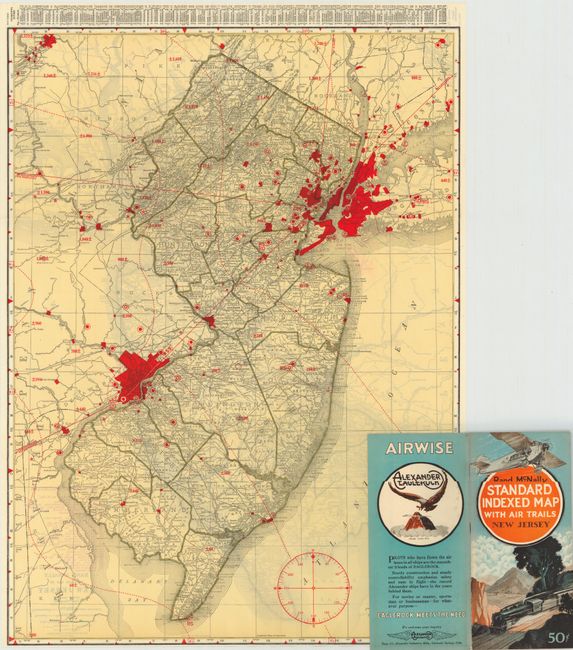
Auction 165, Lot 111
Subject: United States
Rand McNally & Co.
[Lot of 47] [46 Rand McNally Standard Indexed Map with Air Trails] [and] Advance Copy Air Trails Map of Illinois, 1929-30
Size: 25.6 x 35.2 inches (65 x 89.4 cm)
Estimate: $1,000 - $1,300
Rare Rand McNally "Air Trails" Pocket Maps
Sold for: $1,200
Closed on 11/15/2017
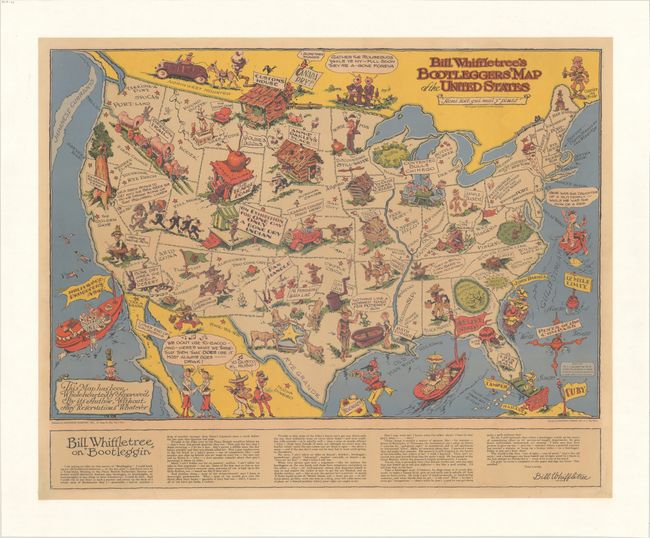
Auction 165, Lot 113
Subject: United States
Bill Whiffletree's Bootleggers' Map of the United States, 1944
Size: 30.2 x 24.1 inches (76.7 x 61.2 cm)
Estimate: $1,600 - $2,000
McCandlish's Humorous Prohibition Map
Unsold
Closed on 11/15/2017
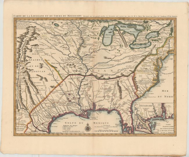
Auction 165, Lot 114
Subject: Colonial Eastern United States, Louisiana Territory
Delisle/Covens & Mortier
Carte de la Louisiane et du Cours du Mississipi Dressee sur un Grand Nombre de Memoires Entr'autres sur ceux de Mr. le Maire, 1730
Size: 23.7 x 17.3 inches (60.2 x 43.9 cm)
Estimate: $2,200 - $2,500
Delisle's Influential Map of the Louisiana Territory
Unsold
Closed on 11/15/2017
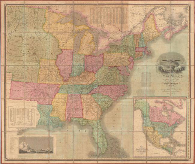
Auction 165, Lot 122
Subject: Eastern United States
Vance, David H.
Map of the United States of North America Compiled from the Latest and Most Authentic Information, 1825
Size: 61.6 x 51.8 inches (156.5 x 131.6 cm)
Estimate: $6,000 - $7,500
First Edition of Vance's Scarce, Large Map of the United States
Sold for: $3,500
Closed on 11/15/2017
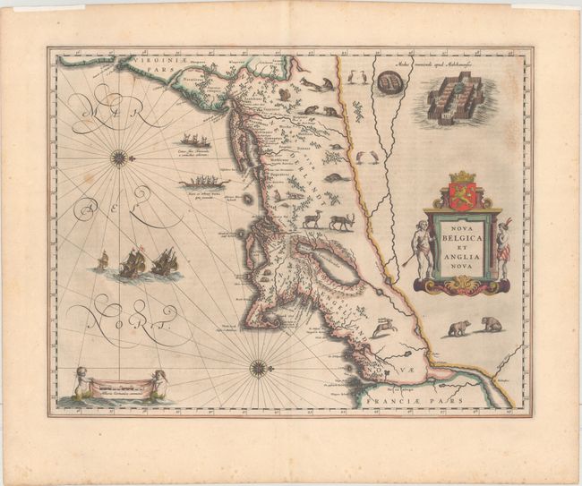
Auction 165, Lot 128
Subject: Colonial New England & Mid-Atlantic United States
Blaeu, Willem
Nova Belgica et Anglia Nova, 1635
Size: 19.9 x 15.3 inches (50.5 x 38.9 cm)
Estimate: $2,300 - $2,750
Important Map of Colonial New England and the Mid-Atlantic
Sold for: $1,200
Closed on 11/15/2017
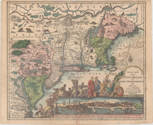
Auction 165, Lot 131
Subject: Colonial New England & Mid-Atlantic United States
Seutter/Lotter
Recens Edita Totius Novi Belgii, in America Septentrionali siti, Delineatio Cura et Sumtibus, 1757
Size: 23 x 19.7 inches (58.4 x 50 cm)
Estimate: $2,500 - $3,250
Decorative Edition from Jansson-Visscher Series with View of Manhattan
Sold for: $1,600
Closed on 11/15/2017
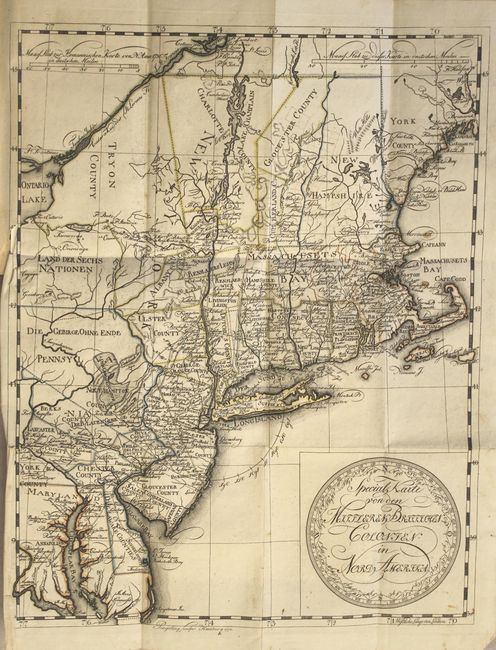
Auction 165, Lot 132
Subject: Colonial New England & Mid-Atlantic United States
Leiste/Pingeling
Special Karte von den Mittleren Britisshen Colonien in Nord Amerika... [bound in] Beschreibung des Brittischen Amerika zur Ersparung der Englischen Karten..., 1778
Size: 11.7 x 14.8 inches (29.7 x 37.6 cm)
Estimate: $2,000 - $2,300
Scarce Revolutionary War Map
Unsold
Closed on 11/15/2017
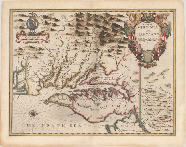
Auction 165, Lot 136
Subject: Colonial Mid-Atlantic United States
Speed/Lamb
A Map of Virginia and Maryland, 1676
Size: 19.7 x 14.9 inches (50 x 37.8 cm)
Estimate: $4,000 - $5,000
The First Printed Map to Draw Upon the Legendary Herrman Map of the Chesapeake Bay with Rare Blank Verso
Sold for: $2,400
Closed on 11/15/2017
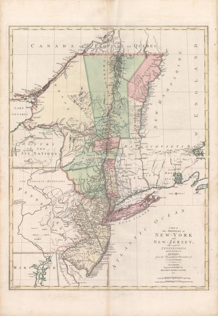
Auction 165, Lot 138
Subject: Colonial Mid-Atlantic United States
Lotter, Mathias Albrecht
[On 2 Sheets] A Map of the Provinces of New-York and New-Jersey, with a Part of Pennsylvania and the Province of Quebec. From the Topographical Observations of C.J. Sauthier, 1777
Size: 22.4 x 15 inches (56.9 x 38.1 cm)
Estimate: $2,400 - $3,000
Important Revolutionary War Map
Unsold
Closed on 11/15/2017
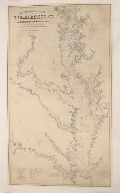
Auction 165, Lot 142
Subject: Mid-Atlantic United States
Eldridge, George
Eldridge's Chart of Chesapeake Bay, with the James, York, Rappahannock and Potomac Rivers, 1874
Size: 32.3 x 56.4 inches (82 x 143.3 cm)
Estimate: $1,600 - $2,000
Impressive, Detailed Chart of the Chesapeake Bay
Sold for: $1,600
Closed on 11/15/2017
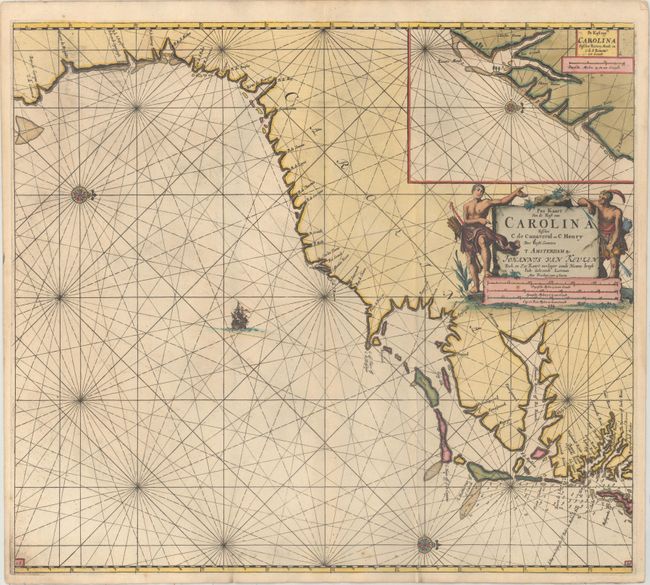
Auction 165, Lot 148
Subject: Colonial Southeast United States
Keulen, Johannes van
Pas Kaart van de Kust van Carolina Tusschen C de Canaveral en C Henry, 1702
Size: 22.8 x 20.3 inches (57.9 x 51.6 cm)
Estimate: $3,500 - $4,500
Scarce Dutch Chart of the Carolinas
Sold for: $2,500
Closed on 11/15/2017
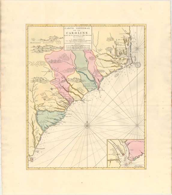
Auction 165, Lot 149
Subject: Colonial Southeastern United States
Covens & Mortier
Carte General de la Caroline. Dressee sur les Memoires le Plus Nouveaux par le Sieua S..., 1730
Size: 18.4 x 22.3 inches (46.7 x 56.6 cm)
Estimate: $3,250 - $4,000
The First Map of the Carolinas Published Outside of England
Unsold
Closed on 11/15/2017
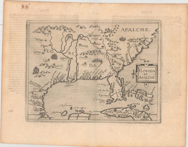
Auction 165, Lot 157
Subject: Colonial Southern United States
Metellus, Natalius Sequanus
Florida et Apalche, 1598
Size: 9.6 x 7.3 inches (24.4 x 18.5 cm)
Estimate: $4,500 - $6,000
One of the Earliest Obtainable Maps of Florida & the Southeast
Sold for: $3,250
Closed on 11/15/2017
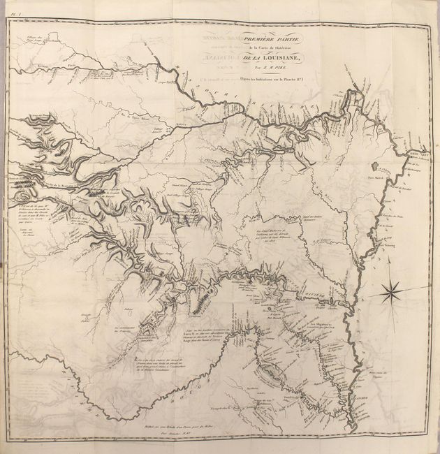
Auction 165, Lot 166
Subject: Central United States
Pike, Zebulon
Voyage au Noveau-Mexique, a la Suite d'une Expedition Ordonnee par le Gouvernement des Etats-Unis, pour Reconnoitre les Sources des Rivieres Arkansas, Kanses, La Plate et Pierre-Jaune..., 1812
Size: 5.3 x 8.3 inches (13.5 x 21.1 cm)
Estimate: $3,500 - $4,250
First French Edition of Pike's Cornerstone Report
Sold for: $2,000
Closed on 11/15/2017
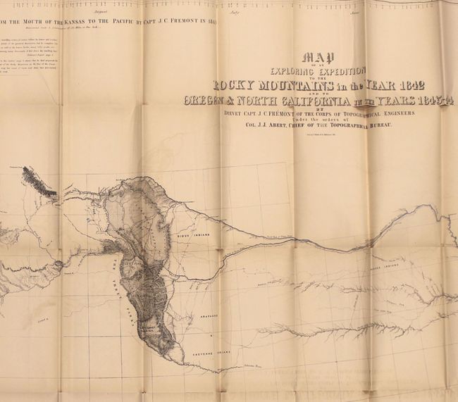
Auction 165, Lot 178
Subject: Western United States
Fremont/Preuss
Map of an Exploring Expedition to the Rocky Mountains in the Year 1842 and to Oregon & North California in the Years 1843-44 [with] Report of The Exploring Expedition to the Rocky Mountains…, 1845
Size: 51 x 30.5 inches (129.5 x 77.5 cm)
Estimate: $1,400 - $1,700
Fremont's Large Map of the American West
Unsold
Closed on 11/15/2017
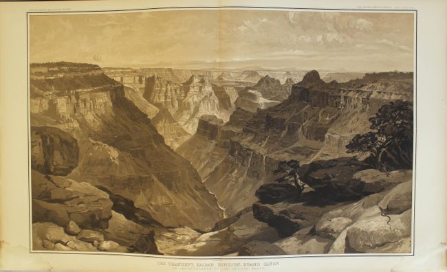
Auction 165, Lot 199
Subject: Grand Canyon, Arizona
Dutton, Clarence Edward
[2 Volumes] Atlas to Accompany the Monograph on the Tertiary History of the Grand Canon District [and] Tertiary History of the Grand Canon District..., 1882
Size: 18 x 20.3 inches (45.7 x 51.6 cm)
Estimate: $4,000 - $5,000
Dutton's Famous Atlas of the Grand Canyon Complete with Report
Unsold
Closed on 11/15/2017
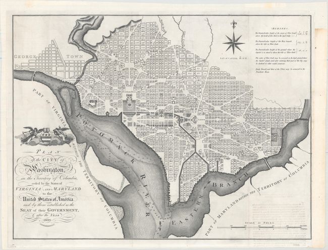
Auction 165, Lot 221
Subject: Washington, D.C.
Russell, John C.
Plan of the City of Washington, in the Territory of Columbia, Ceded by the States of Virginia and Maryland to the United States of America, and by Them Established as the Seat of Their Government, After the Year 1800, 1795
Size: 20.9 x 15.9 inches (53.1 x 40.4 cm)
Estimate: $2,300 - $2,750
Rare, Early Large Format Map of Washington D.C.
Sold for: $1,300
Closed on 11/15/2017
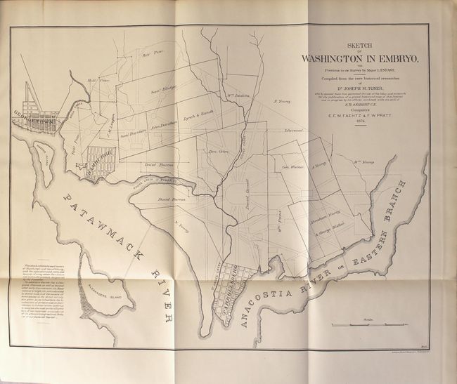
Auction 165, Lot 224
Subject: Washington, D.C.
[3 Maps Bound in] Washington in Embryo; or, the National Capital from 1791 to 1800. The Origin of All Rights and Titles to Property in Washington, D.C..., 1874
Size: 10.6 x 14.1 inches (26.9 x 35.8 cm)
Estimate: $500 - $650
Scarce Publication Detailing Land Ownership Prior to the District of Columbia
Sold for: $750
Closed on 11/15/2017
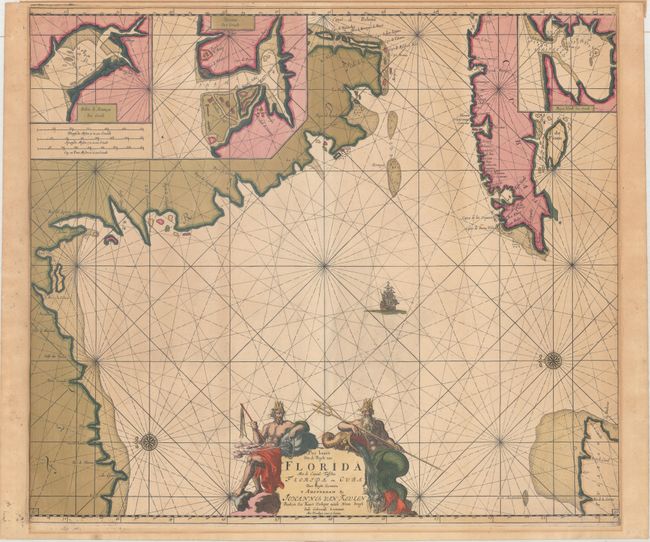
Auction 165, Lot 230
Subject: Florida & Cuba
Keulen, Johannes van
Pas Kaart van de Boght van Florida met de Canaal Tusschen Florida en Cuba, 1687
Size: 22.9 x 20.1 inches (58.2 x 51.1 cm)
Estimate: $3,750 - $4,500
One of the First Charts of the Florida Gulf Coast in Full Original Color
Unsold
Closed on 11/15/2017
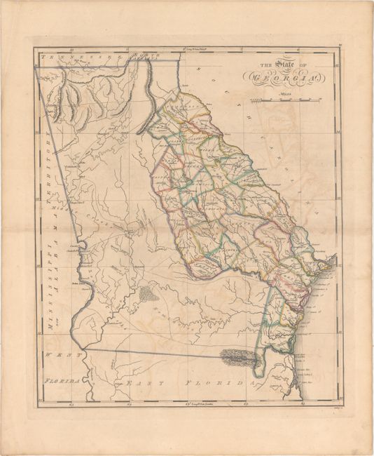
Auction 165, Lot 243
Subject: Georgia
Carey, Mathew
The State of Georgia, 1818
Size: 14.6 x 17.2 inches (37.1 x 43.7 cm)
Estimate: $1,900 - $2,300
Rare, Early Map of Georgia with its Modern Boundary
Unsold
Closed on 11/15/2017
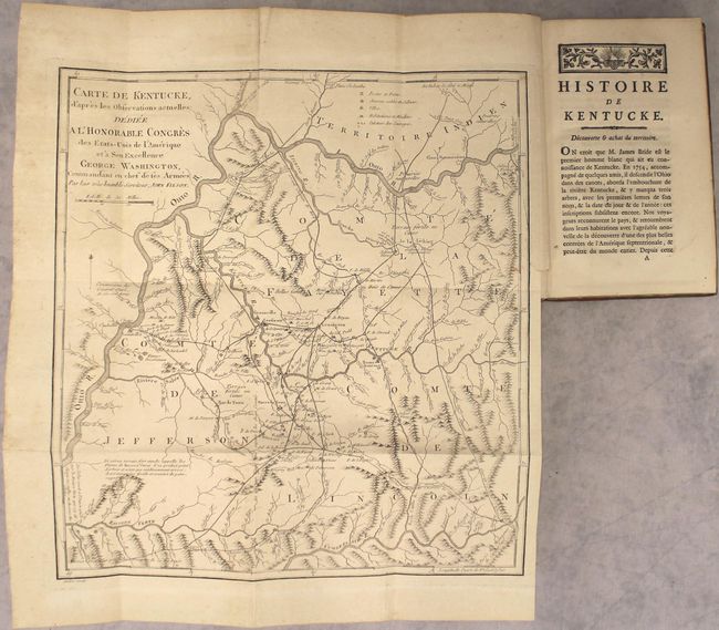
Auction 165, Lot 248
Subject: Kentucky
Filson, John
Carte de Kentucke, d'Apres les Observations Actuelles; Dediee a l'Honorable Congres des Etats-Unis de l'Amerique... [in book] Histoire de Kentucke, Nouvelle Colonie a l'Ouest de la Virginie..., 1785
Size: 12.6 x 13.6 inches (32 x 34.5 cm)
Estimate: $2,750 - $3,500
The First Map of Kentucky
Sold for: $1,600
Closed on 11/15/2017
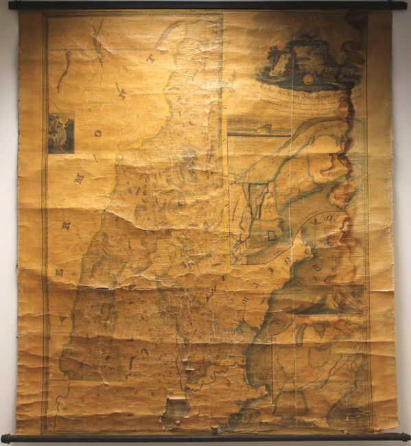
Auction 165, Lot 267
Subject: New Hampshire
Carrigan, Philip
New Hampshire by Recent Survey Made Under the Supreme Authority and Published According to Law, 1816
Size: 46.7 x 59.7 inches (118.6 x 151.6 cm)
Estimate: $4,000 - $6,000
The First State-Sponsored Map of New Hampshire
Unsold
Closed on 11/15/2017
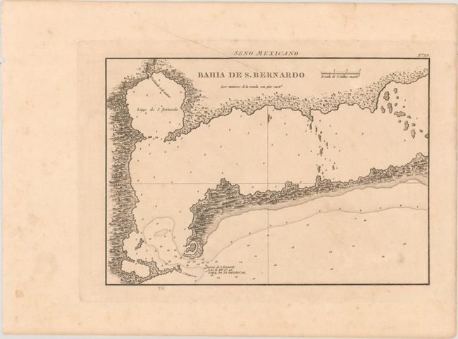
Auction 165, Lot 306
Subject: Matagorda Bay, Texas
Direccion de Hidrografia
Bahia de S. Bernardo, 1809
Size: 10.2 x 7.2 inches (25.9 x 18.3 cm)
Estimate: $550 - $700
First Engraved Map of Matagorda Bay
Sold for: $275
Closed on 11/15/2017
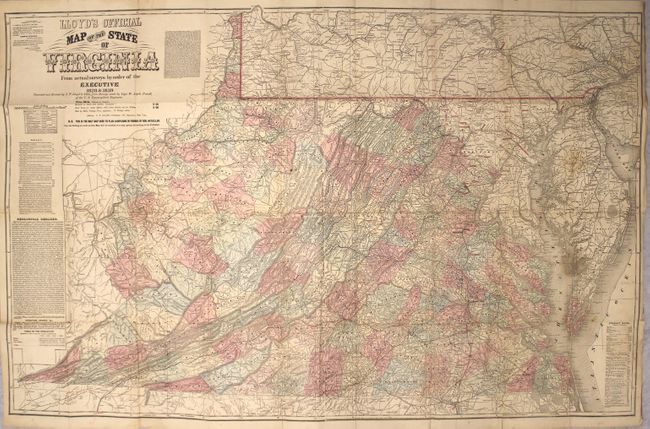
Auction 165, Lot 309
Subject: Virginia
Lloyd, James T.
Lloyd's Official Map of the State of Virginia from Actual Surveys by Order of the Executive 1828 & 1859..., 1862
Size: 47.1 x 30.3 inches (119.6 x 77 cm)
Estimate: $3,500 - $4,500
Rare London Issue of Lloyd's Civil War Map of Virginia with Racist Commentary
Sold for: $2,200
Closed on 11/15/2017
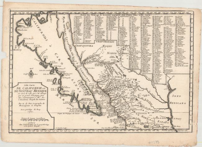
Auction 165, Lot 313
Subject: Southwestern United States & Mexico, California
Fer, Nicolas de
Cette Carte de Californie et du Nouveau Mexique..., 1700
Size: 13.5 x 9 inches (34.3 x 22.9 cm)
Estimate: $1,200 - $1,500
De Fer's Important Map of the Island of California
Sold for: $650
Closed on 11/15/2017
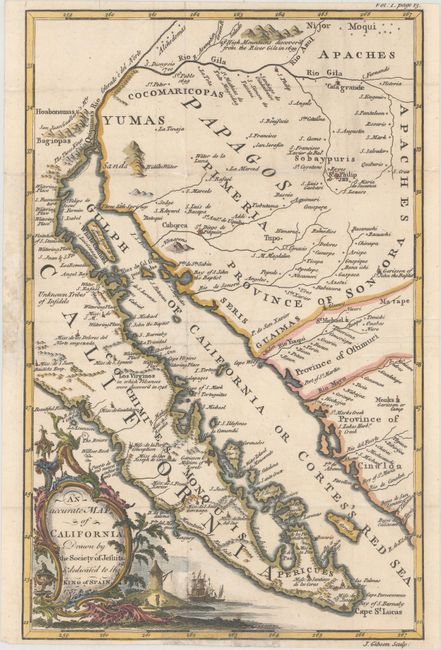
Auction 165, Lot 314
Subject: Southwestern United States & Mexico
Gibson, John
An Accurate Map of California, Drawn by the Society of Jesuits & Dedicated to the King of Spain, 1757
Size: 7.9 x 12.4 inches (20.1 x 31.5 cm)
Estimate: $800 - $1,000
Important Map for California and Baja California Collectors
Sold for: $400
Closed on 11/15/2017
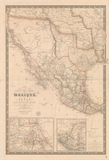
Auction 165, Lot 319
Subject: Western United States & Mexico, Texas, California
Brue, Adrien Hubert
Nouvelle Carte du Mexique, du Texas et d'une Partie des Etats Limitrophes..., 1840
Size: 25.9 x 36.6 inches (65.8 x 93 cm)
Estimate: $3,000 - $3,750
Brue's Landmark Map of the West Featuring the Republic of Texas
Unsold
Closed on 11/15/2017
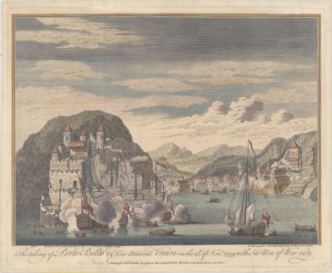
Auction 165, Lot 335
Subject: Portobelo, Panama
Bowles, Thomas
The Taking of Porto Bello by Vice Admiral Vernon on the 22d of Nov. 1739 with Six Men of War Only, 1743
Size: 13.9 x 10.4 inches (35.3 x 26.4 cm)
Estimate: $600 - $800
Rare View of Battle of Portobelo
Sold for: $2,000
Closed on 11/15/2017
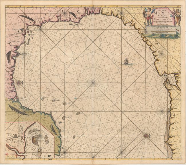
Auction 165, Lot 346
Subject: Gulf of Mexico
Keulen, Johannes van
Pas Kaart van de Golff van Mexico, 1687
Size: 23.2 x 20.3 inches (58.9 x 51.6 cm)
Estimate: $1,600 - $1,900
The First Sea Chart of the Western Portion of the Gulf of Mexico
Unsold
Closed on 11/15/2017
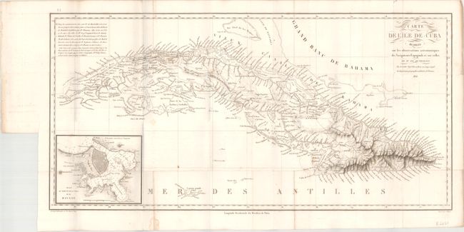
Auction 165, Lot 354
Subject: Cuba
Humboldt, Friedrich Heinrich Alexander von
Carte de l'Ile de Cuba... [with 2 Volumes] Essai Politique sur l'Ile de Cuba, 1826
Size: 25.1 x 12.4 inches (63.8 x 31.5 cm)
Estimate: $2,300 - $2,750
First Edition of Humboldt's Work on Cuba
Sold for: $1,400
Closed on 11/15/2017
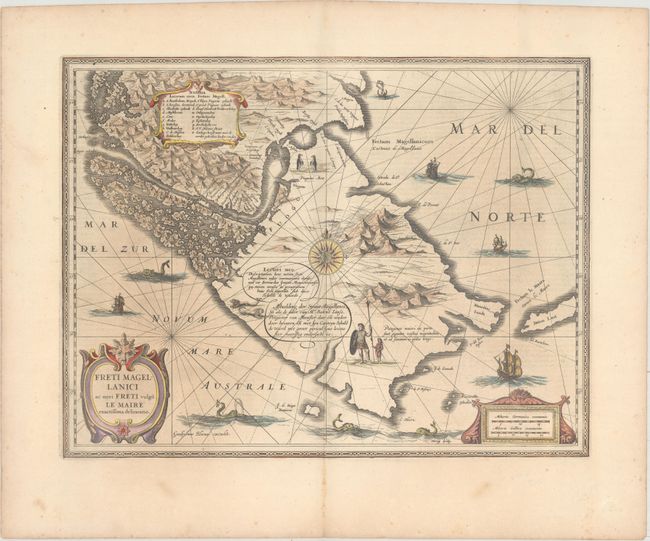
Auction 165, Lot 398
Subject: Strait of Magellan
Hondius/Blaeu
Freti Magellanici ac Novi Freti Vulgo Le Maire Exactissima Delineatio, 1635
Size: 19.4 x 14.8 inches (49.3 x 37.6 cm)
Estimate: $600 - $800
Blaeu's Scarce First Map of the Strait of Magellan
Sold for: $450
Closed on 11/15/2017
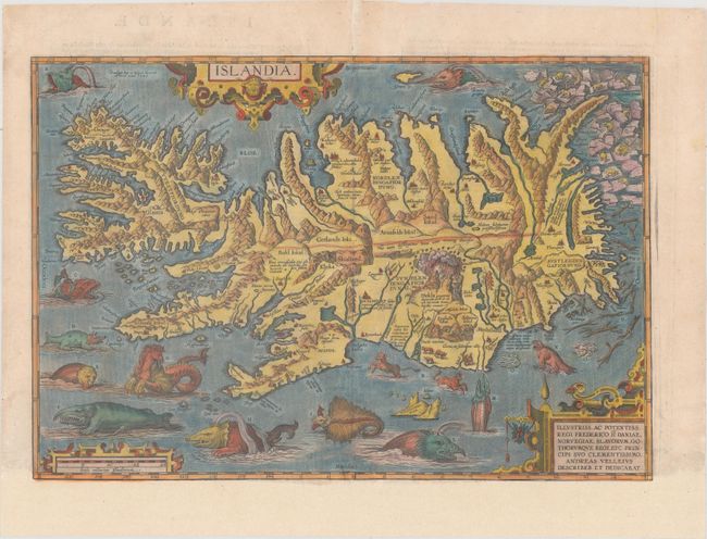
Auction 165, Lot 410
Subject: Iceland
Ortelius, Abraham
Islandia, 1585
Size: 19.4 x 13.3 inches (49.3 x 33.8 cm)
Estimate: $6,000 - $7,500
One of Ortelius' Most Decorative Maps Featuring Fantastical Sea Monsters
Sold for: $4,000
Closed on 11/15/2017
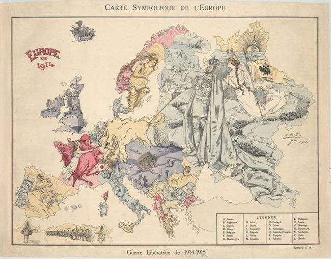
Auction 165, Lot 418
Subject: Europe, World War I
Carte Symbolique de l'Europe / Europe en 1914, 1915
Size: 22.3 x 16.4 inches (56.6 x 41.7 cm)
Estimate: $1,500 - $1,800
Rare Satirical Map of Europe at Start of World War I
Sold for: $900
Closed on 11/15/2017
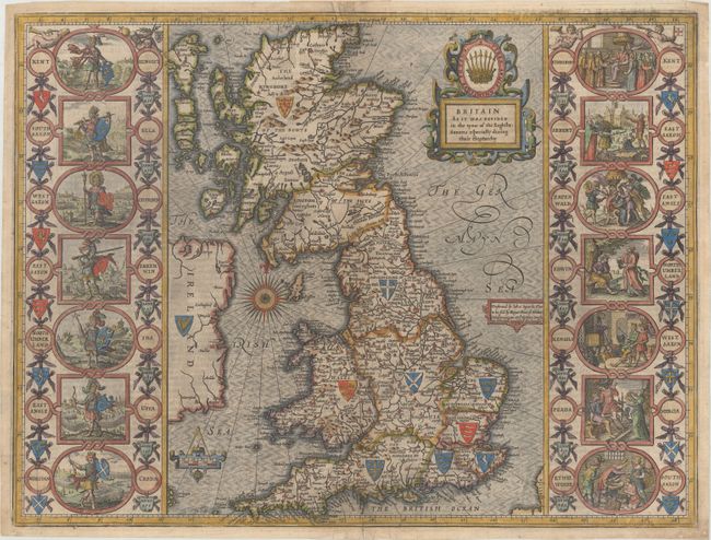
Auction 165, Lot 421
Subject: Britain
Speed, John
Britain as It Was Devided in the Tyme of the Englishe-Saxons Especially During Their Heptarchy, 1650
Size: 19.9 x 15 inches (50.5 x 38.1 cm)
Estimate: $3,000 - $3,750
Speed's "Heptarchy" Map Depicting the Saxon Kingdoms
Sold for: $2,000
Closed on 11/15/2017
87 lots
Page 1 of 2