Showing Featured Lots(remove filter)
Showing results for:Auction 155
Catalog Archive
63 lots
Page 1 of 2
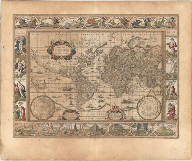
Auction 155, Lot 10
Subject: World
Blaeu, Willem
Nova Totius Terrarum Orbis Geographica ac Hydrographica Tabula, 1640
Size: 21.4 x 16 inches (54.4 x 40.6 cm)
Estimate: $9,500 - $12,000
Blaeu's Magnificent Carte-a-Figures World Map
Unsold
Closed on 11/18/2015
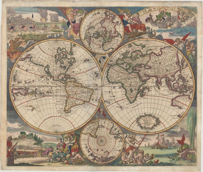
Auction 155, Lot 12
Subject: World
Tavernier, Melchior
[Lot of 2] Carte de l'Amerique Nouvellement Dressee Suivant les Nouvelles Descouvertes... [and] Carte Nouvelle de l'Europe Asie & Afrique..., 1661
Size: 11.8 x 11.8 inches (30 x 30 cm)
Estimate: $3,000 - $3,750
Elegant World Map in Two Separate Hemispheres
Sold for: $2,200
Closed on 11/18/2015
Auction 155, Lot 14
Subject: World
Danckerts, Justus
Nova Totius Terrarum Orbis Tabula, 1680
Size: 22.8 x 19.2 inches (57.9 x 48.8 cm)
Estimate: $3,750 - $4,500
Danckerts' Decorative Double-Hemisphere Map
Sold for: $2,100
Closed on 11/18/2015
Auction 155, Lot 30
Subject: Ancient World
Macrobius, Ambrosius Aurelius Theodo
Macrobii Ambrosii Aurelii Theodosij, Viri Consularis, & Illustris..., 1565
Size: 4.1 x 6.1 inches (10.4 x 15.5 cm)
Estimate: $1,400 - $1,700
Macrobius' Miniature Ancient World Map
Sold for: $1,000
Closed on 11/18/2015
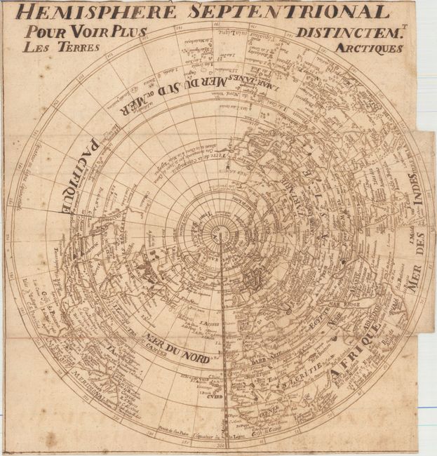
Auction 155, Lot 41
Subject: North Pole
Anon.
Hemisphere Septentrional pour Voir Plus Distinctem.t les Terres Arctiques, 1730
Size: 12.7 x 13.4 inches (32.3 x 34 cm)
Estimate: $475 - $600
Manuscript Map of Delisle's Map of the Northern Hemisphere
Sold for: $300
Closed on 11/18/2015
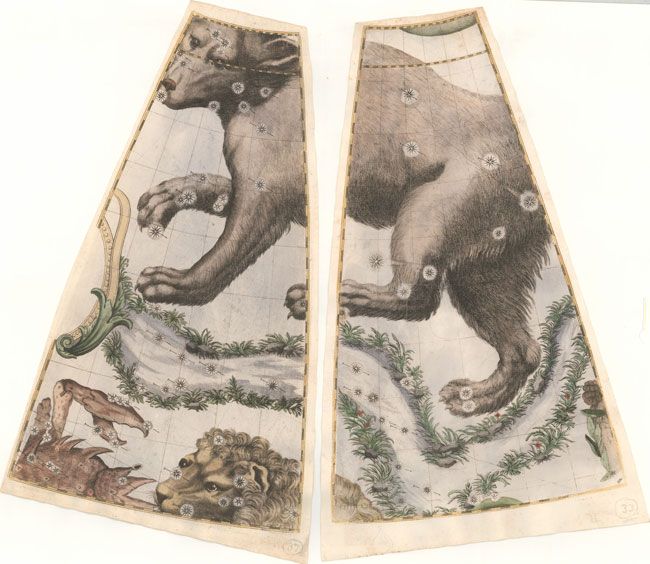
Auction 155, Lot 46
Subject: Celestial
Coronelli, Vincenzo Maria
[Lot of 2 - Celestial Gores], 1693
Size: 10.1 x 16.9 inches (25.7 x 42.9 cm)
Estimate: $1,600 - $1,800
Matching Pair of Rare Coronelli Celestial Gores
Sold for: $1,200
Closed on 11/18/2015
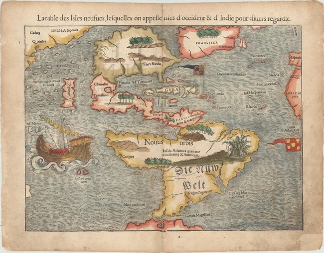
Auction 155, Lot 54
Subject: Western Hemisphere - America
Munster, Sebastian
La Table des Isles Neufues, Lesquelles on Appelle Isles d'Occident & d'Indie pour Diuers Regardz, 1552
Size: 13.6 x 10.2 inches (34.5 x 25.9 cm)
Estimate: $5,500 - $7,000
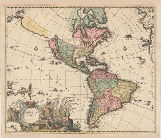
One of the Most Important 16th Century Maps of the New World
Sold for: $3,500
Closed on 11/18/2015
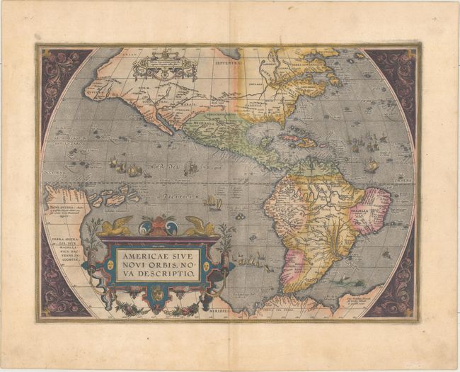
Auction 155, Lot 55
Subject: Western Hemisphere - America
Ortelius, Abraham
Americae sive Novi Orbis, Nova Descriptio, 1587
Size: 18.9 x 13.9 inches (48 x 35.3 cm)
Estimate: $6,000 - $7,000
Ortelius' Influential Map of the New World
Sold for: $4,500
Closed on 11/18/2015
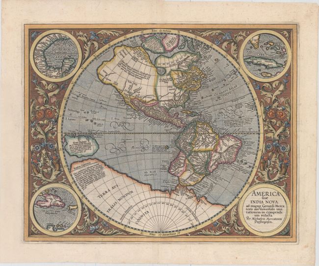
Auction 155, Lot 57
Subject: Western Hemisphere - America
Mercator, Michael
America sive India Nova, ad Magnae Gerardi Mercatoris aui Universalis Imitationem in Compendium Redacta, 1613
Size: 18.1 x 14.5 inches (46 x 36.8 cm)
Estimate: $5,000 - $6,500
Mercator's Foundation Map for the Americas
Sold for: $3,000
Closed on 11/18/2015
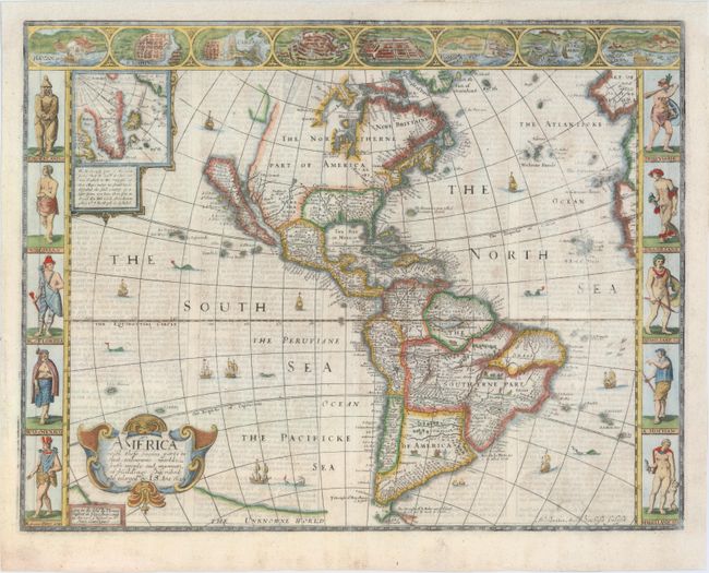
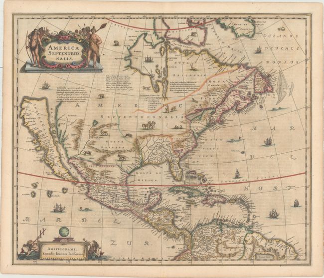
Auction 155, Lot 58
Subject: Western Hemisphere - America
Speed, John
America with Those Known Parts in That Unknowne Worlde Both People and Manner of Buildings Discribed and Inlarged, 1626
Size: 20.3 x 15.6 inches (51.6 x 39.6 cm)
Estimate: $5,500 - $7,000
Speed's Popular Carte-a-Figures Map of the Americas
Sold for: $4,000
Closed on 11/18/2015
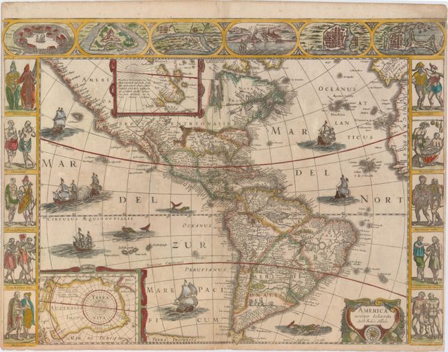
Auction 155, Lot 60
Subject: Western Hemisphere - America
Hondius/Jansson
America Noviter Delineata, 1632
Size: 22 x 16.3 inches (55.9 x 41.4 cm)
Estimate: $7,000 - $8,500
Jansson's Rare Carte-a-Figures Map of the Americas
Unsold
Closed on 11/18/2015
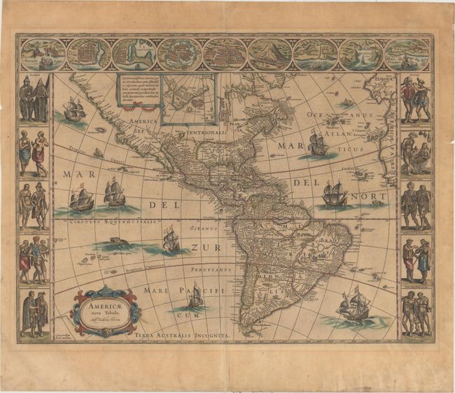
Auction 155, Lot 62
Subject: Western Hemisphere - America
Blaeu, Willem
Americae Nova Tabula, 1640
Size: 22 x 16.3 inches (55.9 x 41.4 cm)
Estimate: $4,000 - $5,000
Blaeu's Stunning Carte-a-Figures Map of the Americas
Unsold
Closed on 11/18/2015
Auction 155, Lot 65
Subject: Western Hemisphere - America
Allard, Carel
Recentissima Novi Orbis sive Americae Septentrionalis et Meridionalis Tabula, 1696
Size: 22.9 x 19.5 inches (58.2 x 49.5 cm)
Estimate: $2,200 - $2,500
Uncommon First State of Allard's Map of the Western Hemisphere
Sold for: $1,100
Closed on 11/18/2015
Auction 155, Lot 75
Subject: North America
Hondius/Jansson
America Septentrionalis, 1644
Size: 21.7 x 18.4 inches (55.1 x 46.7 cm)
Estimate: $2,750 - $3,750
One of the Most Important Maps Perpetuating the Myth of the Island of California
Unsold
Closed on 11/18/2015
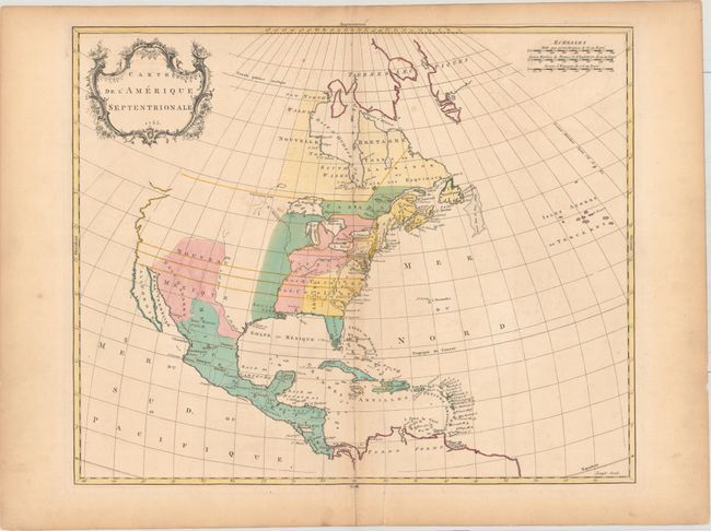
Auction 155, Lot 80
Subject: North America
Palairet, Jean
Carte de l'Amerique Septentrionale, 1755
Size: 22.9 x 18.8 inches (58.2 x 47.8 cm)
Estimate: $800 - $1,000
Rare British Map of North America with French Text
Sold for: $300
Closed on 11/18/2015
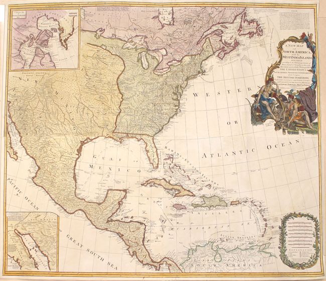
Auction 155, Lot 84
Subject: North America
Laurie & Whittle
A New Map of North America; with the West India Islands. Divided According to the Preliminary Articles of Peace, Signed at Versailles, 20, Jan. 1783, 1794
Size: 45.7 x 39.5 inches (116.1 x 100.3 cm)
Estimate: $2,400 - $3,000
Laurie & Whittle's Large-Scale Map of North America
Sold for: $1,800
Closed on 11/18/2015
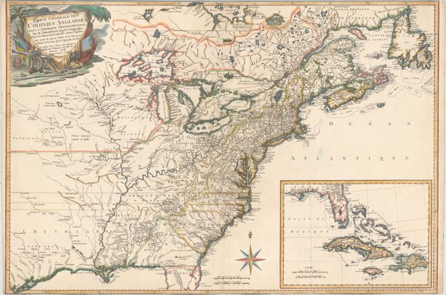
Auction 155, Lot 95
Subject: Colonial North America & Caribbean
Phelipeaux/Brion de la Tour
Carte Generale des Colonies Angloises, dans l'Amerique Septentrionale. Par M. Phelippeaux…, 1778
Size: 30 x 20.5 inches (76.2 x 52.1 cm)
Estimate: $3,750 - $4,500
Rare Separately-Issued Map of the Theater of the American Revolution
Unsold
Closed on 11/18/2015
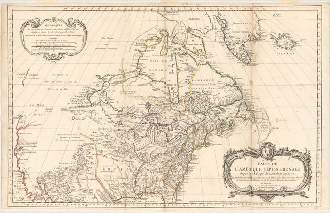
Auction 155, Lot 109
Subject: Colonial United States & Canada
Bellin, Jacques Nicolas
Carte de l'Amerique Septentrionale Depuis le 28 Degre de Latitude Jusqu'au 72, 1755
Size: 34 x 22 inches (86.4 x 55.9 cm)
Estimate: $1,500 - $1,800
NO RESERVE - Bellin's Important, Large Format Map of North America
Unsold
Closed on 11/18/2015
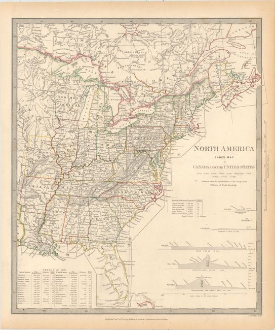
Auction 155, Lot 113
Subject: Canada & United States
SDUK Society for the Diffusion of Useful Knowledge
[Lot of 15 - North America], 1832-34
Size: See Description
Estimate: $1,300 - $1,600
Matching Set of North America SDUK Maps
Sold for: $650
Closed on 11/18/2015
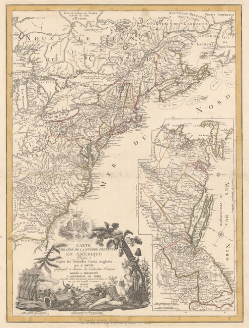
Auction 155, Lot 117
Subject: Colonial Eastern United States & Canada
Denis, Louis
Carte du Theatre de la Guerre Presente en Amerique Dressee d'Apres les Nouvelles Cartes Anglaises..., 1779
Size: 19.8 x 26.3 inches (50.3 x 66.8 cm)
Estimate: $5,500 - $6,500
Scarce American Revolutionary War Map
Unsold
Closed on 11/18/2015
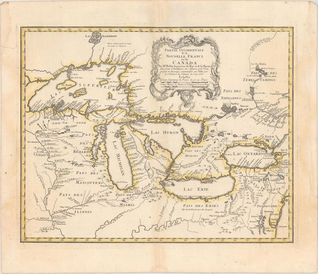
Auction 155, Lot 127
Subject: Colonial Great Lakes
Bellin/Homann Heirs
Partie Occidentale de la Nouvelle France ou du Canada, 1755
Size: 21.3 x 16.8 inches (54.1 x 42.7 cm)
Estimate: $1,400 - $1,700
Influential Map of the Great Lakes
Sold for: $1,500
Closed on 11/18/2015
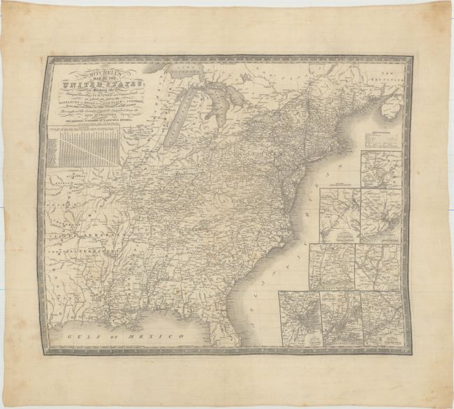
Auction 155, Lot 142
Subject: Eastern United States
Mitchell, Samuel Augustus
[Fabric Map] Mitchell's Map of the United States; Showing the Principal Travelling, Turnpike and Common Roads; on Which Are Given the Distances in Miles from One Place to Another..., 1836
Size: 23.6 x 19.1 inches (59.9 x 48.5 cm)
Estimate: $1,000 - $1,500
The Only Mitchell Map to be Printed on Silk
Sold for: $500
Closed on 11/18/2015
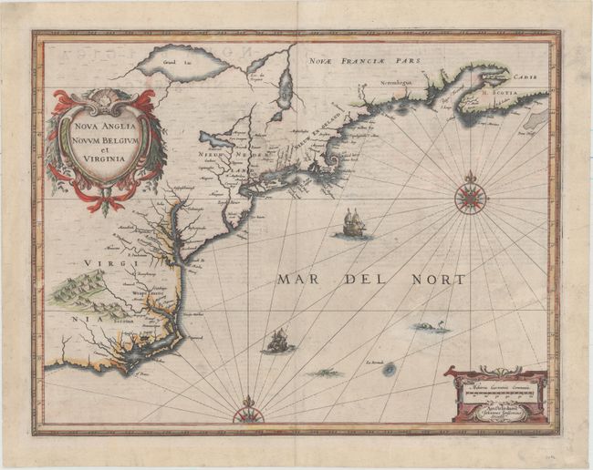
Auction 155, Lot 151
Subject: Colonial New England & Mid-Atlantic
Blaeu, Willem
Nova Belgica et Anglia Nova, 1635
Size: 19.6 x 15.2 inches (49.8 x 38.6 cm)
Estimate: $3,250 - $4,000
Important Map of Colonial New England and the Mid-Atlantic - Rare Example with Blank Verso
Sold for: $2,500
Closed on 11/18/2015
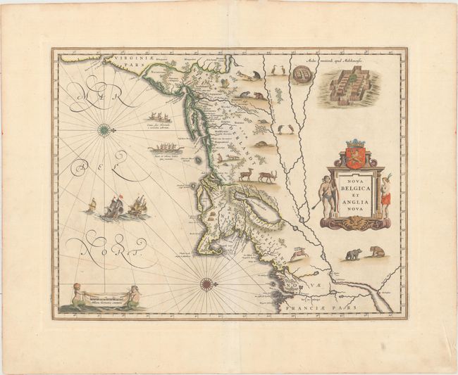
Auction 155, Lot 152
Subject: Colonial New England & Mid-Atlantic
Jansson, Jan
Nova Anglia Novum Belgium et Virginia, 1637
Size: 19.8 x 15.3 inches (50.3 x 38.9 cm)
Estimate: $1,600 - $1,900
Jansson's Influential Map of the East Coast
Sold for: $1,100
Closed on 11/18/2015
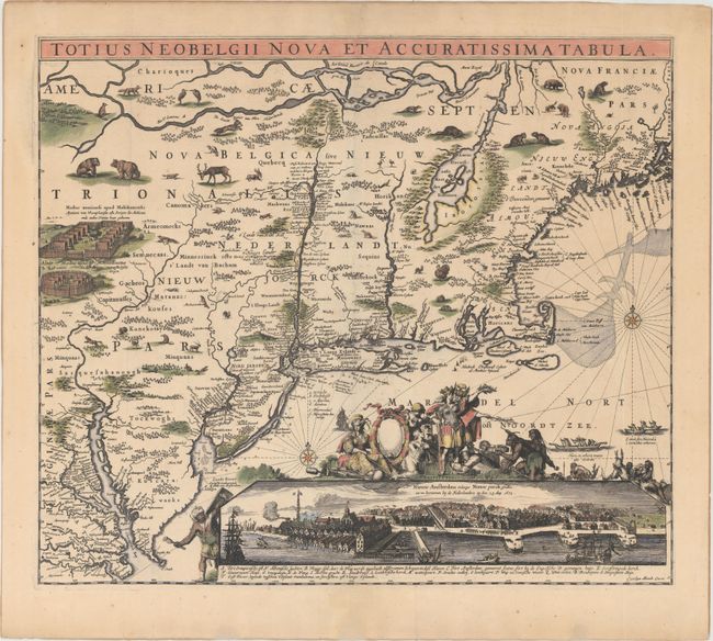
Auction 155, Lot 154
Subject: Colonial New England & Mid-Atlantic
Allard, Carel
Totius Neobelgii Nova et Accuratissima Tabula, 1680
Size: 21.3 x 18.3 inches (54.1 x 46.5 cm)
Estimate: $10,000 - $12,000
Rare Map of New England with Famous "Restitutio" View of New York City
Sold for: $7,500
Closed on 11/18/2015
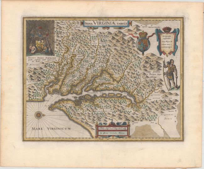
Auction 155, Lot 166
Subject: Colonial Mid-Atlantic United States
Hondius/Blaeu
Nova Virginiae Tabula, 1643
Size: 18.9 x 14.8 inches (48 x 37.6 cm)
Estimate: $2,750 - $3,500
One of the Most Important 17th Century Maps of the Chesapeake Bay
Unsold
Closed on 11/18/2015
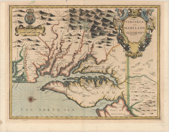
Auction 155, Lot 168
Subject: Colonial Mid-Atlantic United States
Speed/Lamb
A Map of Virginia and Maryland, 1676
Size: 19.4 x 14.8 inches (49.3 x 37.6 cm)
Estimate: $5,000 - $6,000
The First Printed Map to Draw Upon the Legendary Herrman Map of the Chesapeake Bay
Sold for: $4,250
Closed on 11/18/2015
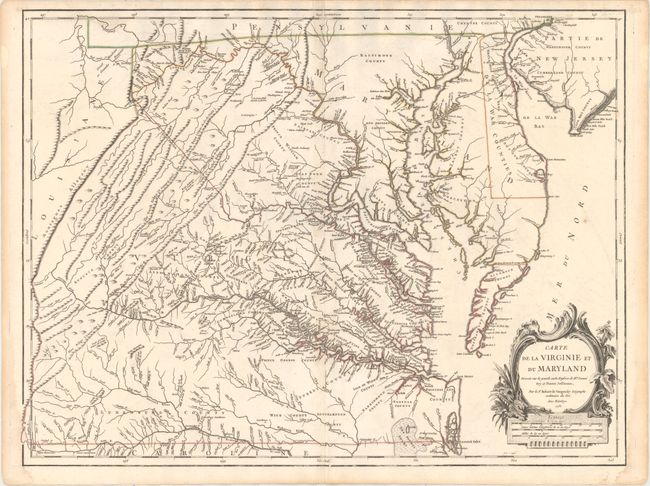
Auction 155, Lot 170
Subject: Colonial Mid-Atlantic United States
Robert de Vaugondy, Didier
Carte de la Virginie et du Maryland Dressee sur la Grande Carte Angloise de Mrs. Josue Fry et Pierre Jefferson..., 1755
Size: 25.4 x 19.1 inches (64.5 x 48.5 cm)
Estimate: $3,000 - $4,000
First State of Robert de Vaugondy's Essential Map of Virginia and Maryland
Unsold
Closed on 11/18/2015
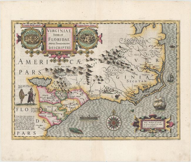
Auction 155, Lot 181
Subject: Colonial Southeast United States
Hondius, Jodocus
Virginiae Item et Floridae Americae Provinciarum, Nova Descriptio, 1607
Size: 19.1 x 13.5 inches (48.5 x 34.3 cm)
Estimate: $2,400 - $3,000
A Seminal Map of the Southeast and Early American Cartography
Sold for: $1,800
Closed on 11/18/2015
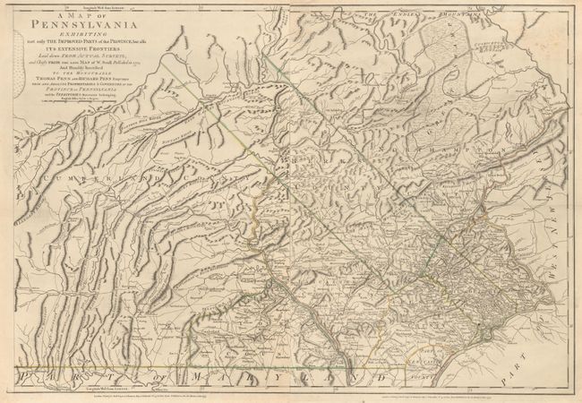
Auction 155, Lot 293
Subject: Pennsylvania
Sayer & Bennett
[On 2 Sheets] A Map of Pennsylvania Exhibiting Not Only the Improved Parts of that Province, but Also Its Extensive Frontiers…, 1775
Size: 19.7 x 26.8 inches (50 x 68.1 cm)
Estimate: $1,200 - $1,400
English Revision of William Scull’s Map of Pennsylvania
Sold for: $600
Closed on 11/18/2015
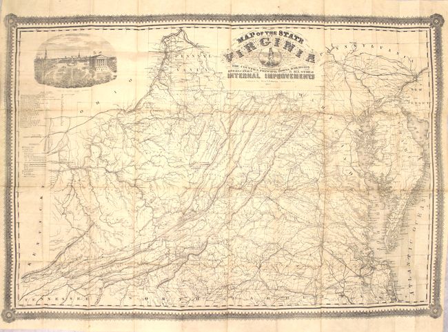
Auction 155, Lot 309
Subject: Virginia
West & Johnston
Map of the State of Virginia Containing the Counties, Principal Towns, Railroads, Rivers, Canals & all Other Internal Improvements, 1862
Size: 37 x 25.5 inches (94 x 64.8 cm)
Estimate: $9,500 - $12,000
Rare Civil War Map Based on Bucholtz Map of Virginia
Sold for: $6,500
Closed on 11/18/2015
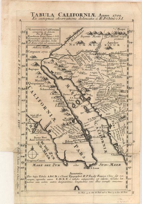
Auction 155, Lot 323
Subject: Southwestern United States & Mexico
Kino, Eusebio Francisco, SJ
Tabula Californiae, Anno 1702. Ex Autoptica Observatione Delineata a R.P. Chino e S.I., 1702
Size: 8.7 x 13.4 inches (22.1 x 34 cm)
Estimate: $1,600 - $2,000
NO RESERVE - Kino's Scarce Second Map of Lower California
Unsold
Closed on 11/18/2015
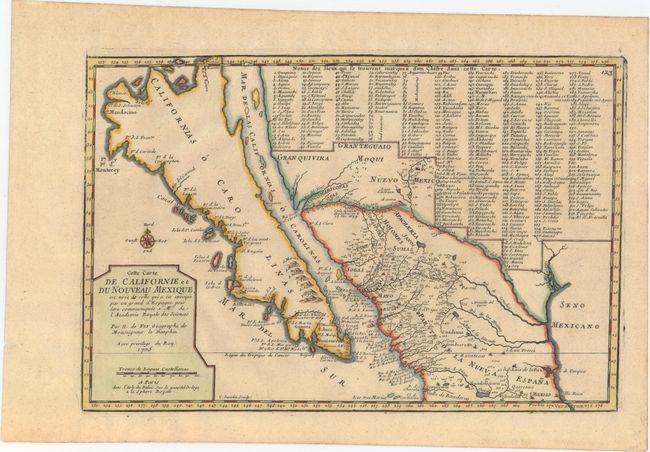
Auction 155, Lot 324
Subject: Southwestern United States & Mexico, California
Fer, Nicolas de
Cette Carte de Californie et du Nouveau Mexique, est Tiree de Celle qui a ete Envoyee par un Grand d'Espagne..., 1705
Size: 13.4 x 8.9 inches (34 x 22.6 cm)
Estimate: $1,200 - $1,500
De Fer's Important Map of the Island of California
Sold for: $900
Closed on 11/18/2015
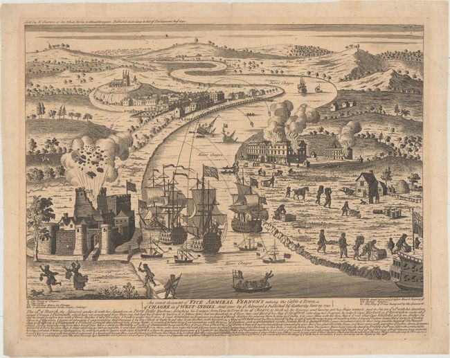
Auction 155, Lot 340
Subject: Chagres, Panama
Overton, Henry
An Exact Account of Vice Admiral Vernon's Taking the Castle & Town of Chagre in ye West-Indies, Sent Over by ye Admiral..., 1740
Size: 18.9 x 13.1 inches (48 x 33.3 cm)
Estimate: $2,000 - $2,300
Scarce View of Vernon's Capture of Fort San Lorenzo
Sold for: $1,500
Closed on 11/18/2015
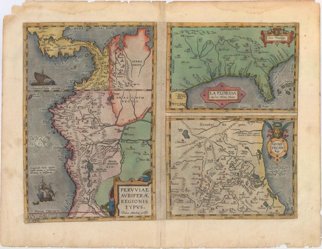
Auction 155, Lot 341
Subject: Gulf of Mexico, Florida & Peru
Ortelius, Abraham
Peruviae Auriferae Regionis Typus [on sheet with] La Florida [and] Guastecan, 1584
Size: 18.1 x 13.1 inches (46 x 33.3 cm)
Estimate: $1,300 - $1,600
The First Printed Map of the Southern United States
Sold for: $760
Closed on 11/18/2015
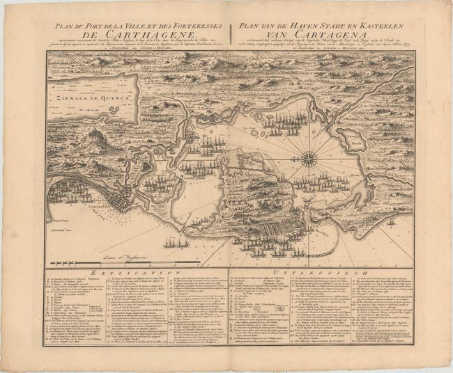
Auction 155, Lot 377
Subject: Cartagena, Colombia
Covens & Mortier
Plan du Port de la Ville, et des Forteresses de Carthagene... / Plan van de Haven, Stadt en Kasteelen van Cartagena..., 1741
Size: 22.4 x 17.8 inches (56.9 x 45.2 cm)
Estimate: $800 - $1,000
Scarce Plan of English Siege of Cartagena During War of Jenkins' Ear
Sold for: $550
Closed on 11/18/2015
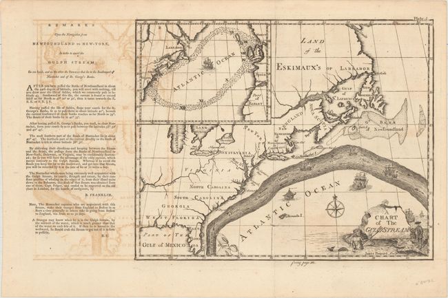
Auction 155, Lot 406
Subject: North Atlantic
Franklin, Benjamin
A Chart of the Gulf Stream [with] Remarks Upon the Navigation from Newfoundland to New York, in Order to Avoid the Gulf Stream, 1786
Size: 10.1 x 8.2 inches (25.7 x 20.8 cm)
Estimate: $5,000 - $6,000
Benjamin Franklin's Groundbreaking Chart of the Gulf Stream
Sold for: $4,500
Closed on 11/18/2015
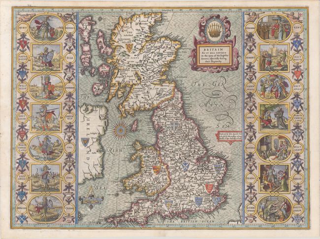
Auction 155, Lot 415
Subject: Britain
Speed, John
Britain as It Was Devided in the Tyme of the Englishe Saxons Especially During Their Heptarchy, 1616
Size: 20.2 x 15.1 inches (51.3 x 38.4 cm)
Estimate: $4,000 - $5,000
Early Example of Speed's "Heptarchy" Map Depicting the Saxon Kingdoms
Sold for: $3,750
Closed on 11/18/2015
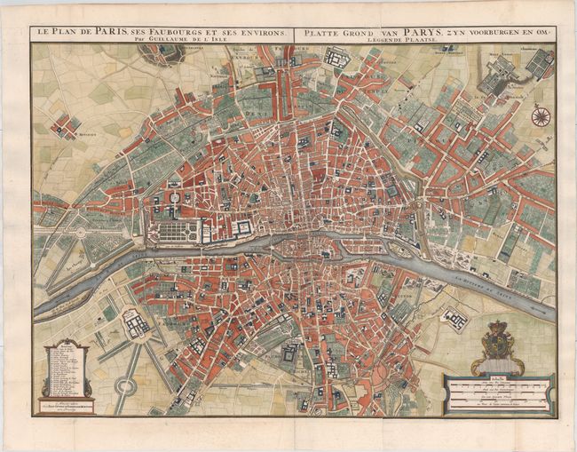
Auction 155, Lot 479
Subject: Paris, France
Delisle/Covens & Mortier
Le Plan de Paris, ses Faubourgs et ses Environs / Platte Grond van Parys, zyn Voorburgen en Omleggende Plaatse, 1730
Size: 29.7 x 22.3 inches (75.4 x 56.6 cm)
Estimate: $2,000 - $2,300
Stunning Oversized Plan of Paris
Sold for: $3,250
Closed on 11/18/2015
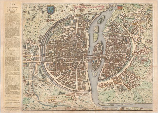
Auction 155, Lot 480
Subject: Paris, France
Dheulland, Guillaume
Ville Cite et Universite de Paris, 1766
Size: 31.8 x 26.1 inches (80.8 x 66.3 cm)
Estimate: $1,400 - $1,800
Rare Plan of Paris
Sold for: $900
Closed on 11/18/2015
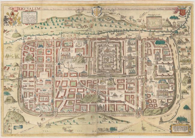
Auction 155, Lot 583
Subject: Jerusalem, Holy Land
Adrichom, Christian van
Ierusalem I., et Suburbia eius, Sicut Tempore Christi Floruit, cum Locis, in Quibus Christus Passus est…, 1584
Size: 29.6 x 20.2 inches (75.2 x 51.3 cm)
Estimate: $2,000 - $2,400
First Edition of Adrichom's Influential Bird's-Eye Plan of Jerusalem
Sold for: $1,500
Closed on 11/18/2015
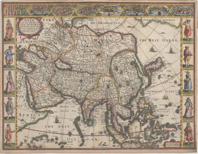
Auction 155, Lot 594
Subject: Asia
Speed, John
Asia with the Islands Adioyning Described, the Atire of the People, & Townes of Importance, All of Them Newly Augmented..., 1626
Size: 19.2 x 15.5 inches (48.8 x 39.4 cm)
Estimate: $3,250 - $4,000
Early Example of the First English Printed Map of Asia
Sold for: $2,170
Closed on 11/18/2015
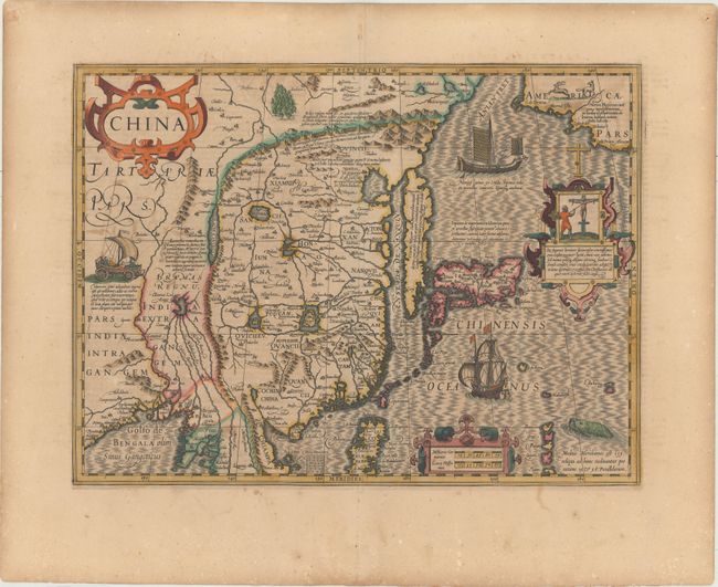
Auction 155, Lot 615
Subject: China, Korea & Japan
Mercator/Hondius
China, 1619
Size: 18.1 x 13.6 inches (46 x 34.5 cm)
Estimate: $3,000 - $3,750
Hondius' Map of China, Korea, and Japan
Sold for: $2,000
Closed on 11/18/2015
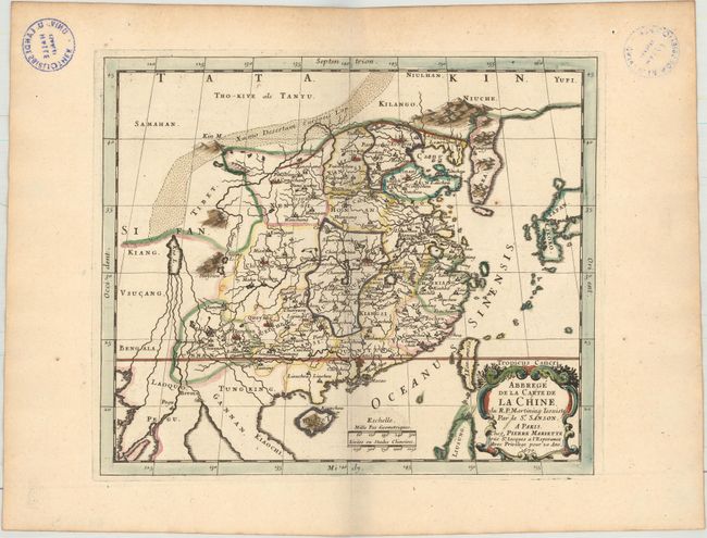
Auction 155, Lot 616
Subject: China & Korea
Sanson/Mariette
[Lot of 3] Abbrege de la Carte de la Chine. Du R.P. Martinius Iesuiste [and] ...du R.P. Bouyn Iesuiste [and] ...du R.P. Michel Ruggiery Iesuiste, 1670
Size: 9.3 x 7.9 inches (23.6 x 20.1 cm)
Estimate: $5,500 - $6,500
Scarce Set of Maps Showing Three Different Jesuit Missionary Depictions of China
Sold for: $6,500
Closed on 11/18/2015
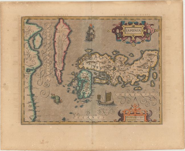
Auction 155, Lot 618
Subject: Japan & Korea
Mercator/Hondius
Iaponia, 1619
Size: 17.6 x 13.5 inches (44.7 x 34.3 cm)
Estimate: $1,400 - $1,700
Hondius' Richly Ornamented Map of Japan in Full Original Color
Sold for: $1,000
Closed on 11/18/2015
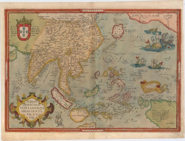
Auction 155, Lot 628
Subject: Southeast Asia
Ortelius, Abraham
Indiae Orientalis, Insularumque Adiacientium Typus, 1572
Size: 19.7 x 13.8 inches (50 x 35.1 cm)
Estimate: $3,000 - $3,750
Ortelius' Important Map of Southeast Asia
Sold for: $2,000
Closed on 11/18/2015
Auction 155, Lot 629
Subject: Southeast Asia
Blaeu, Willem
India quae Orientalis Dicitur, et Insulae Adiacentes, 1638
Size: 19.9 x 16.3 inches (50.5 x 41.4 cm)
Estimate: $1,600 - $1,900
The First Popular Map to Show European Discoveries in Australia
Sold for: $1,200
Closed on 11/18/2015
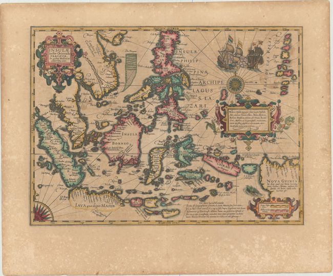
Auction 155, Lot 634
Subject: East Indies - Indonesia
Mercator/Hondius
Insulae Indiae Orientalis Praecipuae, in Quibus Moluccae Celeberrimae Sunt, 1619
Size: 18.9 x 13.6 inches (48 x 34.5 cm)
Estimate: $2,200 - $2,500
Hondius' Decorative Map of the Spice Islands in Full Original Color
Sold for: $1,500
Closed on 11/18/2015
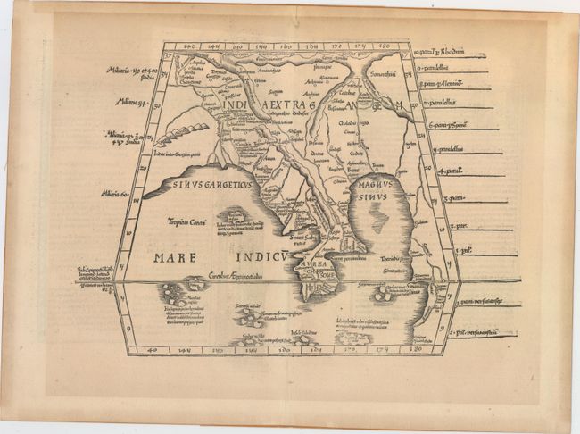
Auction 155, Lot 655
Subject: Southern Asia
Ptolemy/Fries
[Title on Verso] Tabula XI Asiae, 1535
Size: 16.1 x 11.3 inches (40.9 x 28.7 cm)
Estimate: $750 - $900
One of the Earliest Obtainable Maps of Southern Asia
Unsold
Closed on 11/18/2015
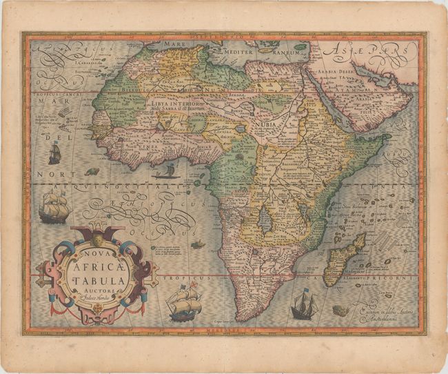
Auction 155, Lot 665
Subject: Africa
Hondius, Jodocus
Nova Africae Tabula, 1611
Size: 19.6 x 14.7 inches (49.8 x 37.3 cm)
Estimate: $1,500 - $1,800
Full Original Color
Unsold
Closed on 11/18/2015
63 lots
Page 1 of 2