Showing Featured Lots(remove filter)
Showing results for:Auction 152
Catalog Archive
72 lots
Page 1 of 2
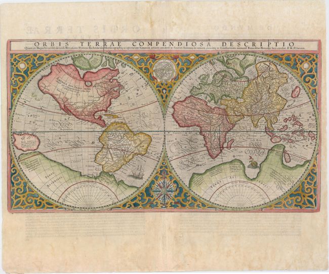
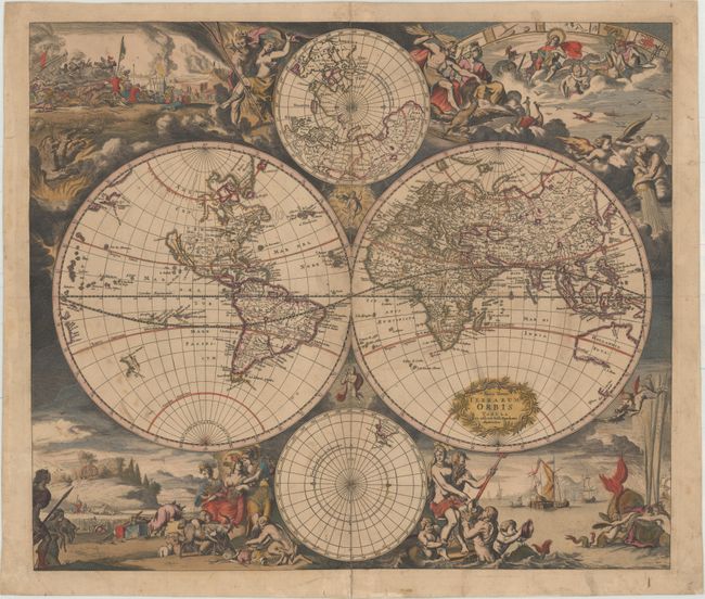
Auction 152, Lot 8
Subject: World
Mercator, Rumold
Orbis Terrae Compendiosa Descriptio…, 1587
Size: 20.6 x 11.4 inches (52.3 x 29 cm)
Estimate: $4,000 - $5,000
Mercator's Double-Hemisphere World Map
Sold for: $3,500
Closed on 2/18/2015
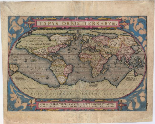
Auction 152, Lot 9
Subject: World
Ortelius, Abraham
Typus Orbis Terrarum, 1598
Size: 19.1 x 13 inches (48.5 x 33 cm)
Estimate: $7,000 - $9,000
Ortelius' Extremely Rare 2nd Plate from Dutch Edition
Sold for: $4,000
Closed on 2/18/2015
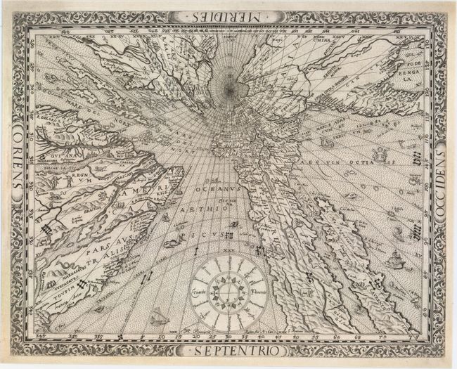
Auction 152, Lot 11
Subject: World
Ritter, Franz
[Untitled - World], 1640
Size: 14.3 x 11.3 inches (36.3 x 28.7 cm)
Estimate: $12,000 - $14,000
Ritter's Fascinating Sundial World Map
Sold for: $12,500
Closed on 2/18/2015
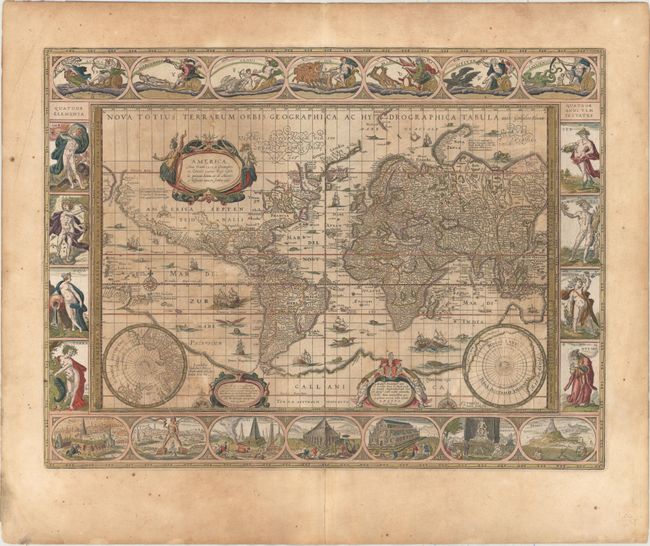
Auction 152, Lot 12
Subject: World
Blaeu, Willem
Nova Totius Terrarum Orbis Geographica ac Hydrographica Tabula, 1640
Size: 21.4 x 16 inches (54.4 x 40.6 cm)
Estimate: $11,000 - $13,000
Blaeu's Magnificent Carte-a-Figures World Map
Unsold
Closed on 2/18/2015
Auction 152, Lot 15
Subject: World
Danckerts, Justus
Nova Totius Terrarum Orbis Tabula, 1680
Size: 21.7 x 18.8 inches (55.1 x 47.8 cm)
Estimate: $4,000 - $4,750
Danckerts' Decorative Double-Hemisphere Map
Unsold
Closed on 2/18/2015
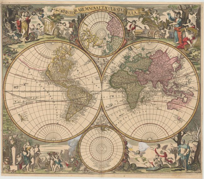
Auction 152, Lot 17
Subject: World
Valck, Gerard and Leonard
Orbis Terrarum Nova et Accurata Tabula, 1700
Size: 22.4 x 19.1 inches (56.9 x 48.5 cm)
Estimate: $5,000 - $6,500
Baroque-Style Double-Hemisphere Map Depicting the Four Seasons
Unsold
Closed on 2/18/2015
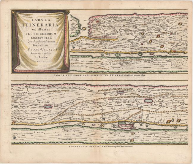
Auction 152, Lot 32
Subject: Ancient World
Jansson, Jan
[On 4 Sheets] Tabula Itineraria ex Illustri Peutingerorum Bibliotheca..., 1662
Size: 20.1 x 15.5 inches (51.1 x 39.4 cm)
Estimate: $3,500 - $4,250
Jansson's Famous Peutinger Table
Sold for: $2,100
Closed on 2/18/2015
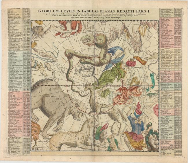
Auction 152, Lot 42
Subject: Celestial
Doppelmayr/Homann
[Lot of 6] Globi Coelestis in Tabulas Planas Redacti Pars I... [and] ... Pars II... [and] ... Pars III... [and] ... Pars IV... [and] ... Pars V... [and] ... Pars VI..., 1730
Size: 23 x 19.4 inches (58.4 x 49.3 cm)
Estimate: $3,500 - $4,500
Complete Matching Set of Doppelmayr's Celestial Charts on a Gnomonic Projection
Sold for: $3,750
Closed on 2/18/2015
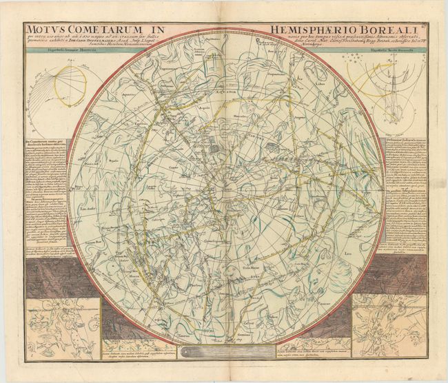
Auction 152, Lot 43
Subject: Celestial
Doppelmayr/Homann
[Lot of 2] Motus Cometarum in Hemisphaerio Boreali... [and] Motus Cometarum in Hemisphaerio Australi..., 1742
Size: 22.7 x 18.9 inches (57.7 x 48 cm)
Estimate: $1,400 - $1,700
Matching Pair of Charts Showing the Paths of the Comets
Sold for: $1,000
Closed on 2/18/2015
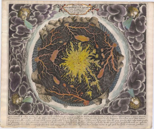
Auction 152, Lot 54
Subject: Cartographic Miscellany, Earth
Kircher, Athanasius
Systema Ideale Quo Exprimitur, Aquarum per Canales Hydragogos Subterraneos ex Mari et in Montium Hydrophylacia Protrusio, Aquarumq. Subterrestrium per Pyragogos Canales Concoctus, 1682
Size: 16.3 x 13.1 inches (41.4 x 33.3 cm)
Estimate: $1,600 - $1,800
Fascinating Cross-Section of the Earth
Sold for: $1,200
Closed on 2/18/2015
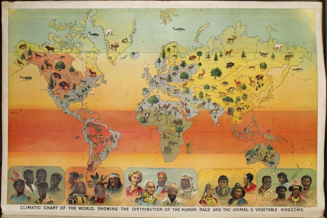
Auction 152, Lot 56
Subject: Cartographic Miscellany
Yaggy, Levi W.
Yaggy's Geographical Portfolio, 1893
Size: 39.6 x 26.5 inches (100.6 x 67.3 cm)
Estimate: $2,000 - $3,000
A Rare Piece of Americana in Stunning Multi-Color Lithography
Sold for: $6,500
Closed on 2/18/2015
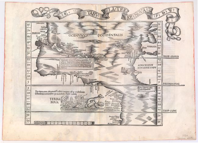
Auction 152, Lot 57
Subject: Western Hemisphere - America, Atlantic Ocean
Waldseemuller/Fries
E. Tabula Terre Nova F.D.W., 1522
Size: 17.1 x 12.8 inches (43.4 x 32.5 cm)
Estimate: $19,500 - $21,000
Rare First Issue of the Waldseemuller/Fries "Admiral's Map"
Unsold
Closed on 2/18/2015
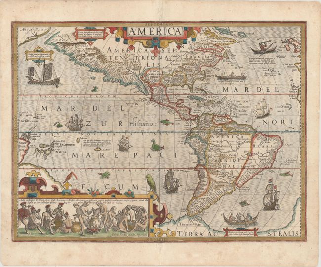
Auction 152, Lot 58
Subject: Western Hemisphere - America
Hondius, Jodocus
America, 1623
Size: 19.9 x 14.9 inches (50.5 x 37.8 cm)
Estimate: $3,750 - $4,500
Hondius' Important Map of the Americas
Sold for: $2,750
Closed on 2/18/2015
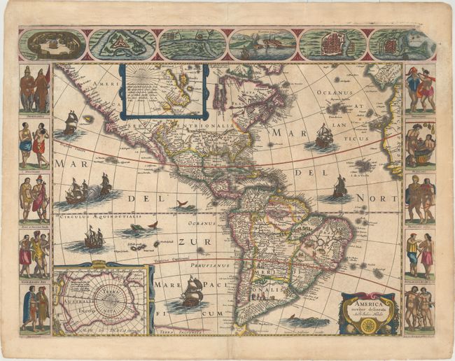
Auction 152, Lot 60
Subject: Western Hemisphere - America
Hondius/Jansson
America Noviter Delineata, 1632
Size: 21.8 x 16.3 inches (55.4 x 41.4 cm)
Estimate: $10,000 - $12,000
Jansson's Rare Carte-a-Figures Map of the Americas
Unsold
Closed on 2/18/2015
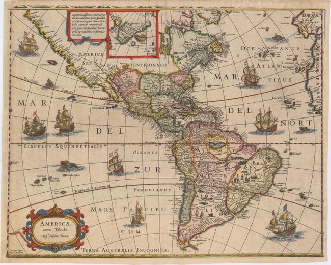
Auction 152, Lot 61
Subject: Western Hemisphere - America
Blaeu, Willem
Americae Nova Tabula, 1633
Size: 18 x 14.3 inches (45.7 x 36.3 cm)
Estimate: $2,400 - $3,000
Rare Edition of Blaeu's Map of the Americas
Sold for: $2,300
Closed on 2/18/2015
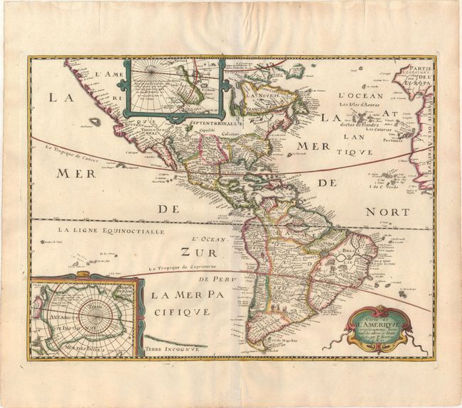
Auction 152, Lot 63
Subject: Western Hemisphere - America
Bertius/Tavernier
Carte de l'Amerique Corrigee et augmentee; dessus toutes les aultres cy devant faictes par P. Bertius, 1662
Size: 14.4 x 10.8 inches (36.6 x 27.4 cm)
Estimate: $1,600 - $1,900
Scarce Derivative of Hondius' Influential Map
Unsold
Closed on 2/18/2015

Auction 152, Lot 69
Subject: Western Hemisphere - America, Pacific & Atlantic Oceans
Leth, Andries & Hendrik de
Carte Nouvelle de la Mer du Sud, Dressee par Ordre des Principaux Directeurs, & Tiree des Memoires les Plus Recens e des Relations des Navigateurs les Plus Modernes..., 1740
Size: 36.8 x 23.4 inches (93.5 x 59.4 cm)
Estimate: $11,000 - $13,000
De Leth's Extraordinary Map of the Americas and the Oceans
Sold for: $8,500
Closed on 2/18/2015
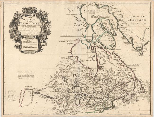
Auction 152, Lot 123
Subject: Colonial Northeastern United States & Canada, Great Lakes
Delisle, Guillaume
Carte du Canada ou de la Nouvelle France et des Decouvertes qui y ont ete faites..., 1703
Size: 25.7 x 19.7 inches (65.3 x 50 cm)
Estimate: $2,400 - $3,000
Delisle's Seminal Map of Canada and the Great Lakes
Sold for: $2,100
Closed on 2/18/2015
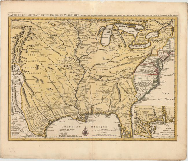
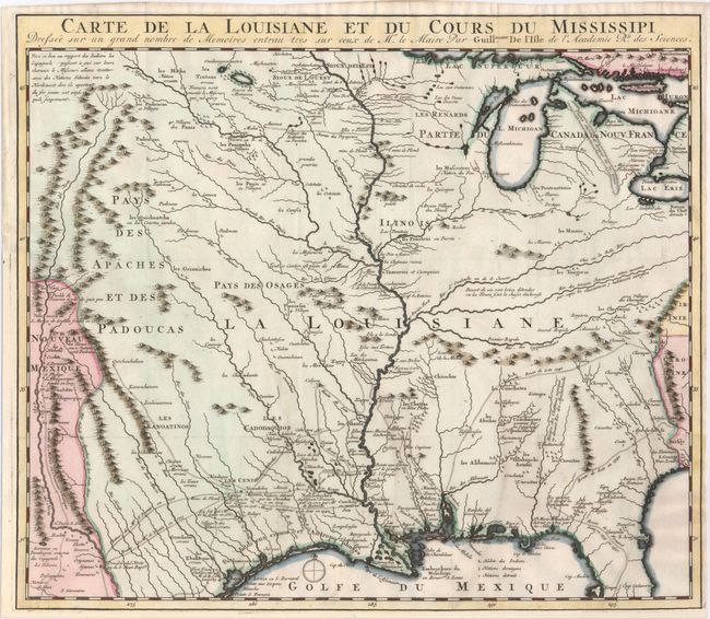
Auction 152, Lot 138
Subject: Colonial Eastern United States, Louisiana Territory
Delisle/Covens & Mortier
Carte de la Louisiane et du Cours du Mississipi Dressee sur un Grand Nombre de Memoires Entr'autres sur ceux de Mr. le Maire, 1730
Size: 23.6 x 17.3 inches (59.9 x 43.9 cm)
Estimate: $2,750 - $3,500
Delisle's Influential Map of the Louisiana Territory
Sold for: $1,800
Closed on 2/18/2015
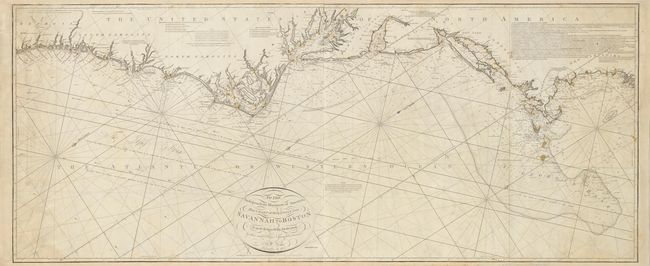
Auction 152, Lot 146
Subject: Eastern United States
Norie, John William
To the Independent Mariners of America, This Chart of their Coast from Savannah to Boston is most Respectfully Dedicated…, 1852
Size: 61 x 25.3 inches (154.9 x 64.3 cm)
Estimate: $2,000 - $2,300
Rare Blue-Back Chart of the East Coast
Sold for: $1,500
Closed on 2/18/2015
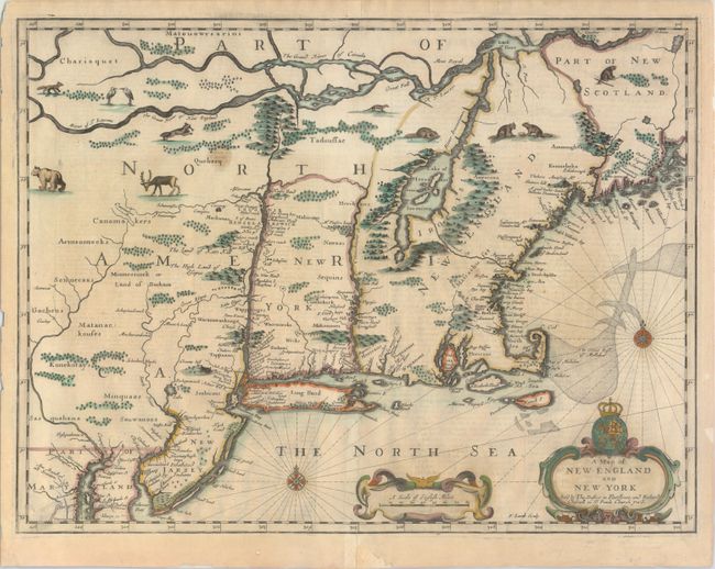
Auction 152, Lot 149
Subject: Colonial New England & New York
Speed/Lamb
A Map of New England and New York, 1676
Size: 19.7 x 15 inches (50 x 38.1 cm)
Estimate: $5,000 - $6,000
"Speed" Map of New England
Sold for: $3,500
Closed on 2/18/2015
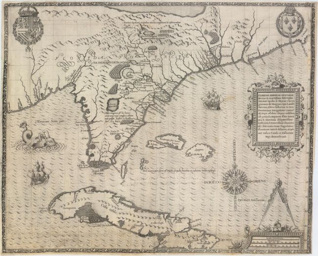
Auction 152, Lot 160
Subject: Colonial Southeast, Florida and Cuba
Bry, Theodore de
Floridae Americae Provinciae Recens & Exactissima Descriptio Auctore Iacobo le Moyne..., 1591
Size: 17.9 x 14.5 inches (45.5 x 36.8 cm)
Estimate: $11,000 - $15,000
De Bry's Influential Map of Colonial North America
Unsold
Closed on 2/18/2015
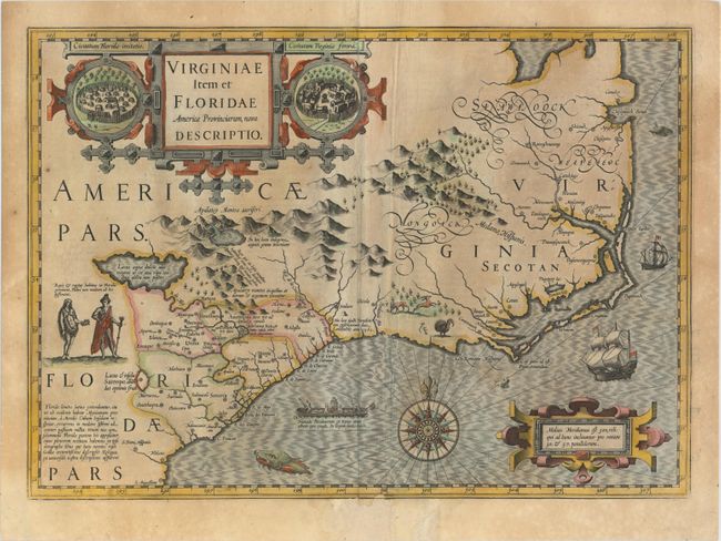
Auction 152, Lot 161
Subject: Colonial Southeast United States
Hondius, Jodocus
Virginiae Item et Floridae Americae Provinciarum, Nova Descriptio, 1623
Size: 19.2 x 13.6 inches (48.8 x 34.5 cm)
Estimate: $2,300 - $2,750
A Seminal Map of the Southeast and Early American Cartography
Sold for: $1,500
Closed on 2/18/2015
Auction 152, Lot 173
Subject: Colonial Central & Southern United States
Delisle, Guillaume
Carte de la Louisiane et du Cours du Mississipi Dressee sur un Grand Nombre de Memoires..., 1727
Size: 16.2 x 14 inches (41.1 x 35.6 cm)
Estimate: $2,000 - $2,300
Reduced-Size Edition of Delisle's Influential Map of the Louisiana Territory
Sold for: $1,000
Closed on 2/18/2015
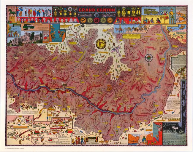
Auction 152, Lot 189
Subject: Grand Canyon, Arizona
Mora, Joseph Jacinto
Grand Canyon, 1959
Size: 18.1 x 14.1 inches (46 x 35.8 cm)
Estimate: $200 - $250
Reduced Version of Jo Mora's Splashy Map of the Grand Canyon
Sold for: $350
Closed on 2/18/2015
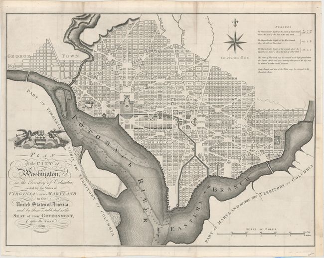
Auction 152, Lot 198
Subject: Washington, D.C.
Russell, John C.
Plan of the City of Washington, in the Territory of Columbia, Ceded by the States of Virginia and Maryland to the United States of America, and by Them Established as the Seat of Their Government, After the Year 1800, 1795
Size: 21 x 15.8 inches (53.3 x 40.1 cm)
Estimate: $3,000 - $3,750
Rare, Early Large Format Map of Washington D.C.
Sold for: $3,250
Closed on 2/18/2015
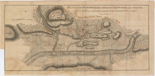
Auction 152, Lot 228
Subject: Colonial New York, Revolutionary War
Faden, William
Plan of the Position which the Army under Lt. Genl. Burgoine Took at Saratoga on the 10th of September 1777..., 1780
Size: 18.8 x 8.5 inches (47.8 x 21.6 cm)
Estimate: $1,500 - $1,800
Important Revolutionary War Map
Sold for: $750
Closed on 2/18/2015
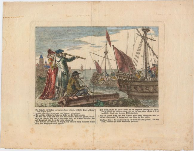
Auction 152, Lot 236
Subject: New York City, New York
Anon.
Die Sussigkeit des Friedens Wird Nur von Denen Verkannt, Welche die Plagen des Kriegs Nicht Erfahren Haben, 1790
Size: 10.1 x 6.7 inches (25.7 x 17 cm)
Estimate: $600 - $800
The Infamous British Prison Ships of the Revolutionary War
Sold for: $400
Closed on 2/18/2015
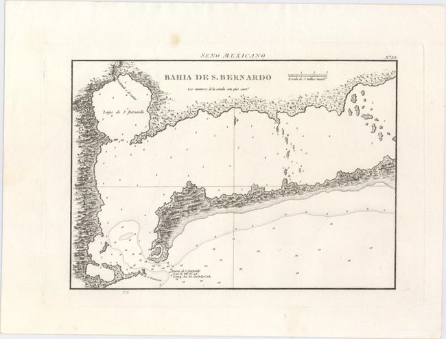
Auction 152, Lot 258
Subject: Matagorda Bay, Texas
Direccion de Hidrografia
Bahia de S. Bernardo, 1809
Size: 10.3 x 7.3 inches (26.2 x 18.5 cm)
Estimate: $800 - $1,000
First Engraved Map of Matagorda Bay
Sold for: $400
Closed on 2/18/2015
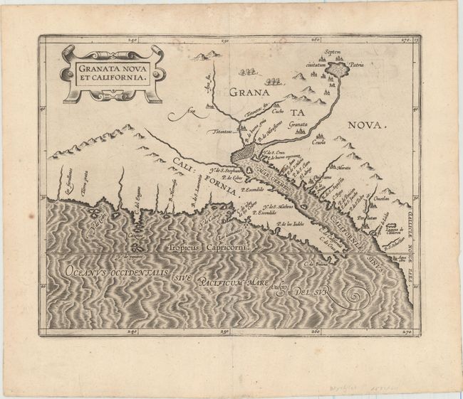
Auction 152, Lot 278
Subject: Southwestern United States & Mexico
Wytfliet, Cornelis
Granata Nova et California, 1597
Size: 11.4 x 9.1 inches (29 x 23.1 cm)
Estimate: $2,400 - $3,000
First Printed Map to Focus on California and the Southwest
Sold for: $2,000
Closed on 2/18/2015
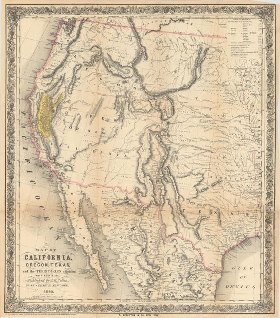
Auction 152, Lot 293
Subject: Western United States & Mexico
Colton, Joseph Hutchins
Map of California, Oregon, Texas, and the Territories Adjoining with Routes &c., 1849
Size: 18.1 x 20.8 inches (46 x 52.8 cm)
Estimate: $1,500 - $1,800
Colton's Rare Map Depicting the Gold Region of California
Sold for: $1,200
Closed on 2/18/2015
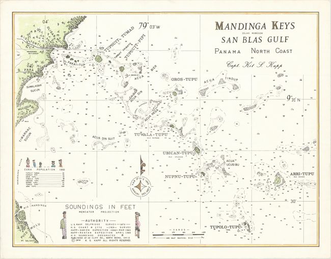
Auction 152, Lot 309
Subject: Northern Panama
Kapp, Kit S.
Mandinga Keys Islas Robeson San Blas Gulf Panama North Coast, 1970
Size: 25.4 x 19.6 inches (64.5 x 49.8 cm)
Estimate: $100 - $200
Map by Kit Kapp - All Proceeds Donated to IMCOS in Kapp's Honor
Sold for: $275
Closed on 2/18/2015
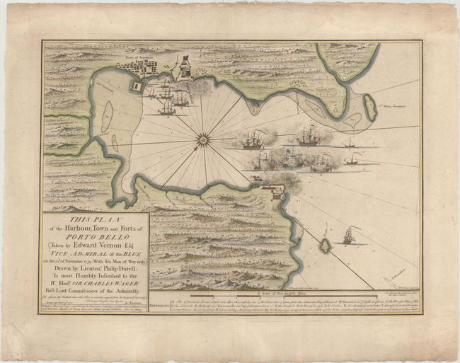
Auction 152, Lot 310
Subject: Portobelo, Panama
Durell, Philip
This Plan of the Harbour, Town and Forts of Porto Bello (Taken by Edward Vernon Esqr. Vice Admiral of the Blue on the 22d. of November 1739. With Six Men of War Only), 1740
Size: 23 x 16.4 inches (58.4 x 41.7 cm)
Estimate: $700 - $850
Rare Chart of the Battle of Portobello
Sold for: $500
Closed on 2/18/2015
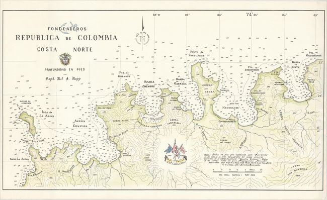
Auction 152, Lot 351
Subject: Northern Colombia
Kapp, Kit S.
Fondeaderos Republica de Colombia Costa Norte, 1970
Size: 33.2 x 18.7 inches (84.3 x 47.5 cm)
Estimate: $100 - $200
Map by Kit Kapp - All Proceeds Donated to IMCOS in Kapp's Honor
Sold for: $50
Closed on 2/18/2015
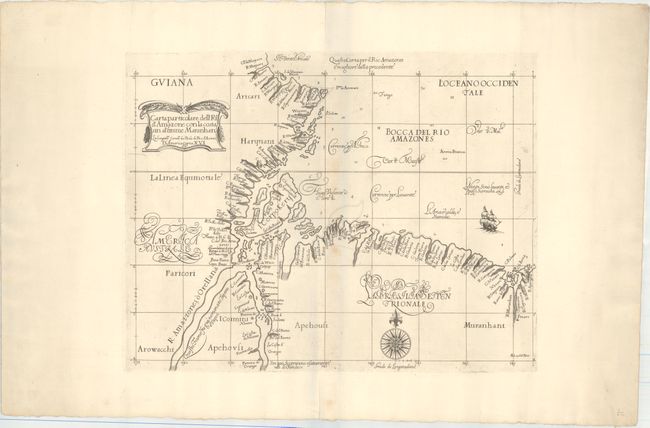
Auction 152, Lot 360
Subject: Brazil
Dudley, Robert (Sir)
Carte Particolare dell' Rio d'Amazone con la Costa sin al' Fiume Maranhan…, 1661
Size: 18.4 x 14.6 inches (46.7 x 37.1 cm)
Estimate: $1,600 - $1,900
Dudley's Rare Chart of the Mouth of the Amazon River
Sold for: $1,200
Closed on 2/18/2015
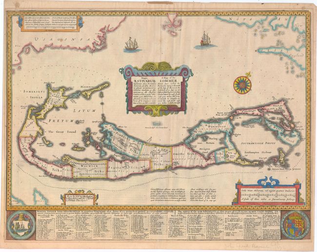
Auction 152, Lot 378
Subject: Bermuda
Speed, John
A Mapp of the Sommer Ilands… / Mappa Aestivarum Insularum…, 1676
Size: 20.8 x 15.8 inches (52.8 x 40.1 cm)
Estimate: $1,800 - $2,200
Speed's Foundation Map of Bermuda
Sold for: $1,300
Closed on 2/18/2015
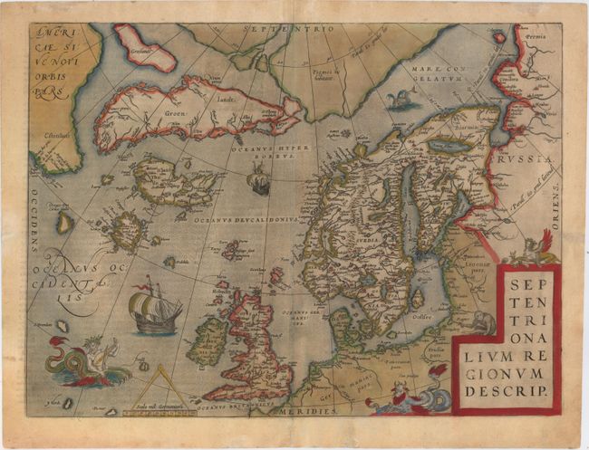
Auction 152, Lot 382
Subject: Arctic & Scandinavia
Ortelius, Abraham
Septentrionalium Regionum Descrip., 1588
Size: 19.3 x 14.2 inches (49 x 36.1 cm)
Estimate: $2,400 - $3,000
Ortelius' Map of the Arctic with Several Mythical Islands
Sold for: $1,300
Closed on 2/18/2015
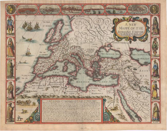
Auction 152, Lot 386
Subject: Europe
Speed, John
A New Mappe of the Romane Empire, 1626
Size: 19.9 x 15.4 inches (50.5 x 39.1 cm)
Estimate: $1,800 - $2,100
Speed's Carte-a-Figures Map of the Roman Empire
Sold for: $1,900
Closed on 2/18/2015
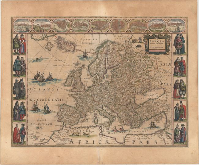
Auction 152, Lot 387
Subject: Europe
Blaeu, Willem
Europa Recens Descripta, 1644
Size: 21.9 x 16.2 inches (55.6 x 41.1 cm)
Estimate: $2,400 - $3,000
Blaeu's Carte-a-Figures Map of Europe
Unsold
Closed on 2/18/2015
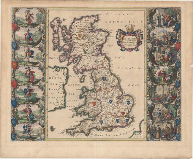
Auction 152, Lot 391
Subject: Britain
Blaeu, Johannes
Britannia Prout Divisa suit Temporibus Anglo-Saxonum, Praesertim Durante Illorum Heptarchia, 1645
Size: 20.8 x 16.3 inches (52.8 x 41.4 cm)
Estimate: $3,000 - $4,000
Decorative Map of Britain with Vignettes of Saxon History
Sold for: $2,200
Closed on 2/18/2015
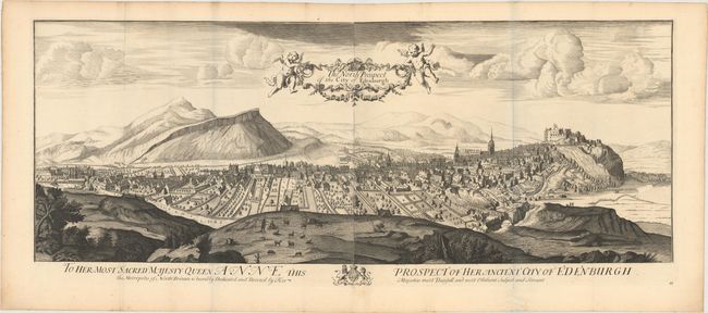
Auction 152, Lot 412
Subject: Edinburgh, Scotland
Slezer, John
The North Prospect of the City of Edenburgh, 1719
Size: 42.2 x 17.5 inches (107.2 x 44.5 cm)
Estimate: $2,300 - $2,750
Dramatic View of Edinburgh, Dedicated to Queen Anne
Sold for: $1,700
Closed on 2/18/2015
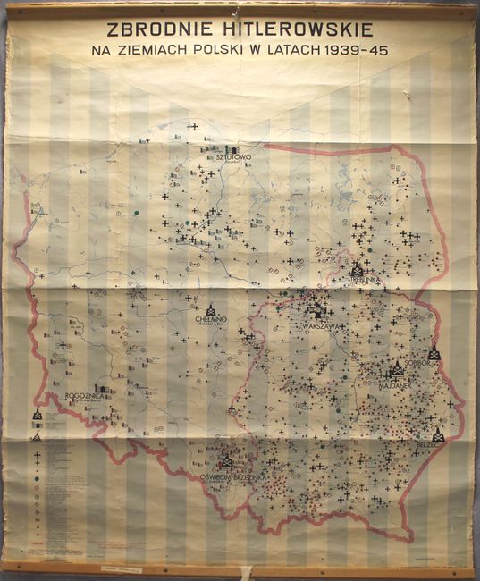
Auction 152, Lot 488
Subject: Poland
Zbrodnie Hitlerowskie na Ziemiach Polski w Latach 1939-45, 1962
Size: 46.3 x 57.5 inches (117.6 x 146.1 cm)
Estimate: $800 - $1,000
Wall-Sized Map Depicting the Sites of Nazi Crimes in Poland During WWII
Sold for: $1,500
Closed on 2/18/2015
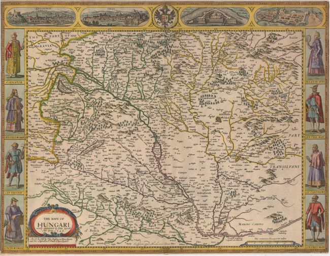
Auction 152, Lot 500
Subject: Hungary
Speed, John
The Mape of Hungari, 1626
Size: 20.3 x 15.5 inches (51.6 x 39.4 cm)
Estimate: $1,500 - $1,800
Speed's Carte-a-Figures Map of Hungary
Sold for: $900
Closed on 2/18/2015
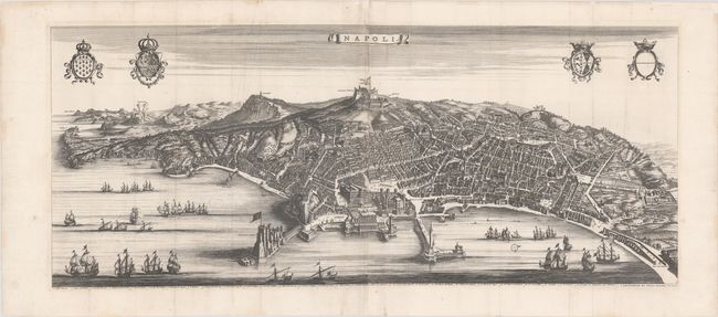
Auction 152, Lot 549
Subject: Naples, Italy
Blaeu/Mortier
Napoli, 1704
Size: 40.1 x 16.5 inches (101.9 x 41.9 cm)
Estimate: $2,750 - $3,500
A Rare and Stunning Panoramic View of Naples
Unsold
Closed on 2/18/2015
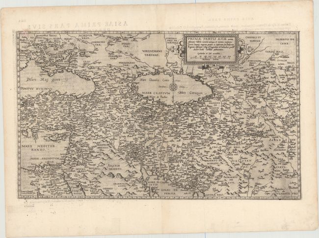
Auction 152, Lot 561
Subject: Eastern Mediterranean & Middle East
Jode, Gerard de
Primae Partis Asiae Acurata Delineatio Habens Nomina Antiqua et Recentia Continens..., 1593
Size: 19.9 x 11.8 inches (50.5 x 30 cm)
Estimate: $2,400 - $3,000
De Jode's Rare Map of the Middle East
Sold for: $1,800
Closed on 2/18/2015
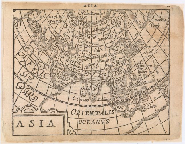
Auction 152, Lot 597
Subject: Asia
Heyns, Zacharias
Asia, 1598
Size: 6.9 x 5.5 inches (17.5 x 14 cm)
Estimate: $750 - $900
Scarce Map Published by Zacharias Heyns
Unsold
Closed on 2/18/2015
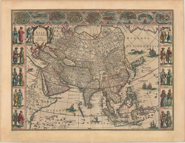
Auction 152, Lot 598
Subject: Asia
Blaeu, Willem
Asia Noviter Delineata, 1631
Size: 21.9 x 16.3 inches (55.6 x 41.4 cm)
Estimate: $4,750 - $6,000
Magnificent Carte-a-Figures Map of Asia
Sold for: $3,500
Closed on 2/18/2015
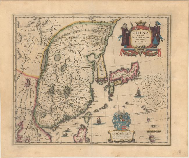
Auction 152, Lot 617
Subject: China, Korea & Japan
Blaeu, (Family)
China Veteribus Sinarum Regio Nunc Incolis Tame Dicta, 1635
Size: 19.6 x 16.2 inches (49.8 x 41.1 cm)
Estimate: $1,600 - $1,900
Blaeu's Map of China Featuring Fictitious Lakes and Rivers
Sold for: $1,500
Closed on 2/18/2015
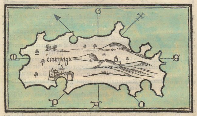
Auction 152, Lot 623
Subject: Japan
Bordone, Benedetto
Ciampagu [on verso] Iava Majjiore, 1528
Size: 5.8 x 3.4 inches (14.7 x 8.6 cm)
Estimate: $1,600 - $1,800
First Known Map Devoted to Japan
Sold for: $1,200
Closed on 2/18/2015
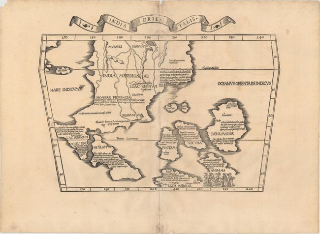
Auction 152, Lot 633
Subject: Southeast Asia
Ptolemy/Fries
India Orientalis, 1535
Size: 16.8 x 12.3 inches (42.7 x 31.2 cm)
Estimate: $2,400 - $3,000
First Printed Map to Focus on Indochina and the East Indies
Unsold
Closed on 2/18/2015
72 lots
Page 1 of 2