Showing Featured Lots(remove filter)
Showing results for:Auction 151
Catalog Archive
55 lots
Page 1 of 2

Auction 151, Lot 1
Subject: Title Pages - Portraits
Hondius
Gerardus Mercator … Iudocus Hondius …, 1623
Size: 17.8 x 15.3 inches (45.2 x 38.9 cm)
Estimate: $2,000 - $2,300
Famous Portraits of Mercator and Jodocus Hondius
Unsold
Closed on 11/19/2014
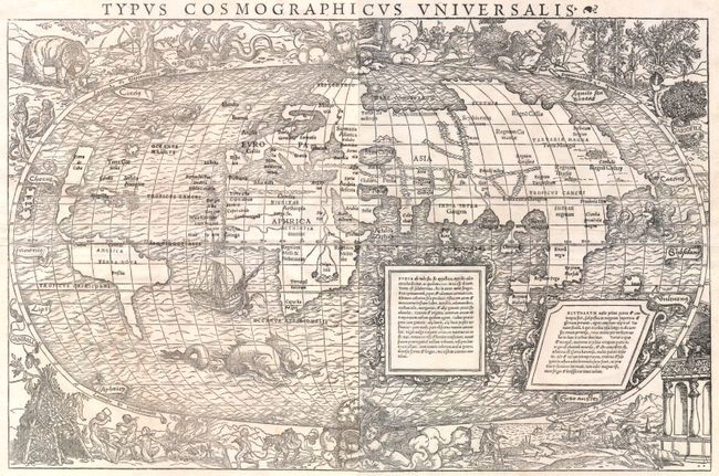
Auction 151, Lot 7
Subject: World
Munster, Sebastian
[On 2 Sheets] Typus Cosmographicus Universalis [with book] Novus Orbis Regionum ac Insularum Veteribus Incognitarum..., 1537
Size: 22.5 x 14.5 inches (57.2 x 36.8 cm)
Estimate: $30,000 - $35,000
One of the Most Sought-After Decorative Maps of the Early 16th Century
Sold for: $19,000
Closed on 11/19/2014
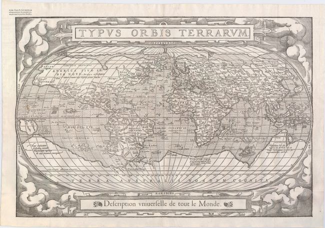
Auction 151, Lot 8
Subject: World
Belleforest, Francois
Typus Orbis Terrarum, 1575
Size: 19.5 x 13.2 inches (49.5 x 33.5 cm)
Estimate: $5,500 - $6,500
Scarce Woodcut Version of Ortelius’ World Map
Sold for: $3,000
Closed on 11/19/2014
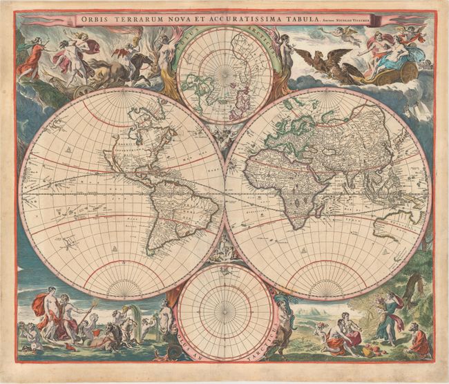
Auction 151, Lot 11
Subject: World
Visscher, Nicolas
Orbis Terrarum Nova et Accuratissima Tabula, 1658
Size: 22.1 x 18.4 inches (56.1 x 46.7 cm)
Estimate: $5,000 - $6,500
Visscher's Superb Double-Hemisphere World Map
Unsold
Closed on 11/19/2014
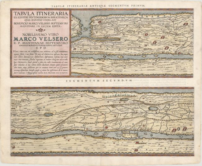
Auction 151, Lot 28
Subject: Ancient World
Ortelius, Abraham
[On 4 Sheets] Tabula Itineraria ex Illustri Peutingerorum Bibliotheca…Nobilissimo Viro Marco Velsero..., 1598
Size: 20.3 x 16.2 inches (51.6 x 41.1 cm)
Estimate: $7,000 - $8,500
Ortelius' Scarce Peutinger Table
Sold for: $5,000
Closed on 11/19/2014
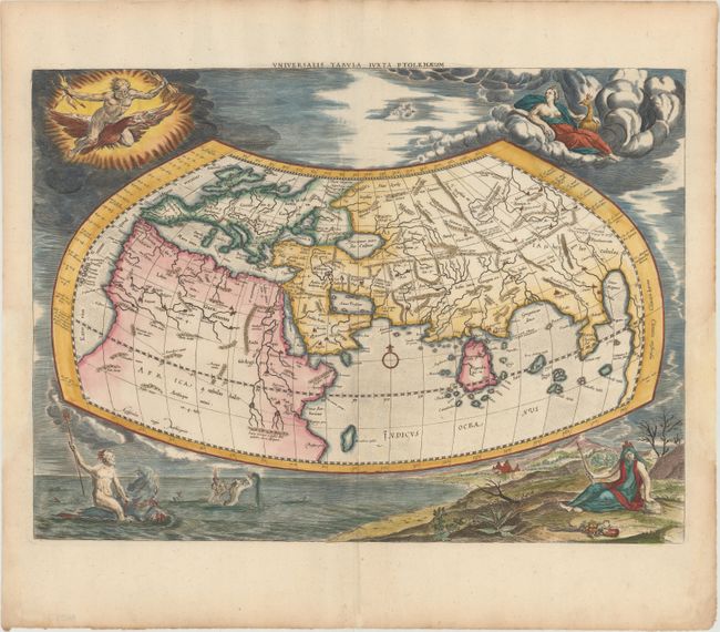
Auction 151, Lot 29
Subject: Ancient World
Ptolemy/Mercator
Universalis Tabula Iuxta Ptolemaeum, 1730
Size: 18.7 x 13.7 inches (47.5 x 34.8 cm)
Estimate: $2,400 - $3,000
Ancient Map of the World with Depictions of the Four Elements
Sold for: $1,600
Closed on 11/19/2014
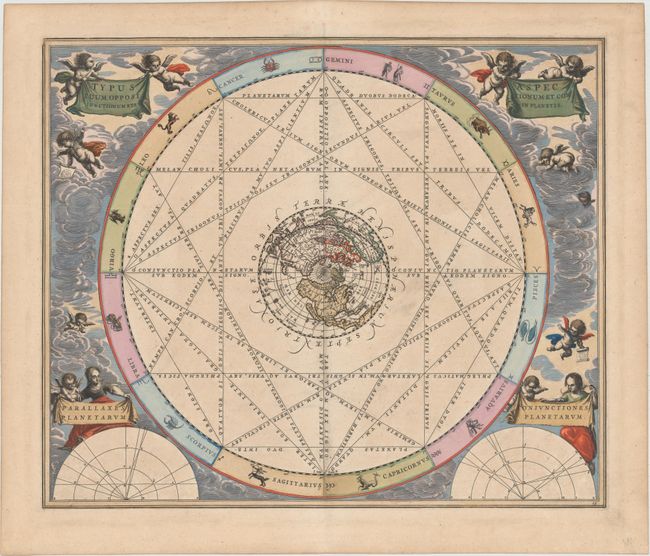
Auction 151, Lot 35
Subject: Celestial
Cellarius, Andreas
Typus Aspectuum, Oppositionum et Coniunctionum etz in Planetis, 1661
Size: 20.6 x 17.3 inches (52.3 x 43.9 cm)
Estimate: $2,200 - $2,500
Cellarius' Chart Showing the Island of California
Sold for: $1,700
Closed on 11/19/2014
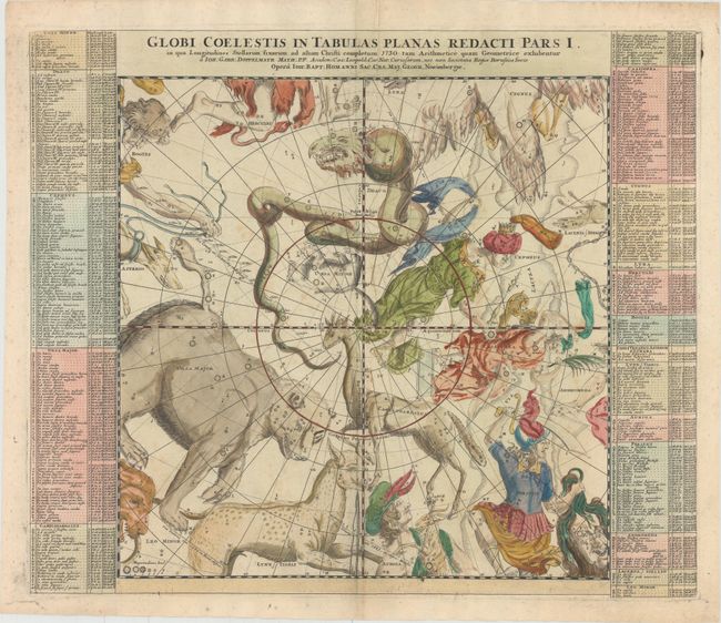
Auction 151, Lot 37
Subject: Celestial
Doppelmayr/Homann
[Lot of 6] Globi Coelestis in Tabulas Planas Redacti Pars I... [and] ... Pars II... [and] ... Pars III... [and] ... Pars IV... [and] ... Pars V... [and] ... Pars VI..., 1730
Size: 23 x 19.4 inches (58.4 x 49.3 cm)
Estimate: $800 - $1,000
Complete Matching Set of Doppelmayr's Celestial Charts on a Gnomonic Projection
Unsold
Closed on 11/19/2014
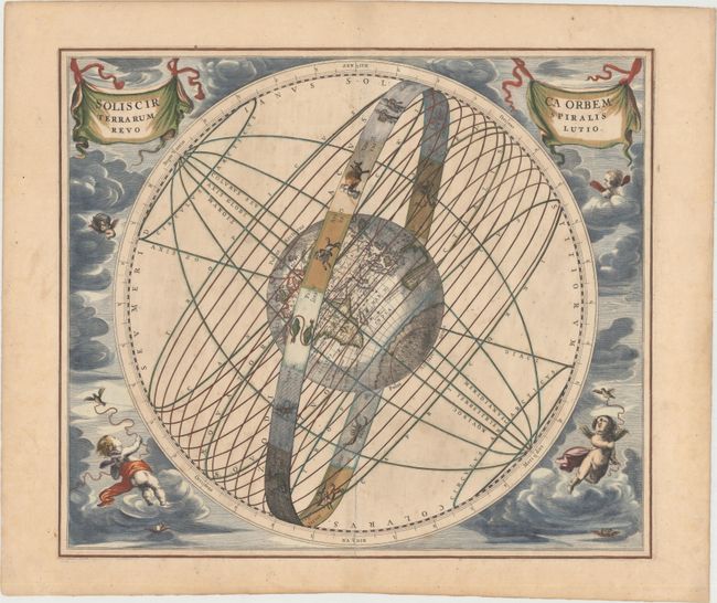
Auction 151, Lot 41
Subject: Solar System
Cellarius, Andreas
Solis Circa Orbem Terrarum Spiralis Revolutio, 1661
Size: 19.9 x 16.2 inches (50.5 x 41.1 cm)
Estimate: $2,400 - $3,000
Cellarius' Chart of the Sun Rotating Around the Earth
Sold for: $2,200
Closed on 11/19/2014
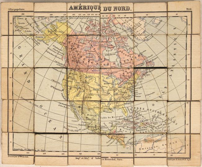
Auction 151, Lot 50
Subject: Cartographic Miscellany - Puzzle Maps
Issleib, Wilhelm
[Lot of 6] Etudes Geographiques, 1875
Size: 11.5 x 9.6 inches (29.2 x 24.4 cm)
Estimate: $800 - $1,000
A Rubik's Cube of the Continents
Sold for: $300
Closed on 11/19/2014
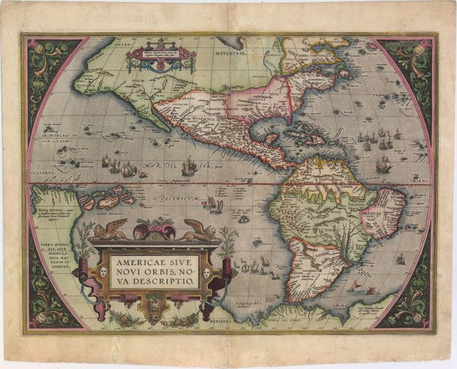
Auction 151, Lot 51
Subject: Western Hemisphere - America
Ortelius, Abraham
Americae Sive Novi Orbis, Nova Descriptio, 1587
Size: 19.1 x 14 inches (48.5 x 35.6 cm)
Estimate: $5,500 - $7,000
Ortelius' Influential Map of the New World
Sold for: $4,000
Closed on 11/19/2014
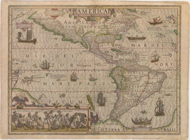
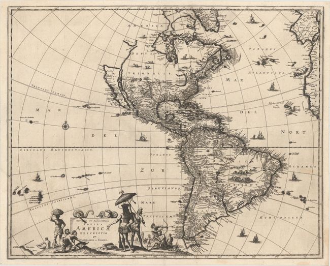
Auction 151, Lot 53
Subject: Western Hemisphere - America
Hondius, Jodocus
America, 1628
Size: 19.9 x 14.9 inches (50.5 x 37.8 cm)
Estimate: $4,750 - $6,000
Hondius' Important Map of the Americas in Full Original Color
Sold for: $2,800
Closed on 11/19/2014
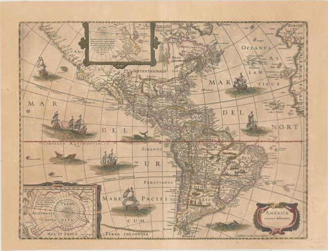
Auction 151, Lot 54
Subject: Western Hemisphere - America
Hondius/Jansson
America Noviter Delineata, 1655
Size: 19.6 x 14.9 inches (49.8 x 37.8 cm)
Estimate: $2,400 - $3,000
Jansson's Decorative Map of the Americas in Full Original Color
Sold for: $1,500
Closed on 11/19/2014
Auction 151, Lot 56
Subject: Western Hemisphere - America
Schagen, Gerrit Lucaszoon van
Novissima et Accuratissima Totius Americae Descriptio per Gerardum A. Schagen, 1671
Size: 21.5 x 17.3 inches (54.6 x 43.9 cm)
Estimate: $1,500 - $1,800
First State of Schagen's Rare Map of the Americas with California as an Island
Sold for: $1,300
Closed on 11/19/2014
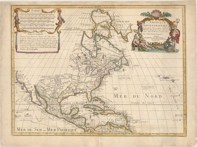
Auction 151, Lot 71
Subject: North America
Delisle, Guillaume
L'Amerique Septentrionale. Dressee sur les Observations de Mrs. de l'Academie Royale des Sciences. & Quelques Autres, & sur les Memoires les Plus Recens, 1700
Size: 23.8 x 17.9 inches (60.5 x 45.5 cm)
Estimate: $1,800 - $2,100
Delisle's Foundation Map of North America
Sold for: $1,000
Closed on 11/19/2014
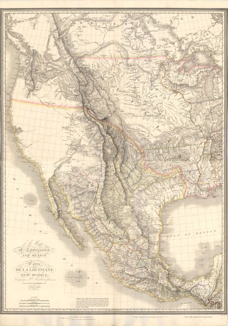
Auction 151, Lot 94
Subject: Western North America
Tardieu, Pierre Antoine
[On 2 Sheets] A Map of Louisiana and Mexico / Carte de la Louisiane et du Mexique, 1820
Size: 31 x 20.9 inches (78.7 x 53.1 cm)
Estimate: $3,000 - $4,000
Large-Scale Map Depicting the US After the Adams-Onis Treaty
Sold for: $5,500
Closed on 11/19/2014
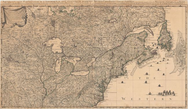
Auction 151, Lot 101
Subject: Colonial United States & Canada
Popple/Covens & Mortier
Nouvelle Carte Particuliere de l'Amerique, ou Sont Exactement Marquees, une Partie de la Baye d'Hudson… / … Ou sont Exactement Marquees la Nouvelle Bretagne, le Canada, ou Nouvelle France…, 1737
Size: 40.1 x 22.5 inches (101.9 x 57.2 cm)
Estimate: $3,500 - $4,500
The Two Northern Sheets of the Reduced Size Edition of Popple's Map
Sold for: $2,500
Closed on 11/19/2014
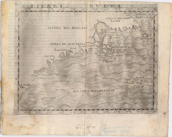
Auction 151, Lot 106
Subject: Eastern United States & Canada
Gastaldi, Giacomo
Tierra Nueva, 1548
Size: 6.7 x 5.1 inches (17 x 13 cm)
Estimate: $2,400 - $3,000
The First Published Map Devoted to the East Coast of North America
Sold for: $2,100
Closed on 11/19/2014
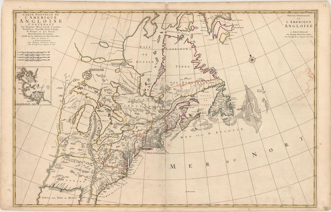
Auction 151, Lot 108
Subject: Colonial Eastern United States & Canada
Mortier, Pierre
Carte Nouvelle de l'Amerique Angloise Contenant la Virginie, Mary-Land, Caroline, Pensylvania Nouvelle Iorck, N: Iarsey N: France, et les Terres Nouvellement Decouerte..., 1700
Size: 35.8 x 23.4 inches (90.9 x 59.4 cm)
Estimate: $2,400 - $3,000
A Map Showing Fascinating Geographic Misconceptions
Unsold
Closed on 11/19/2014
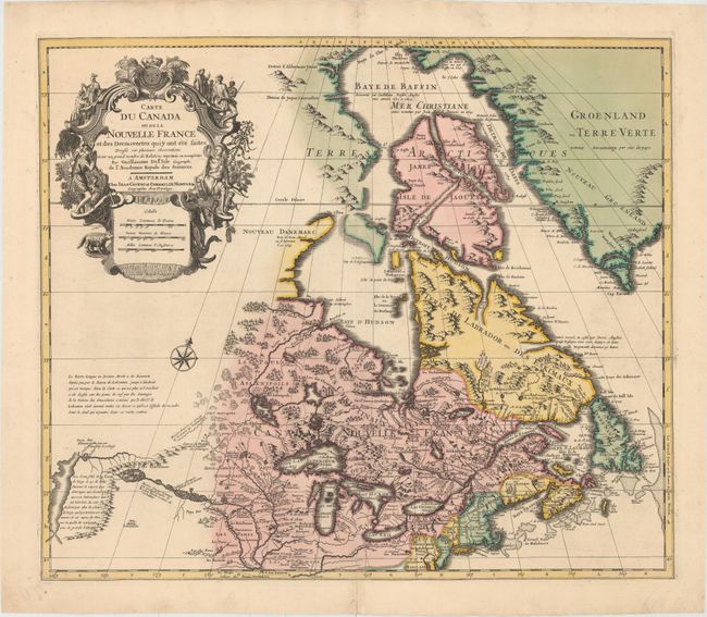
Auction 151, Lot 110
Subject: Colonial Eastern United States & Canada, Great Lakes
Delisle/Covens & Mortier
Carte du Canada ou de la Nouvelle France et des Decouvertes qui y ont ete Faites..., 1730
Size: 22.6 x 19.3 inches (57.4 x 49 cm)
Estimate: $1,400 - $1,700
One of the Most Influential Maps of Canada, the Great Lakes and Upper Midwest
Sold for: $1,400
Closed on 11/19/2014
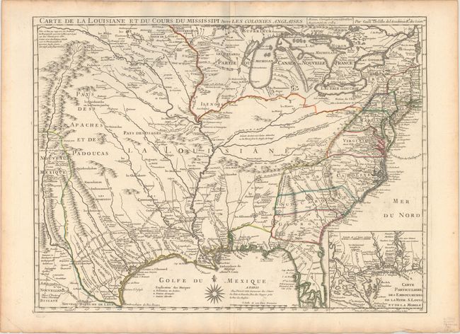
Auction 151, Lot 136
Subject: Colonial Eastern United States, Louisiana Territory
Delisle/Dezauche
Carte de la Louisiane et du Cours du Mississipi avec les Colonies Anglaises, 1782
Size: 25.6 x 19.3 inches (65 x 49 cm)
Estimate: $1,600 - $1,900
Delisle's Influential Map of the Louisiana Territory
Sold for: $1,300
Closed on 11/19/2014
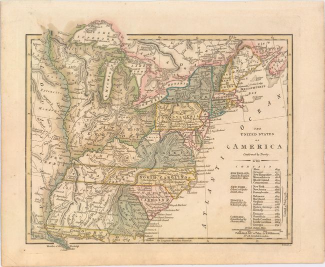
Auction 151, Lot 143
Subject: Eastern United States
Wilkinson, Robert
The United States of America Confirmed by Treaty. 1783, 1812
Size: 11.3 x 9.8 inches (28.7 x 24.9 cm)
Estimate: $900 - $1,100
Early Map of the United States Featuring Franklinia and the Indiana Land Company
Sold for: $700
Closed on 11/19/2014
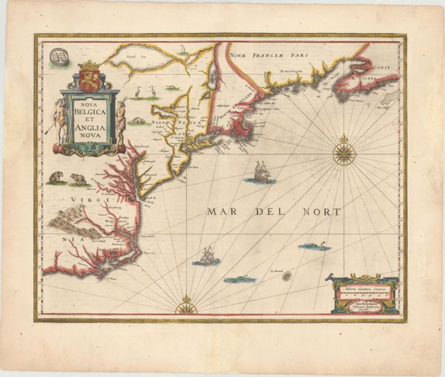
Auction 151, Lot 147
Subject: Colonial New England & Mid-Atlantic United States
Jansson, Jan
Nova Belgica et Anglia Nova, 1653
Size: 19.9 x 15.3 inches (50.5 x 38.9 cm)
Estimate: $1,600 - $1,900
Jansson's Influential Map of the East Coast
Sold for: $1,100
Closed on 11/19/2014
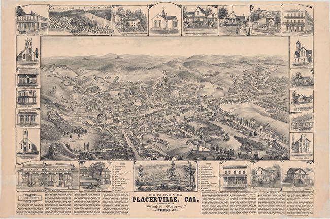
Auction 151, Lot 213
Subject: Placerville, California
Elliott, Wallace W.
Bird's Eye View Placerville, Cal., 1888
Size: 29 x 21 inches (73.7 x 53.3 cm)
Estimate: $2,400 - $3,000
View of California Gold Rush Town
Unsold
Closed on 11/19/2014
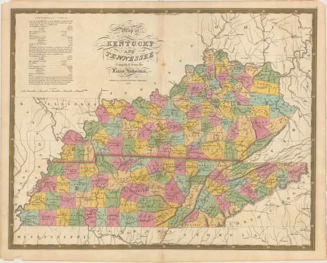
Auction 151, Lot 237
Subject: Kentucky & Tennessee
Mitchell, Samuel Augustus
Map of Kentucky and Tennessee Compiled from the Latest Authorities, 1831
Size: 21.5 x 17 inches (54.6 x 43.2 cm)
Estimate: $1,400 - $1,700
Rare Map Based on Finley's Map of 1826
Unsold
Closed on 11/19/2014
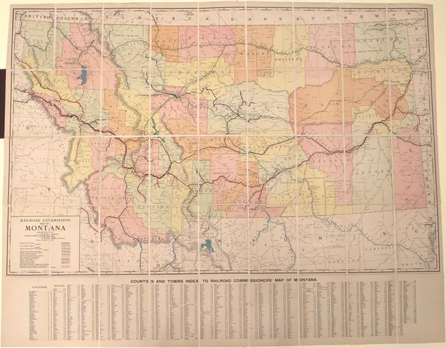
Auction 151, Lot 258
Subject: Montana, Railroads
Rand McNally & Co.
Railroad Commission Map of Montana, 1917
Size: 51.4 x 32.3 inches (130.6 x 82 cm)
Estimate: $900 - $1,100
Large, Attractive Railroad Map of Montana
Sold for: $450
Closed on 11/19/2014
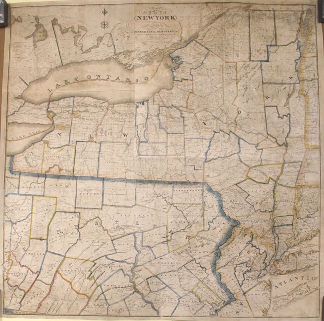
Auction 151, Lot 265
Subject: New York & Pennsylvania
Lay, Amos
Map of the State of New-York with Part of the States of Pennsylvania, New-Jersey &c., 1819
Size: 50.1 x 50 inches (127.3 x 127 cm)
Estimate: $2,750 - $3,500
Rare Wall Map of the State of New York
Sold for: $1,700
Closed on 11/19/2014
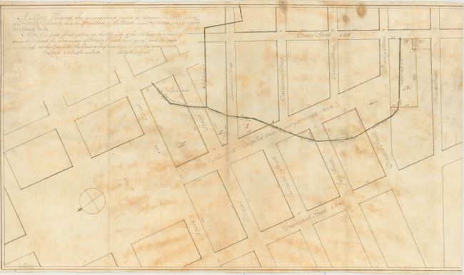
Auction 151, Lot 270
Subject: New York City, New York
[Lot of 2] A Map Shewing the Arrangement Agreed to Between the Corporation of Trinity Church, and the Proprietors of the Estate Late Ireland's, with Regard to Streets, &c. &c. [and] [Vellum Manuscript Indenture], 1796
Size: 21.5 x 12.4 inches (54.6 x 31.5 cm)
Estimate: $4,000 - $5,000
Early Manuscript Survey Map of Tribeca in Lower Manhattan
Unsold
Closed on 11/19/2014
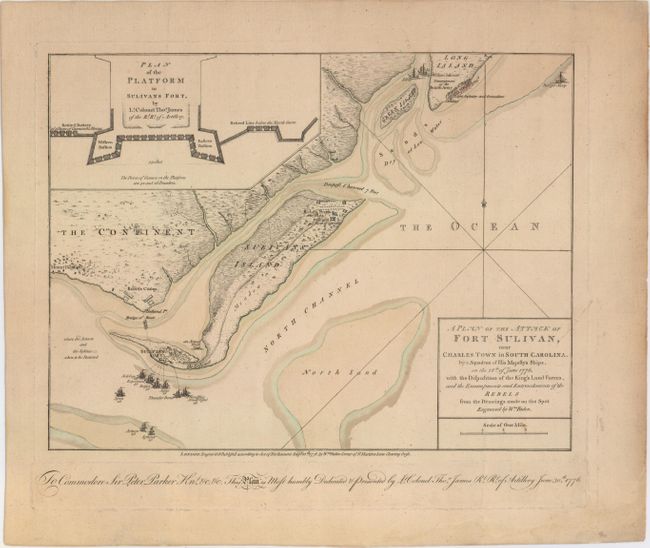
Auction 151, Lot 291
Subject: Charleston, South Carolina
Faden, William
A Plan of the Attack of Fort Sulivan, near Charles Town in South Carolina…, 1776
Size: 14.6 x 11 inches (37.1 x 27.9 cm)
Estimate: $5,500 - $7,000
Important Revolutionary War Map
Sold for: $3,750
Closed on 11/19/2014
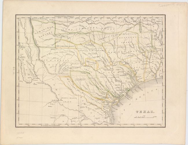
Auction 151, Lot 296
Subject: Texas
Bradford, Thomas Gamaliel
Texas, 1835
Size: 10.4 x 8.9 inches (26.4 x 22.6 cm)
Estimate: $2,500 - $3,250
First Separate Map of Texas in an American Atlas
Sold for: $2,100
Closed on 11/19/2014
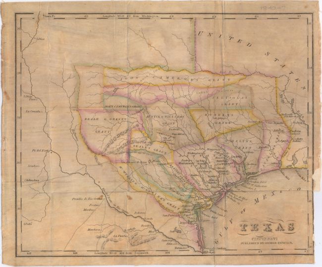
Auction 151, Lot 297
Subject: Texas
Texas, 1840
Size: 11.4 x 9.4 inches (29 x 23.9 cm)
Estimate: $4,000 - $5,000
Rare Republic Era Map
Sold for: $2,300
Closed on 11/19/2014
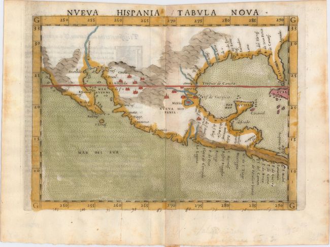
Auction 151, Lot 314
Subject: Southern United States & Mexico
Ruscelli, Girolamo
Nueva Hispania Tabula Nova, 1564
Size: 9.5 x 7.3 inches (24.1 x 18.5 cm)
Estimate: $1,300 - $1,600
A Foundation Map for the American Southwest
Sold for: $1,000
Closed on 11/19/2014
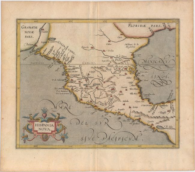
Auction 151, Lot 315
Subject: Southern United States & Mexico
Wytfliet, Cornelis
Hispania Nova, 1598
Size: 11.3 x 9 inches (28.7 x 22.9 cm)
Estimate: $900 - $1,100
Early Map of the American Southwest and Mexico
Sold for: $600
Closed on 11/19/2014
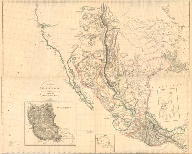
Auction 151, Lot 330
Subject: Western United States & Mexico
Arrowsmith, Aaron, Sr.
[On 4 Sheets] A New Map of Mexico and Adjacent Provinces Compiled from Original Documents, 1810
Size: 31.1 x 25.4 inches (79 x 64.5 cm)
Estimate: $15,000 - $17,000
Rare First State of Arrowsmith's Cornerstone Map of Texas and the Southwest
Sold for: $8,500
Closed on 11/19/2014
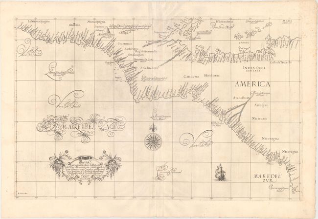
Auction 151, Lot 346
Subject: Central America
Dudley, Robert (Sir)
Carta Particolare dell' Mare del' Zur che Comincia con il Capo Lucar e Finisce con Cagidos nella Nuova Spagnia, e la Baia di Honduras…, 1646
Size: 29.4 x 18.7 inches (74.7 x 47.5 cm)
Estimate: $1,600 - $2,000
Rare First State of Dudley's Chart of Honduras and Nicaragua
Sold for: $1,200
Closed on 11/19/2014
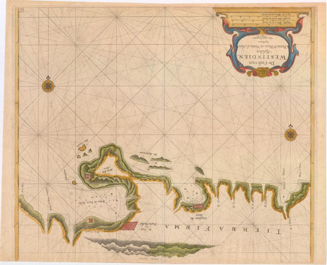
Auction 151, Lot 349
Subject: Panama
Roggeveen, Arent
De Cust van Westindien, Tusschen Punta St. Blaes, en Punta d Naes, 1675
Size: 19.8 x 16.8 inches (50.3 x 42.7 cm)
Estimate: $2,000 - $2,400
Extremely Rare Chart of the Northern Coast of Panama by Roggeveen
Sold for: $1,300
Closed on 11/19/2014
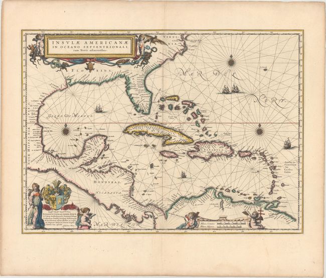
Auction 151, Lot 354
Subject: Gulf of Mexico & Caribbean
Blaeu, Willem
Insulae Americanae in Oceano Septentrionali, cum Terris Adiacentibus, 1635
Size: 20.7 x 15 inches (52.6 x 38.1 cm)
Estimate: $1,600 - $1,900
Map of the West Indies Based on Voyage of Hessel Gerritsz
Sold for: $1,200
Closed on 11/19/2014
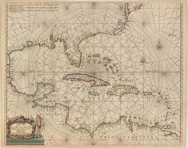
Auction 151, Lot 355
Subject: Gulf of Mexico & Caribbean
Doncker, Henrick
Pascaerte vande Caribische Eylanden, vande Barbados tot Aende Bocht van Mexico, 1659
Size: 21.5 x 17.2 inches (54.6 x 43.7 cm)
Estimate: $6,000 - $7,500
Rare Sea Chart with Interesting Depiction of the Coastline of the US
Unsold
Closed on 11/19/2014
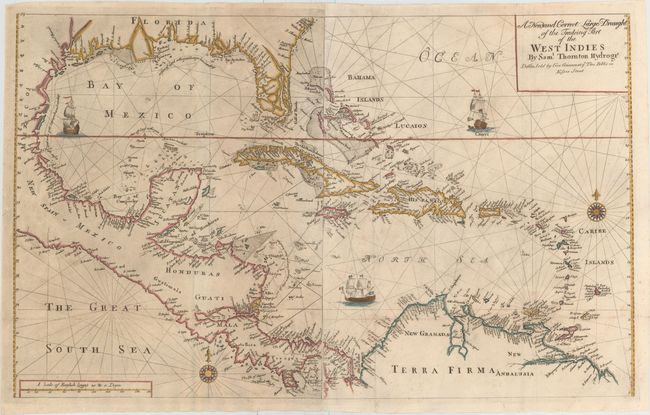
Auction 151, Lot 358
Subject: Gulf of Mexico & Caribbean
Thornton, Samuel
A New and Correct Large Draught of the Tradeing Part of the West Indies, 1749
Size: 32.8 x 20.1 inches (83.3 x 51.1 cm)
Estimate: $2,200 - $2,500
Sold for: $1,600
Closed on 11/19/2014
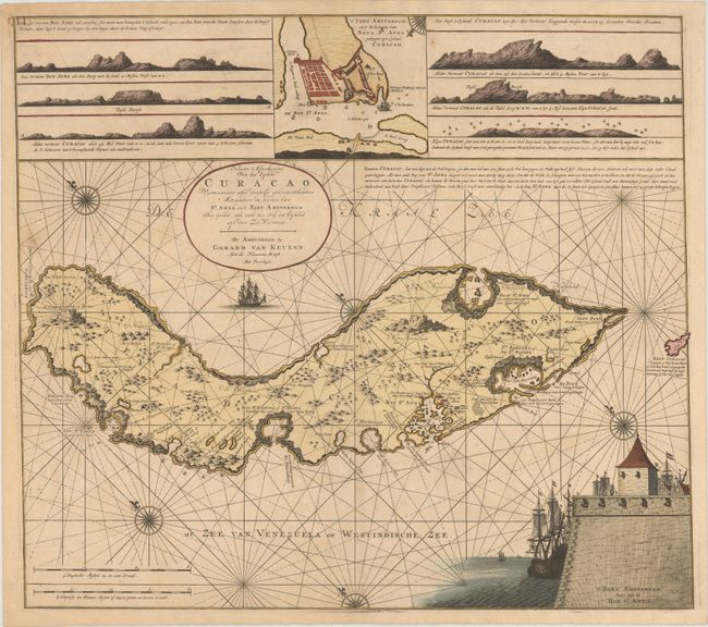
Auction 151, Lot 384
Subject: Curacao
Keulen, Gerard van
Nieuwe Afteekening van het Eyland Curacao..., 1728
Size: 23.3 x 20.6 inches (59.2 x 52.3 cm)
Estimate: $8,000 - $9,000
One of the Earliest Detailed Maps of Curacao
Unsold
Closed on 11/19/2014
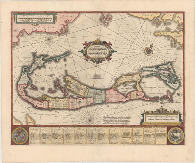
Auction 151, Lot 436
Subject: Bermuda
Hondius, Henricus
Mappa Aestivarum Insularum, Alias Barmudas Dictarum, ad Ostia Mexicani Aestuary Jacetium..., 1636
Size: 20.5 x 15.6 inches (52.1 x 39.6 cm)
Estimate: $1,400 - $1,700
Map of Bermuda Based on Richard Norwood's Famous Survey
Sold for: $800
Closed on 11/19/2014
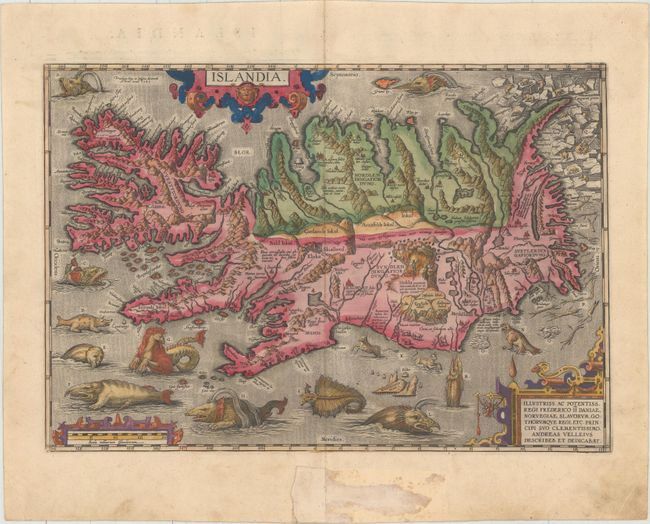
Auction 151, Lot 441
Subject: Iceland
Ortelius, Abraham
Islandia, 1585
Size: 19.4 x 13.3 inches (49.3 x 33.8 cm)
Estimate: $9,000 - $11,000
One of Ortelius' Most Decorative Maps
Sold for: $6,000
Closed on 11/19/2014
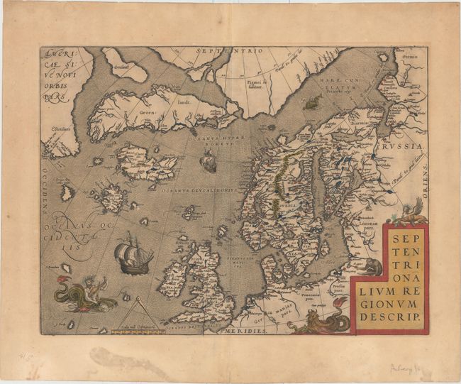
Auction 151, Lot 443
Subject: Arctic Ocean
Ortelius, Abraham
Septentrionalium Regionum Descrip., 1603
Size: 19.2 x 14.3 inches (48.8 x 36.3 cm)
Estimate: $2,400 - $3,000
Ortelius' Map of the Arctic with Several Mythical Islands
Sold for: $1,400
Closed on 11/19/2014
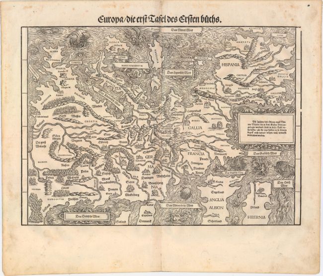
Auction 151, Lot 444
Subject: Europe
Stumpf, Johann
Europa/ die Erst Tafel des Ersten Buchs, 1548
Size: 15.4 x 11 inches (39.1 x 27.9 cm)
Estimate: $2,000 - $2,300
Rare Decorative Map of Europe with South Oriented to the Top
Sold for: $3,250
Closed on 11/19/2014
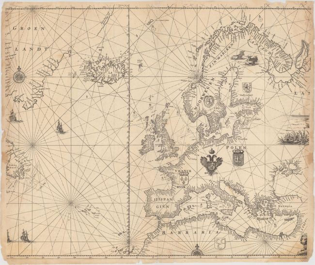
Auction 151, Lot 449
Subject: Europe & North Atlantic
Doncker, Henrick
[Pascaart van Europa op Wassende Graaden door Dirck Rembrantsz van Nierop], 1690
Size: 23.7 x 19.9 inches (60.2 x 50.5 cm)
Estimate: $1,400 - $1,800
Scarce Chart Depicting Updated Coastline of Greenland
Sold for: $4,250
Closed on 11/19/2014
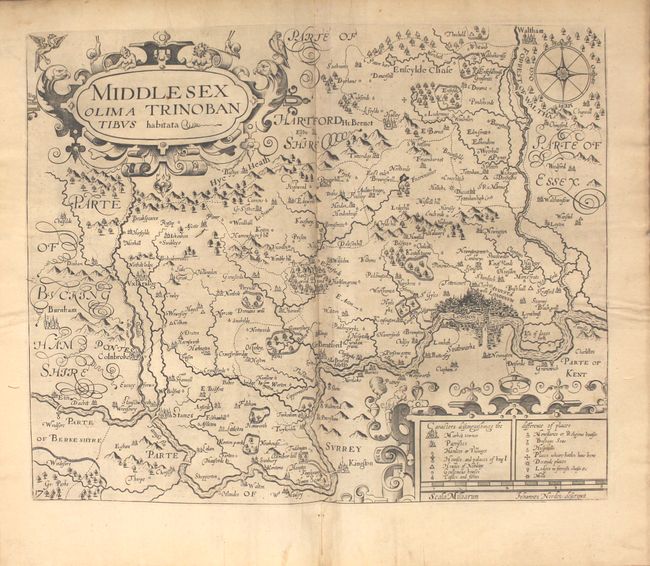
Auction 151, Lot 453
Subject: Britain, Atlases
Camden, William
Britain, or a Chorographicall Description of the Most Flourishing Kingdomes, England, Scotland, and Ireland, and the Islands Adjoyning, our of the Depth of Antiquitie, 1637
Size: 9.5 x 13.7 inches (24.1 x 34.8 cm)
Estimate: $2,300 - $2,750
1637 Edition of Camden's Britannia with Maps by Kip and Hole
Unsold
Closed on 11/19/2014
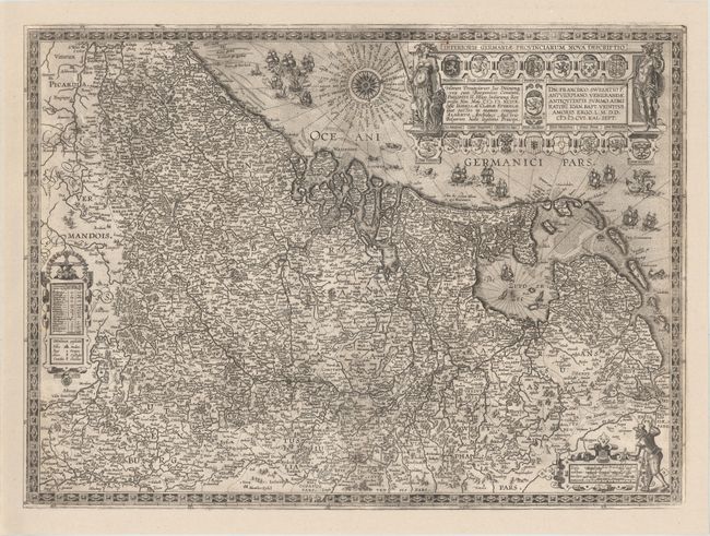
Auction 151, Lot 494
Subject: Low Countries
Ortelius, Abraham
Inferioris Germaniae Provinciarum Nova Descriptio, 1609
Size: 21.9 x 16.3 inches (55.6 x 41.4 cm)
Estimate: $4,000 - $5,000
Rare Decorative Map of the Low Countries
Unsold
Closed on 11/19/2014
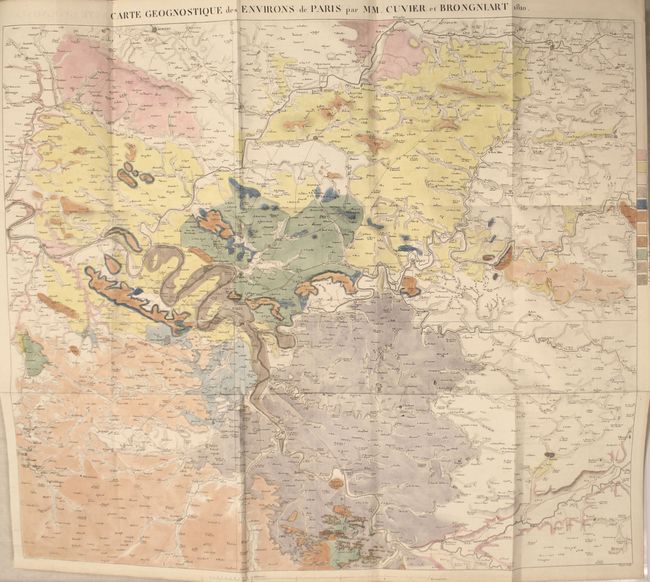
Auction 151, Lot 513
Subject: Paris, France
Memoires de la Classe des Sciences Mathematiques et Physiques de l'Institut Imperial de France, 1811
Size: 8.1 x 10.3 inches (20.6 x 26.2 cm)
Estimate: $1,400 - $1,700
First Modern Geological Map of Paris, France
Sold for: $900
Closed on 11/19/2014

Auction 151, Lot 585
Subject: Rome, Italy
Piranesi, Giovanni Battista
Veduta dell' Anfiteatro Flavio detto il Colosseo, 1850
Size: 27.9 x 19.3 inches (70.9 x 49 cm)
Estimate: $2,000 - $2,400
Piranesi's Famous Bird's-Eye View of the Coliseum
Sold for: $1,000
Closed on 11/19/2014
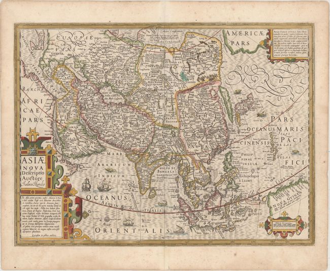
Auction 151, Lot 617
Subject: Asia
Hondius, Jodocus
Asiae Nova Descriptio, 1623
Size: 19.8 x 14.8 inches (50.3 x 37.6 cm)
Estimate: $1,400 - $1,800
Sold for: $1,300
Closed on 11/19/2014
55 lots
Page 1 of 2