Showing Featured Lots(remove filter)
Showing results for:Auction 147
Catalog Archive
63 lots
Page 1 of 2
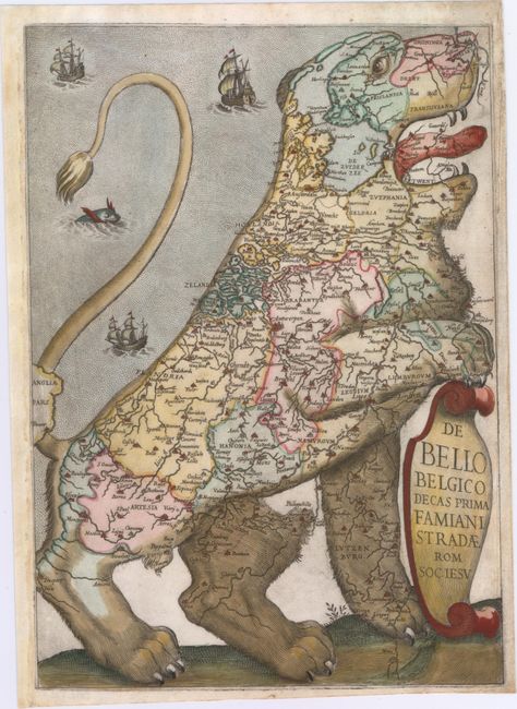
Auction 147, Lot 1
Subject: Frontispiece - Low Countries
Strada, Famiamo, S.J.
De Bello Belgico Decas Prima Famiani Stradae Rom. Soc. Iesu, 1632
Size: 8.8 x 12.5 inches (22.4 x 31.8 cm)
Estimate: $5,500 - $7,000
The Largest Strada Leo Belgicus
Unsold
Closed on 11/20/2013
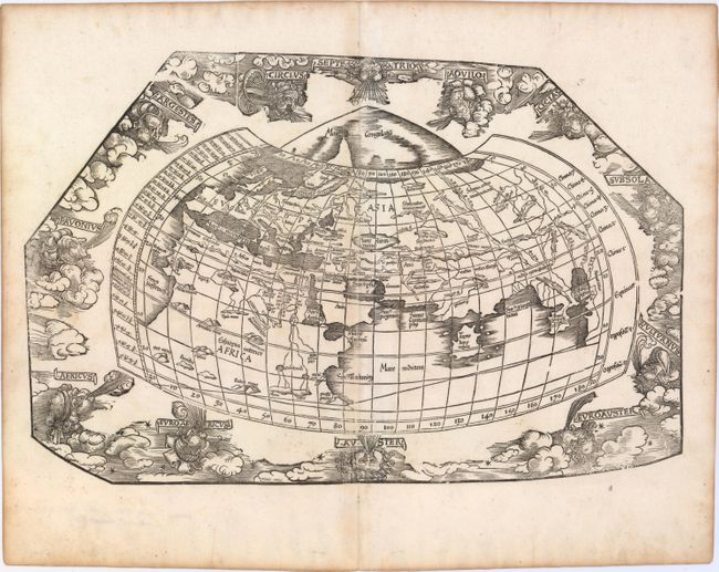
Auction 147, Lot 16
Subject: World
Ptolemy/Fries
[Untitled - World], 1535
Size: 18.2 x 11.7 inches (46.2 x 29.7 cm)
Estimate: $4,000 - $4,750
Sold for: $3,000
Closed on 11/20/2013
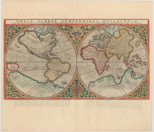
Auction 147, Lot 17
Subject: World
Mercator, Rumold
Orbis Terrae Compendiosa Descriptio, 1587
Size: 20.6 x 11.4 inches (52.3 x 29 cm)
Estimate: $6,000 - $8,000
Mercator's Double-Hemisphere World Map
Sold for: $3,000
Closed on 11/20/2013
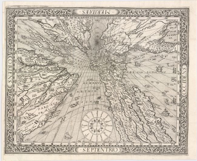
Auction 147, Lot 18
Subject: World
Ritter, Franz
[Untitled - World], 1610
Size: 14.4 x 11.6 inches (36.6 x 29.5 cm)
Estimate: $12,000 - $14,000
Ritter's Fascinating Sundial World Map
Sold for: $14,500
Closed on 11/20/2013
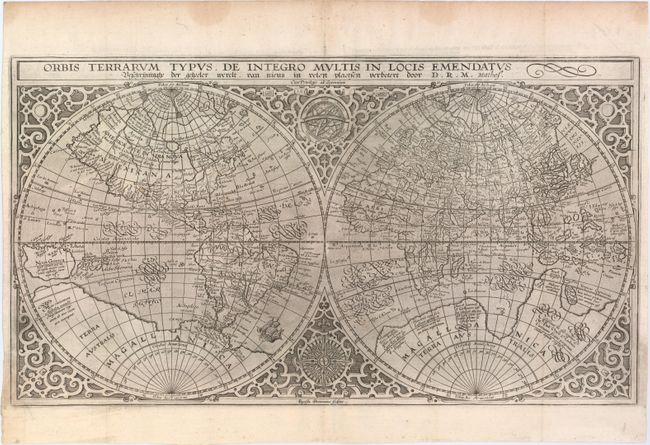
Auction 147, Lot 20
Subject: World
Plancius, Petrus
Orbis Terrarum Typus de Integro Multis in Locis Emendatus..., 1625
Size: 20.3 x 11.3 inches (51.6 x 28.7 cm)
Estimate: $3,500 - $4,250
Sold for: $2,300
Closed on 11/20/2013

Auction 147, Lot 21
Subject: World
Blaeu, Willem
Nova Totius Terrarum Orbis Geographica ac Hydrographica Tabula, 1635
Size: 21.5 x 16.1 inches (54.6 x 40.9 cm)
Estimate: $15,000 - $18,000
Blaeu's Magnificent Carte-a-Figures World Map
Sold for: $12,500
Closed on 11/20/2013

Auction 147, Lot 22
Subject: World
Wit, Frederick de
Nova Orbis Tabula, in Lucem Edita, 1670
Size: 22.4 x 18.9 inches (56.9 x 48 cm)
Estimate: $4,500 - $5,500
De Wit's Stunning Double-Hemisphere Map
Sold for: $3,000
Closed on 11/20/2013
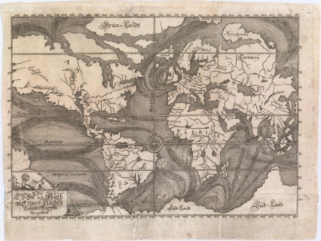
Auction 147, Lot 23
Subject: World
Happel, Everard Werner
Die Ebbe und Fluth auff einer Flachen Landt-Karten Furgestelt, 1687
Size: 11.4 x 8 inches (29 x 20.3 cm)
Estimate: $1,100 - $1,300
One of the Earliest Thematic World Maps
Sold for: $800
Closed on 11/20/2013

Auction 147, Lot 25
Subject: World
Jaillot, Alexis-Hubert
Nova Orbis Tabula, ad Usum Serenissimi Burgundiae Ducis / Mappe Monde ou Description du Globe Terrestre & Aquatique Presentee a Monseigneur le Duc de Bourgogne…, 1694
Size: 24.3 x 19.5 inches (61.7 x 49.5 cm)
Estimate: $4,500 - $5,500
Jaillot's Lavishly Decorated World Map in Full Original Color
Unsold
Closed on 11/20/2013
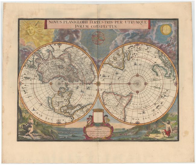
Auction 147, Lot 26
Subject: World
Blaeu/Valck
Novus Planiglobii Terrestris per Utrumque Polum Conspectus, 1695
Size: 21.1 x 15.9 inches (53.6 x 40.4 cm)
Estimate: $6,500 - $7,500
Superb World Map on a Polar Projection
Sold for: $6,000
Closed on 11/20/2013
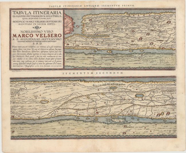
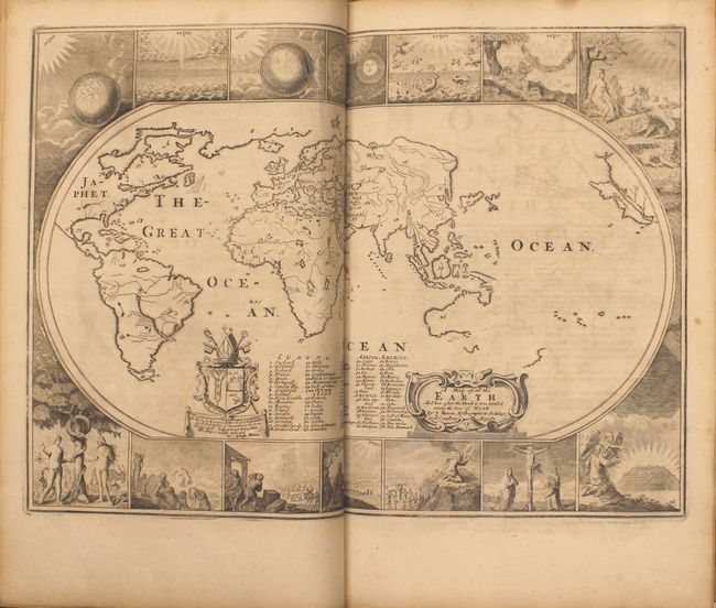
Auction 147, Lot 47
Subject: Ancient World
Ortelius, Abraham
Tabula Itineraria ex Illustri Peutingerorum Bibliotheca…Nobilissimo Viro Marco Velsero, 1598
Size: 20.5 x 15.5 inches (52.1 x 39.4 cm)
Estimate: $7,000 - $8,500
Ortelius' Scarce Peutinger Table
Sold for: $5,000
Closed on 11/20/2013

Auction 147, Lot 51
Subject: North Pole
Hondius/deWit
Poli Arctici, et Circumiacentium Terrarum Descriptio Novissima, 1715
Size: 19.6 x 17.1 inches (49.8 x 43.4 cm)
Estimate: $1,900 - $2,200
Sold for: $1,200
Closed on 11/20/2013

Auction 147, Lot 68
Subject: Western Hemisphere - America, Atlantic Ocean
Waldseemuller/Fries
E. Tabula Terre Nova F.D.W., 1522
Size: 17.1 x 12.8 inches (43.4 x 32.5 cm)
Estimate: $21,000 - $25,000
Rare First Issue of the Waldseemuller/Fries "Admiral's Map"
Unsold
Closed on 11/20/2013

Auction 147, Lot 69
Subject: Western Hemisphere
Hondius, Henricus
America Noviter Delineata, 1631
Size: 19.7 x 14.9 inches (50 x 37.8 cm)
Estimate: $2,000 - $2,300
Sold for: $1,600
Closed on 11/20/2013

Auction 147, Lot 71
Subject: Western Hemisphere
Danckerts, Justus
Recentissima Novi Orbis sive Americae Septentrionalis et Meridionalis Tabula, 1696
Size: 23 x 19.5 inches (58.4 x 49.5 cm)
Estimate: $1,800 - $2,100
Sold for: $1,300
Closed on 11/20/2013
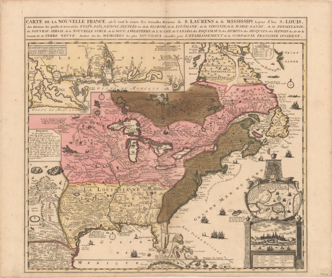
Auction 147, Lot 111
Subject: Colonial Eastern United States & Canada
Fer, Nicolas de
Carte de la Nouvelle France, ou se voit le cours des Grandes Rivieres de S. Laurens & de Mississipi, Aujour d'hui S. Louis…, 1719
Size: 21.7 x 19.6 inches (55.1 x 49.8 cm)
Estimate: $2,300 - $3,000
Striking Map of French Colonial Possessions
Unsold
Closed on 11/20/2013
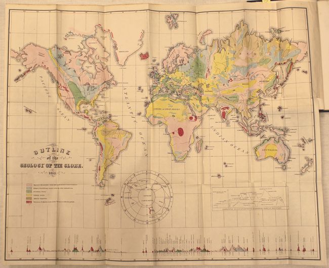
Auction 147, Lot 122
Subject: United States & Canada
Hitchcock, Edward
[Maps with Report] A Geological Map of the United States and Canada [and] Outline of the Geology of the Globe, 1853
Size: See Description
Estimate: $1,000 - $1,300
First Edition of Hitchcock's Important Maps and Report
Sold for: $1,300
Closed on 11/20/2013
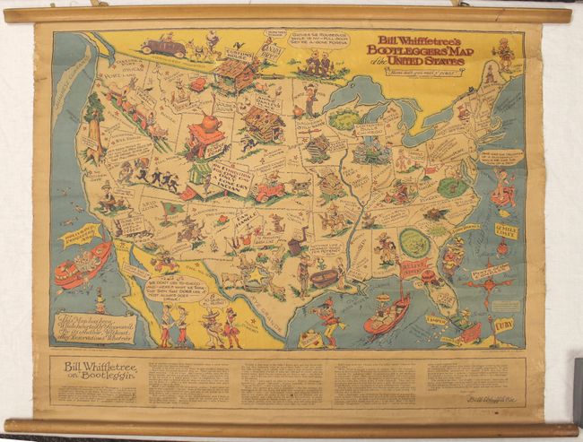
Auction 147, Lot 132
Subject: United States
Bill Whiffletree's Bootlegger's Map of the United States, 1925
Size: 30.1 x 20.3 inches (76.5 x 51.6 cm)
Estimate: $1,000 - $1,200
Sold for: $2,400
Closed on 11/20/2013
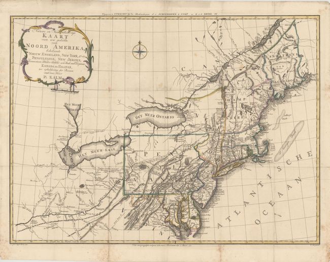
Auction 147, Lot 137
Subject: Colonial Northeastern United States
Kalm, Peter
Nieuwe en Nauwkeurige Kaart van een gedeelte van Noord Amerika, behelzende Nieuw Engeland, New York, Pensylvania, New Jersey, Connecticut, Rhode Island, een Stuk van Virginia, Kanada en Halifax, 1772
Size: 29.9 x 22 inches (75.9 x 55.9 cm)
Estimate: $1,400 - $1,800
Sold for: $750
Closed on 11/20/2013
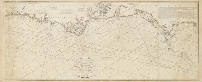
Auction 147, Lot 145
Subject: Eastern United States
Norie, John William
To the Independent Mariners of America, This Chart of their Coast from Savannah to Boston is most Respectfully Dedicated…, 1852
Size: 61 x 25.3 inches (154.9 x 64.3 cm)
Estimate: $2,300 - $2,750
Rare Blue-Back Chart of the East Coast
Unsold
Closed on 11/20/2013
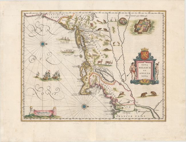
Auction 147, Lot 148
Subject: Colonial New England & Mid-Atlantic
Blaeu, Willem
Nova Belgica et Anglia Nova, 1662
Size: 19.7 x 15.2 inches (50 x 38.6 cm)
Estimate: $3,250 - $4,000
Important Map of Colonial New England and the Mid-Atlantic
Sold for: $2,200
Closed on 11/20/2013
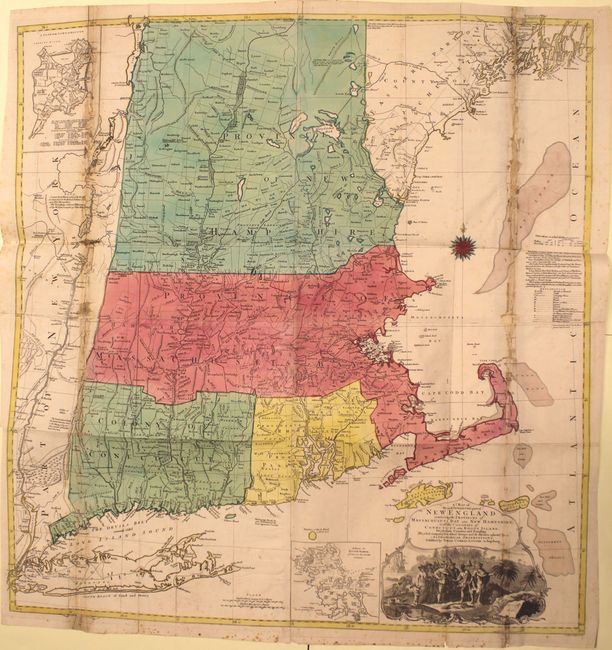
Auction 147, Lot 150
Subject: Colonial New England
Lotter, Tobias Conrad
A Map of the Most Inhabited Part of New England, Containing the Provinces of Massachusets Bay and New Hampshire, with the Colonies of Conecticut and Rhode Island…, 1776
Size: 38 x 40.2 inches (96.5 x 102.1 cm)
Estimate: $3,000 - $4,000
Sold for: $900
Closed on 11/20/2013
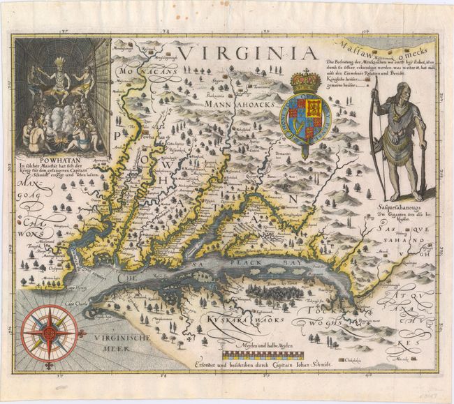
Auction 147, Lot 153
Subject: Colonial Mid-Atlantic
Merian, Matthaus
Virginia - Erforshet und Beschriben durch Capitain Iohan Schmidt, 1627
Size: 14 x 11.3 inches (35.6 x 28.7 cm)
Estimate: $8,000 - $9,500
The Third Derivative of Smith's Map of Virginia
Sold for: $6,000
Closed on 11/20/2013
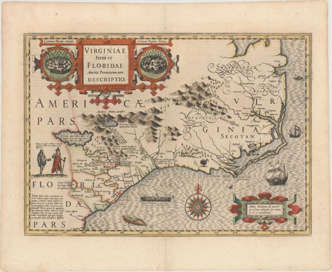
Auction 147, Lot 162
Subject: Colonial Southeast
Hondius, Jodocus
Virginiae Item et Floridae Americae Provinciarum, Nova Descriptio, 1619
Size: 19 x 13.5 inches (48.3 x 34.3 cm)
Estimate: $2,400 - $3,000
A Seminal Map of the Southeast and Early American Cartography
Sold for: $2,750
Closed on 11/20/2013
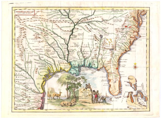
Auction 147, Lot 163
Subject: Colonial Southeast
Albrizzi, Girolamo
Carta Geografica della Florida nell' America Settentrionale, 1740
Size: 16.8 x 12.8 inches (42.7 x 32.5 cm)
Estimate: $1,300 - $1,600
Unsold
Closed on 11/20/2013
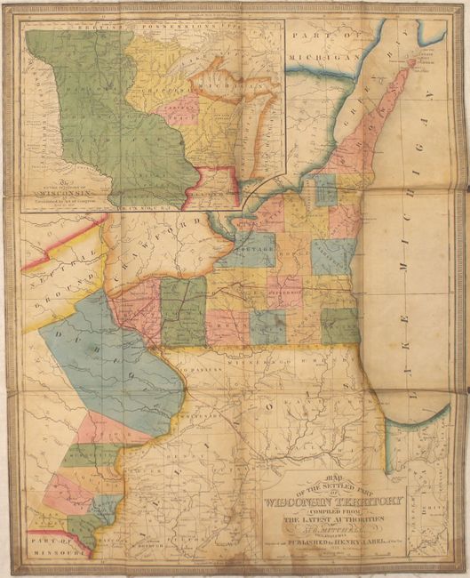
Auction 147, Lot 181
Subject: North Central United States
Mitchell/Young
Map of the Settled Part of Wisconsin Territory Compiled from the Latest Authorities, 1838
Size: 17.6 x 21.8 inches (44.7 x 55.4 cm)
Estimate: $4,000 - $5,000
Very Early and Scarce Map of Wisconsin Territory
Unsold
Closed on 11/20/2013
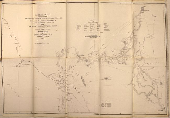
Auction 147, Lot 197
Subject: Northern California
Ringgold, Cadwalader
A Series of Charts with Sailing Directions, Embracing Surveys of the Farallones, Entrance to the Bay of San Francisco ... State of California, 1852
Size: 7.7 x 11.5 inches (19.6 x 29.2 cm)
Estimate: $2,000 - $2,500
Important Coastal Surveys Leading to the Gold Region
Sold for: $1,000
Closed on 11/20/2013
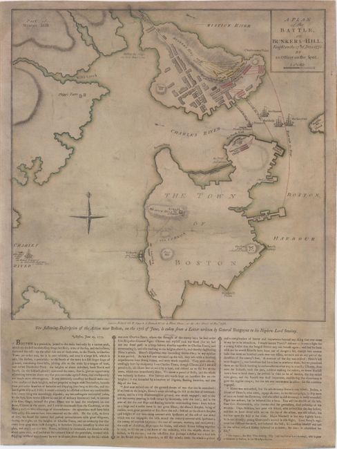
Auction 147, Lot 225
Subject: Boston, Massachusetts
Sayer & Bennett
A Plan of the Battle, on Bunkers Hill. Fought on the 17th of June 1775. By an Officer on the Spot, 1775
Size: 13.7 x 13.6 inches (34.8 x 34.5 cm)
Estimate: $13,000 - $15,000
Rare British Broadside of the Battle of Bunkers Hill
Sold for: $7,000
Closed on 11/20/2013
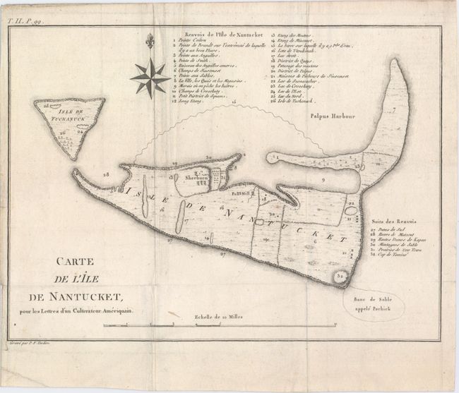
Auction 147, Lot 226
Subject: Nantucket, Massachusetts
Crevecoeur, Michel Guillaume De
Carte de l'Ile de Nantucket, pour les Lettres d’un Cultivateur Ameriquain, 1787
Size: 11 x 8 inches (27.9 x 20.3 cm)
Estimate: $1,400 - $1,700
Sold for: $900
Closed on 11/20/2013
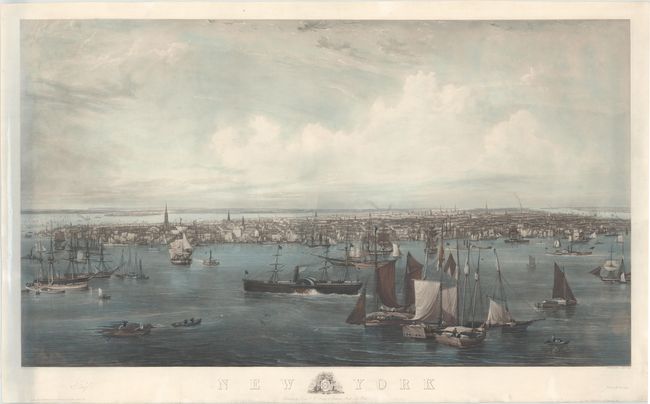
Auction 147, Lot 234
Subject: New York City, New York
New York, 1855
Size: 50.5 x 29 inches (128.3 x 73.7 cm)
Estimate: $4,000 - $5,000
Sold for: $2,550
Closed on 11/20/2013
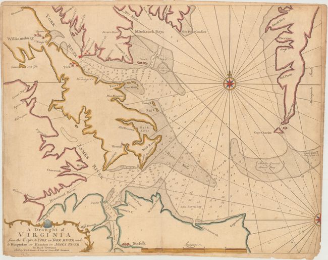
Auction 147, Lot 248
Subject: Chesapeake Bay, Virginia
Mount & Page
A Draught of Virginia from the Capes to York in York River and to Kuiquotan or Hamton in James River, 1751
Size: 23.9 x 18.1 inches (60.7 x 46 cm)
Estimate: $1,200 - $1,500
Unsold
Closed on 11/20/2013
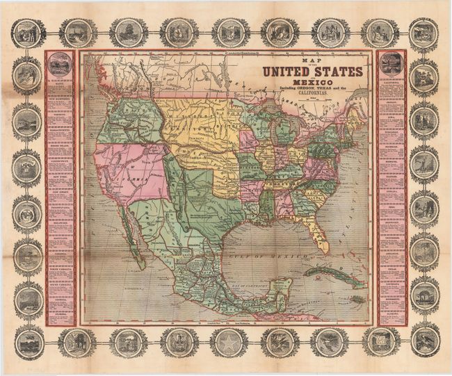
Auction 147, Lot 254
Subject: United States & Mexico
Haven, John
Map of the United States and Mexico Including Oregon, Texas and the Californias, 1846
Size: 15.3 x 14.3 inches (38.9 x 36.3 cm)
Estimate: $1,400 - $1,700
Sold for: $700
Closed on 11/20/2013
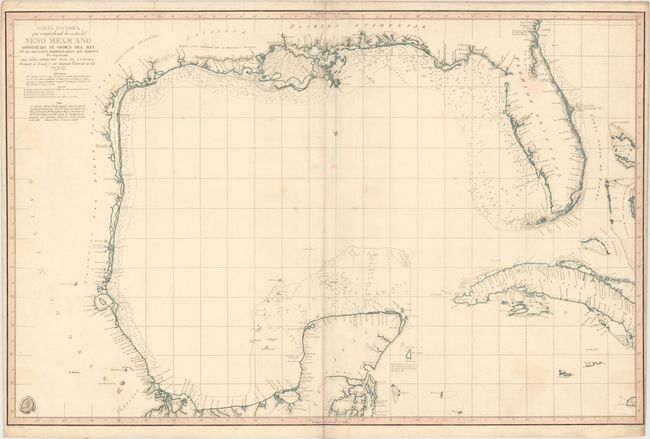
Auction 147, Lot 284
Subject: Gulf of Mexico, Texas
Direccion de Hidrografia
Carta Esferica que Comprehende las Costas del Seno Mexicano Construida de Orden del Rey en el Deposito Hidrografico de Marina, 1803
Size: 36.6 x 24 inches (93 x 61 cm)
Estimate: $8,000 - $12,000
One of Six Maps Most Desirable for a Texas Collection According to Streeter
Unsold
Closed on 11/20/2013

Auction 147, Lot 285
Subject: Gulf of Mexico, Republic of Texas
Direccion de Hidrografia
Carta de las Costas de la Escambia, Alabama y Bocas del Rio Misisipi, la Luisiana, Tejas, con la Provincia del Nuevo Santander en el Golfo de Mejico, 1846
Size: 38.2 x 24.6 inches (97 x 62.5 cm)
Estimate: $6,000 - $7,500
Unsold
Closed on 11/20/2013
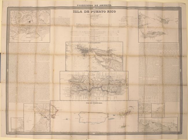
Auction 147, Lot 296
Subject: Puerto Rico
Coello y Quesada, Francisco
Isla de Puerto Rico, 1851
Size: 40.4 x 29.2 inches (102.6 x 74.2 cm)
Estimate: $1,400 - $1,800
Unsold
Closed on 11/20/2013

Auction 147, Lot 317
Subject: South America
Bry, Theodore de
Americae Pars Magis Cognita, 1592
Size: 17.4 x 14.3 inches (44.2 x 36.3 cm)
Estimate: $4,000 - $5,000
Sold for: $2,000
Closed on 11/20/2013

Auction 147, Lot 359
Subject: Atlantic Ocean
Wit, Frederick de
Terra Nova, ac Maris Tractus circa Novam Franciam, Angliam, Belgium, Venezuelam Novam Andalusiam, Guianam et Brasiliam - Terra Neuf, en de Custen van Nieu Vranckryck, Nieu Engeland, Nieu Nederland, Nieu Andalusia, Guiana en Venezuela, 1675
Size: 22.2 x 19 inches (56.4 x 48.3 cm)
Estimate: $1,300 - $1,600
Magnificent Decorative Chart of the Western Atlantic
Unsold
Closed on 11/20/2013
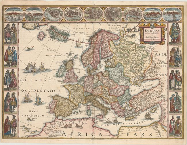
Auction 147, Lot 385
Subject: Europe
Blaeu, Willem
Europa Recens Descripta, 1640
Size: 22.1 x 16.4 inches (56.1 x 41.7 cm)
Estimate: $3,500 - $4,250
Blaeu's Carte-a-Figures Map of Europe
Sold for: $3,000
Closed on 11/20/2013

Auction 147, Lot 391
Subject: Europe
Het Gekkenhuis (Oud Liedje, Nieuwe Wijs), 1915
Size: 20.6 x 16.4 inches (52.3 x 41.7 cm)
Estimate: $2,750 - $3,500
Rare Dutch Satirical Map of World War I
Sold for: $1,750
Closed on 11/20/2013

Auction 147, Lot 392
Subject: Britain
Jansson, Jan
Britannia Prout Divisa fuit Temporibus Anglo-Saxonum, Praesertim Durante Illorum Heptarchia, 1646
Size: 20.6 x 16.6 inches (52.3 x 42.2 cm)
Estimate: $3,000 - $4,000
Sold for: $1,850
Closed on 11/20/2013

Auction 147, Lot 395
Subject: Britain
Keulen, Johannes van
Paskaart van't Canaal Engelandt Schotlandt en Yrland. Naaukeurig. Opgestelt en Dienstig Voor die Achter Yrland Omkomen…, 1698
Size: 23 x 20 inches (58.4 x 50.8 cm)
Estimate: $1,300 - $1,500
Sold for: $650
Closed on 11/20/2013

Auction 147, Lot 477
Subject: Russia
Blaeu, Willem
Tabula Russiae … M.DC.XIIII, 1635
Size: 21.5 x 16.8 inches (54.6 x 42.7 cm)
Estimate: $3,000 - $3,750
Unsold
Closed on 11/20/2013

Auction 147, Lot 523
Subject: Milan, Italy
Blaeu/Mortier
Mediolanum vulgo Milano, 1704
Size: 23.5 x 19 inches (59.7 x 48.3 cm)
Estimate: $2,400 - $3,000
Sold for: $1,500
Closed on 11/20/2013

Auction 147, Lot 527
Subject: Venice, Italy - Book
Das Malerische, Monumentale, Historische und Artistische Venedig. Eine Darstellung Seiner Haupt-Ansichten und Alten Gebrauche…, 1857
Size: 19.5 x 13.5 inches (49.5 x 34.3 cm)
Estimate: $8,000 - $10,000
Magnificent Views of Venice, Italy
Unsold
Closed on 11/20/2013

Auction 147, Lot 538
Subject: Cyprus
Jansson, Jan
Cyprus Insula, 1653
Size: 19.8 x 15.1 inches (50.3 x 38.4 cm)
Estimate: $1,800 - $2,100
Sold for: $1,200
Closed on 11/20/2013

Auction 147, Lot 548
Subject: Eastern Mediterranean & Middle East
Bonne/Lattre
Carte des Regions et des Lieux dont il est Parle dans le Nouveau Testament, 1775
Size: 17.6 x 12.2 inches (44.7 x 31 cm)
Estimate: $140 - $170
Unsold
Closed on 11/20/2013
Auction 147, Lot 567
Subject: Holy Land, Bible
Moxon, Joseph
The Holy Bible, Containing the Old and New Testaments... [bound with] The Book of Common Prayer [and 6 Biblical maps], 1715
Size: 10.6 x 16.8 inches (26.9 x 42.7 cm)
Estimate: $1,800 - $2,100
Holy Bible Featuring Set of 6 Biblical Maps
Sold for: $2,000
Closed on 11/20/2013

Auction 147, Lot 569
Subject: Holy Land
Ortelius, Abraham
Abrahami Patriarchae Peregrinatio, et Vita, 1590
Size: 18 x 13.9 inches (45.7 x 35.3 cm)
Estimate: $3,000 - $3,750
Elaborate Map of the Holy Land, Illustrating the Life of Abraham
Sold for: $2,400
Closed on 11/20/2013

Auction 147, Lot 576
Subject: Holy Land
Danckerts, Theodore
Iudaea sive Terra Sancta quae Israelitarum in suas Duodecim Tribus Destincta Secretis ab Invicem Regnis Iuda, et Israel..., 1698
Size: 22.5 x 20 inches (57.2 x 50.8 cm)
Estimate: $1,100 - $1,400
Unsold
Closed on 11/20/2013
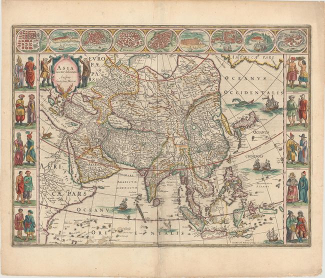
Auction 147, Lot 604
Subject: Asia
Blaeu, Willem
Asia Noviter Delineata, 1660
Size: 22 x 16.3 inches (55.9 x 41.4 cm)
Estimate: $3,750 - $4,500
Magnificent Carte-a-Figures Map of Asia
Sold for: $2,600
Closed on 11/20/2013
63 lots
Page 1 of 2